This item has been sold, but you can get on the Waitlist to be notified if another example becomes available.
1957 Metsker Map of Olympic Peninsula, Washington
PugetSoundCountry-metsker-1957$175.00

Title
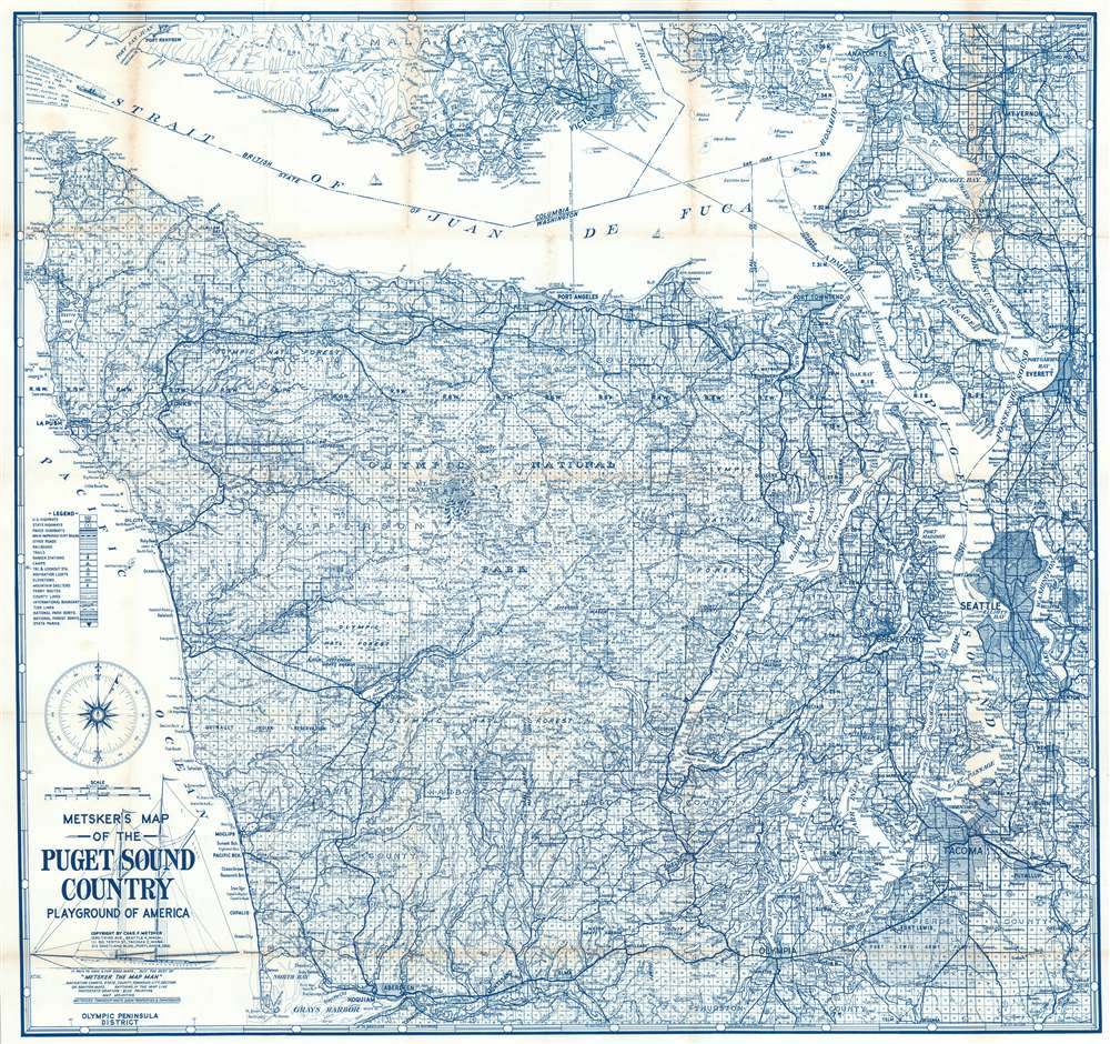
Metsker's Map of the Puget Sound Country Playground of America.
1957 (undated) 29.5 x 31.25 in (74.93 x 79.375 cm) 1 : 253440
1957 (undated) 29.5 x 31.25 in (74.93 x 79.375 cm) 1 : 253440
Description
This is a 1957 Charles Metsker map of the Olympic Peninsula, Washington. Depicting from southern British Columbia to Grays Harbor, Mesker paints the peninsula as an outdoor 'playground'. Both Olympic National Park and Olympic National Forest are illustrated and labeled. The region's rivers, mountain peaks, and other outdoor sights are identified, along with the camps and cabins where outdoor enthusiasts can stay. Seattle, Tacoma, and other cities ] and also labeled, along with military bases.
Publication History and Census
This map was created and published by Charles Metsker in 1957. Three examples are cataloged in OCLC, part of the institutional collections at the University of Oregon, the University of Washington, and Washington State University.Cartographer
Charles Frederick Metsker (December 5, 1881 - October 6, 1966) was an American cartographer and publisher. Born in Douglas County, Kansas, Metsker's family moved to Winlock, Washington, in 1900. Metsker began publishing maps in 1901 in Tacoma, Washington. By the 1920s he was advertising as 'Metsker the Map Man' in Washington and Oregon newspapers. He opened a brick and mortar store in 1950 in Seattle and sold Township maps and atlases and County maps. He married Minnie B. Clevenger (1888 - 19xx) on May 11, 1905, with whom he had two children. They divorced sometime between 1910 and 1920. He married Elizabeth F. Metsker (1899 - 1982) on November 6, 1922, with whom he had a daughter. He retired in 1948 when he turned the business over to his son. He died in McMinnville, Oregon, at the age of 84. Metsker Maps joined forces with the Kroll Map Company, another Seattle-based mapmaker, in 1980. Metsker Maps continues to operate in Seattle to this day, where they can be visited at the Pike Place Market in the Sanitary Market Building. More by this mapmaker...
Condition
Very good. Exhibits wear and some toning along original fold lines.
References
OCLC 320863559.