
1890 Jérôme / Lenfant Panorama of the Pyrenees in Southern France

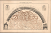

Les Pyrénées vues de Pau, l'observateur étant placé sur la tourelle du Boulevard du Midi.
Singular Map and View of the Pyrenees.
- Digital Map Information
- Suitable for large format printing
- Full resolution TIFF file
- ICC color profile embedded
- Delivered instantly via download link
Singular Map and View of the Pyrenees.
This is a striking 1890 map and bird's-eye view of the Pyrenees from the southern French town of Pau, prepared by J. Jérôme and Louis Eugène Lenfant. It presents the region as it became popular both as a destination for hikers and mountaineers and for religious pilgrims in the wake of the 1868 Marian apparitions at Lourdes.A Closer Look
This remarkable sheet combines a panoramic bird's-eye view appearing in an arc above a topographic map of the region. The view is drawn from the perspective of the Château de Pau (illustrated at the bottom-right), looking southwest over the Ousse River toward the peaks of the Pyrenees, which are identified with their elevations noted. The map covers a slightly wider region, including lands north, east, and west of Pau, as well as the area covered in the view, up to the Spanish border. It labels towns and traces roads, railways, and waterways, with elevation indicated by shading and annotation. Concentric circles emanate from Pau at 10-kilometer intervals. The coat of arms at the top-left is that of Pau; that at the top-right combines the coats of arms of several nearby towns in the Basses-Pyrénées département (now called Pyrénées-Atlantiques).Historical Context
Both the coat of arms of Pau and a statue in the town (illustrated at the bottom-left) celebrate Henri IV (1553 - 1610), who was born at the Château de Pau and later ruled as King of Navarre (1572 - 1610) and King of France (1589 - 1610) until his assassination, one of the most notable cases of patricide in European history. Though born a Catholic, Henri was raised as a Huguenot. He became a key figure in the Wars of Religion before reconverting to Catholicism as king to promote his own legitimacy and mitigate the destructive religious conflict. In 1598, he promulgated the Edict of Nantes, which effectively ended the Wars of Religion in France. However, it did not satisfy hardliners among both denominations, one of whom killed him in 1610.This background of religious violence is worth keeping in mind when considering the contemporary (late 19th century) religious landscape in France, dominated not by the battle between Catholics and Protestants, but between Catholics and the secular state, particularly in the realm of education. The late 19th and early 20th century saw a series of claimed Marian apparitions, in which the Virgin Mary miraculously appeared to children, not coincidentally the same constituency at the heart of the secular education debate. Perhaps the most famous instance of Marian apparition in this period occurred near Lourdes (near center-left), in a series of encounters between 'the Lady' and a sickly 14-year-old local girl, Bernadette Soubirous (who was posthumously beatified and canonized as a saint). The grotto where the apparitions were said to have occurred soon became a pilgrimage site for the faithful and remains one of the top international pilgrimage destinations for Roman Catholics.
Publication History and Census
This sheet was lithographed by J. Jérôme, with landscape engraving by Louis Eugène Lenfant, and was published in Paris by Jean Noël Monrocq. Very little is known about Lenfant (fl. c. 1864 - 1890) and even less about Jérôme, who may have been related to a Parisian lithographer surnamed Jérôme (fl. c. 1845 - 1860) listed in the online Dictionnaire des imprimeurs-lithographes du XIXe siècle. The altitudes were taken from a somewhat earlier, seminal map of the Pyrenees by mountaineer and expert on the region Paul Édouard Wallon (1821 - 1895). The sheet is undated, but can be dated to 1890 based on contemporary publication records (1890 editions of the Journal général de l'Imprimerie et de la Librairie and the Bulletin mensuel des récentes publications françaises). This work appears to be quite rare, only being cataloged at the Bibliothèque nationale de France and the David Rumsey Historical Map Collection / Stanford University, and with limited market history.Cartographer
Jean Noël Monrocq (December 25, 1819 - February 18, 1913) was a French printer and bookseller active in Paris in the mid to late 19th century. Monrocq was the son of a farmer, born on Christmas Day, hence his name, in Trelly, La Manche, France. In 1839, he moved to Paris for a more urban lifestyle. Although he had little formal education, he found work with the Parisian book and print seller Delarue. Meeting with success, he opened his own print shop in 1848. He initially applied for a bookseller's patent in 1853, but the application was initially rejected. It was formally approved in 1877. In 1859, he received a lithographer's patent for artistic and industrial prints for educational purposes. He took over the presses of Louis Etienne Stanislas Petit in 1859, but did not receive a formal intaglio imprint until 1865. In March 1874, he established a branch of his lithographic printing press in Ivry, Rue de Vitry, where he moved some of his equipment. He became known for zincographic lithography - the process of etching plates into zinc, which he falsely claimed to have invented. He did, nonetheless, contribute significantly to the industrialization of printing with zinc plates. Being of cheap materials, simple to make, and easy to modify, zinc plates became the standard for news printing. Zincography under Monrocq was also ideally suited to map production, and Monrocq produced a significant corpus of maps, spearheading the movement to centralize map production in France. The firm continued well after Monrocq's death, issuing maps for both Hachette Taride. For a time, his son, Léon Monrocq (1857 - 1902), worked with him, specifically printing maps, but tragically, he died young and did not inherit the business. The firm was taken over by the founder's son-in-law, who took the name Gaillac-Monrocq. Jean Noël Monrocq's grandson, Lucien Monrocq, eventually took over the business. Jean Noël Monrocq is interred in the family crypt at Paris's famous Père Lachaise Cemetery. Further Details...
Condition
Very good. Light toning.
References
Rumsey 16139.000. BnF Exemplaire : 220078 (1) (Fonds cartes et plans) Médiathèque intercommunale Pau-Pyrénées.