This item has been sold, but you can get on the Waitlist to be notified if another example becomes available, or purchase a digital scan.
1799 Vancouver Map of Southern Alaska and British Columbia
QueenCharlottePrinceofWales-vancouver-1799-2$1,000.00

Title
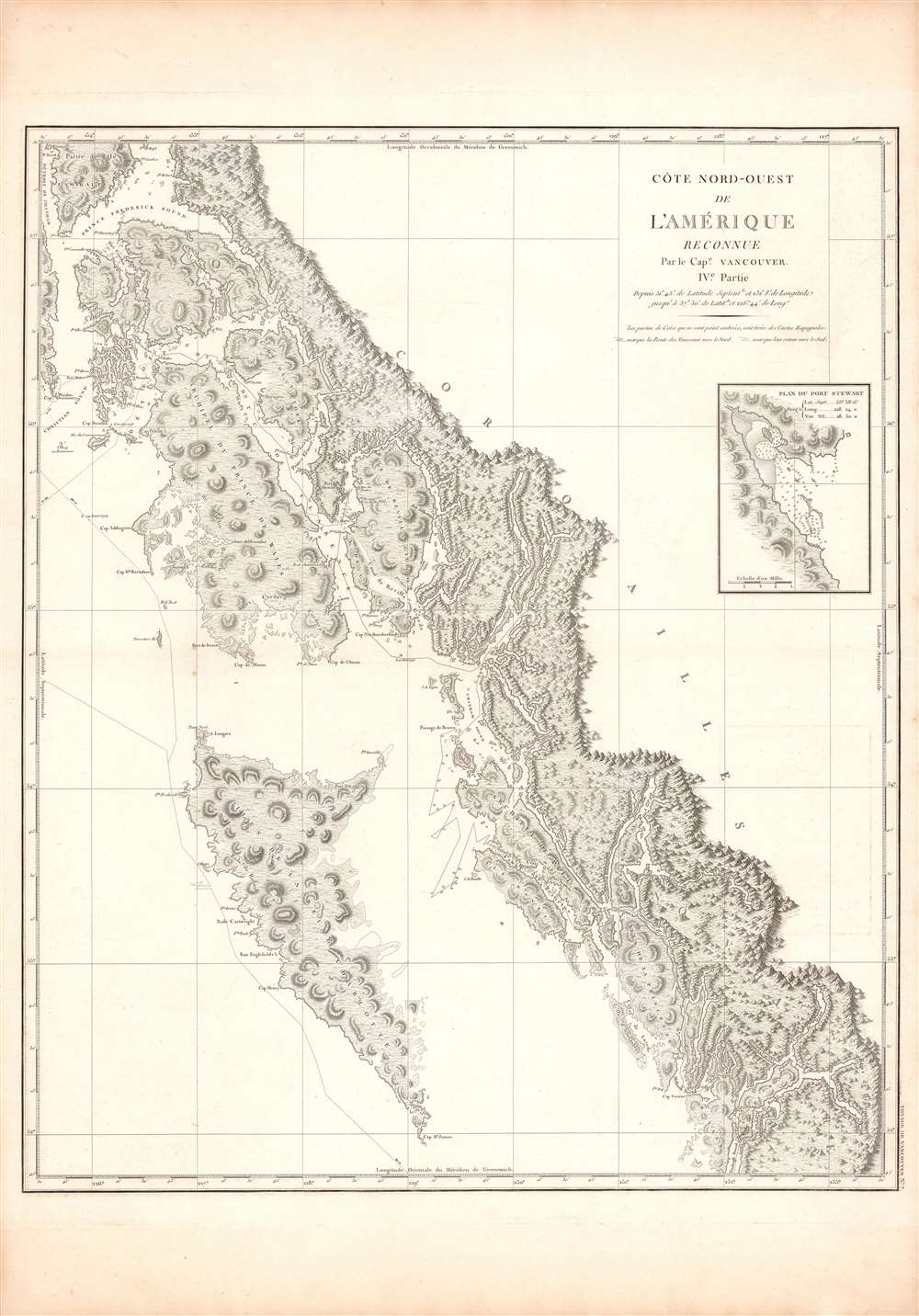
Cote Nord-Ouest de L'Amerique Reconnue par le Cape. Vancouver. IVe Partie.
1799 (undated) 29 x 24 in (73.66 x 60.96 cm) 1 : 1500000
1799 (undated) 29 x 24 in (73.66 x 60.96 cm) 1 : 1500000
Description
One of George Vancouver's most important and influential charts, this is a 1799 mapping of the coast from (Prince) Frederick Sound and Prince of Wales Island to Haida Gwaii (or the Queen Charlotte Islands), now on the border between Alaska and Canada. It was the first truly accurate and detailed reconnaissance of this forbidding coastline.
The goals of the expedition were both scientific and political. Vancouver was charged with precisely triangulating the locations of New Zealand and Australia, map the fur-rich Pacific Northwest for potential British settlement, and address unanswered questions from the final Cook Expedition (1776 - 1780) regarding Cook's Inlet and the possibility of a Northwest Passage.
In 1795, Vancouver returned to a Europe enmeshed in the French Revolutionary Wars (1792 - 1802). With the looming threat of Napoleon, Britain had little interest in science and discovery. Thus, despite his achievements, the great explorer was sidelined and besieged by personal and political enemies made during the voyage, including the expedition's naturalist Archibald Menzies (1754 - 1842) and the wastrel sailor Baron Thomas Pitt (1775 - 1804), who attempted to beat Vancouver down on the streets of London. By this time, the navigator's heath had also deteriorated and he died in 1798 of unknown causes.
A Closer Look
Queen Charlotte Island and Prince of Wales Island see their full shores mapped in detail for the first time. Vancouver's meticulous attention to detail was so effective that his maps of the northwest American coast continued to be the best available for nearly a century. Here, coastal features and hazards are charted and soundings are provided around Port Stewart and Chatham Sound. A line with dates traces the progress of Vancouver's ships. An inset is provided of Port Stewart, now part of the Ketchikan Gateway Borough of Alaska. These island as well as the adjacent coastal lands are the traditional home of the Haida and Tlingit peoples, known for their fine carving and distinctive tribal culture.Vancouver Expedition (1791 - 1795)
The Vancouver Expedition was an epic four-and-a-half-year circumnavigation of the globe combining exploration and diplomacy. The expedition, launched under the auspices of the British Royal Navy, was commanded by Captain George Vancouver (1757 - 1798). It is considered the last great voyage of discovery of the 18th century and the last major voyage to search for a Northwest Passage. En route, Vancouver painstakingly charted North America's northwestern Pacific Coast regions, including parts of Alaska, Washington, Oregon, and British Columbia. He also explored the Hawaiian Islands and the southwest coast of Australia.The goals of the expedition were both scientific and political. Vancouver was charged with precisely triangulating the locations of New Zealand and Australia, map the fur-rich Pacific Northwest for potential British settlement, and address unanswered questions from the final Cook Expedition (1776 - 1780) regarding Cook's Inlet and the possibility of a Northwest Passage.
In 1795, Vancouver returned to a Europe enmeshed in the French Revolutionary Wars (1792 - 1802). With the looming threat of Napoleon, Britain had little interest in science and discovery. Thus, despite his achievements, the great explorer was sidelined and besieged by personal and political enemies made during the voyage, including the expedition's naturalist Archibald Menzies (1754 - 1842) and the wastrel sailor Baron Thomas Pitt (1775 - 1804), who attempted to beat Vancouver down on the streets of London. By this time, the navigator's heath had also deteriorated and he died in 1798 of unknown causes.
Publication History and Census
This example of the map was issued as Plate No. 7 in the highly desirable 1799 French edition of Vancouver's atlas, which is noted for being more beautifully produced with better engraving, higher quality paper, and more detail than the 1798 English edition. None of the maps list an engraver, but the atlas's introductory text states that they were engraved at the Dépôt des Cartes et Plans de la Marine under the supervision of Jean-Nicholas Buache de Neuville. The French edition of Voyage de découvertes is well represented in institutional collections. However, we see examples of the separate chart cataloged only in the Biblioteca Nacional de España, the Anchorage Museum, and the University of Michigan.Cartographer
George Vancouver (June 22, 1750 - May 10, 1798) was a British naval officer and explorer active in the late 18th century. Vancouver was the last of the great naval explores of the 18th century and, along with Captain James Cook and Perouse, is credited with the first accurate mapping of the Northwest Coast of America. Vancouver was born in King's Lynn, England and joined the Royal Navy at age 13 as a seaman. While little is known of Vancouver's early life, he first appears in the annals of history as a midshipmen aboard the HMS Resolution of Captain Cook's second voyage in search of Terra Australis. On this expedition Vancouver claimed to have "been nearer the south pole than any other man" (after climbing the bowsprit before the ship turned back in the face of mountains of Antarctic ice). He also accompanied the third Cook expedition as a midshipman on the HMS Discovery where he witnessed the discovery of the Hawaiian Islands as well as Cooks tragic death on those same islands. Returning to England under Cook's second, Captain Clerke recommended Vancouver for promotion to Lieutenant. Under his new commission he spent several years learning surveying in the Caribbean aboard the HMS Martin, where he also distinguished himself in a number of military altercations with the French. In 1790 Vancouver received an appointment as the Captain of the HMS Discovery and was commissioned to complete the exploration of American's Northwest Coast begun by Cook and Perouse. Between 1791 and 1795 Vancouver's remarkable diligence and attention to detail created the first truly accurate cartographic picture of the American Coast between San Francisco Bay and California. Vancouver was the first to map countless rivers and inlets and to identify Vancouver Island. During his four years of exploration he also spent three winters in Hawaii, creating in the process the first accurate map of the islands. Unlike many earlier explorers Vancouver generally maintained good and respectful relations with the indigenous peoples he encountered. In Hawaii Vancouver allegedly negotiated the cession of Hawaii to England as well as introduced beneficial flora and fauna to the archipelago. Vancouver returned to England in 1795 where he immediately ran afoul of the powers that be. During his voyages Vancouver excited the ire of more than one crew member, including the well-connected naturalist Archibald Menzies, the sailing master Joseph Whidbey, and Thomas Pitt, the powerful Baron of Camelford. Slandered and assaulted by these influential enemies, one of Britian's greatest explorers fell into obscurity. He died shortly after in 1798 and was buried in an unremarkable grave at St. Peter's Churchyard, Petersham, Surrey, England. The journals of Vancouver's expedition, as well as his all-important maps, were published posthumously in the same year as his death. Robin Fisher, the academic Vice President of Mount Royal University in Calgary and author of two books on Vancouver, writes: He [Vancouver] put the northwest coast on the map...He drew up a map of the north-west coast that was accurate to the 'nth degree,' to the point it was still being used into the modern day as a navigational aid. That's unusual for a map from that early a time.
Today Vancouver is memorialized by Vancouver Island, which he discovered, the Hudson Bay Company's Fort Vancouver, the city of Vancouver, Vancouver Peninsula Australia, Mount Vancouver, the 8th highest mountain in Canada, Vancouver Bay in Jervis Inlet, and the Vancouver Maritime Museum. For his 250th birthday, the Canada Post issued a special postage stamp in his honor. More by this mapmaker...
Source
Baker, J., and Vancouver, G., Voyage de decouvertes a l'ocean Pacifique du Nord, et autour du monde, (Paris: Imprimerie de la République) 1799.
Condition
Very good.
References
Rumsey 0233.008 (1828 reissue). OCLC 877854825, 1135311798.