This item has been sold, but you can get on the Waitlist to be notified if another example becomes available, or purchase a digital scan.
1752 Ulloa and Juan Map of the Andes in Ecuador
QuitoMeridian-ulloa-1752$550.00

Title
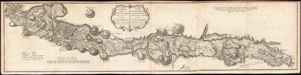
Carte de la Meridiene mesurée au Royaume de Quito; Par ordre du Roy notre Souverain pour parvenir à la Connoissance du Dégré Teirestre et de la figure de la teire par D. Jorge Juan et D. Ant. de Ulloa en 1744./ Karte von der gemessenen Mittagslinie in dem Koenigreiche Quito Auf Befehl Sr. Koenigl. Majest. in Spanien zur Erkentniss des rechten Gehalts eines Erdgrades und der Gestalt der Erde von dem Hrn Georg Juan und dem Hrn Antonio de Ulloa im Jahre 1744 zu Stande gebracht.
1752 (dated 1744) 9.5 x 39.5 in (24.13 x 100.33 cm) 1 : 400000
1752 (dated 1744) 9.5 x 39.5 in (24.13 x 100.33 cm) 1 : 400000
Description
This is a rare, 1752 map of Ecuador's La Sierra region, from Carchi Province in the north to Cañar Province in the south. It encompasses one full degree of arc along the Quito meridian, and represents the first scientific survey of this high Andes valley. It appeared in the 1752 French and German editions of Antonio de Ulloa and Jorge Juan's Relacion Historica del Viaje a la America Meridional, a landmark work of South American geography, culture, history and science produced to report the two scientist's labors for the French Geodesic Mission, which were carried out in what is modern Ecuador over ten years. Specifically, the map shows the triangulations performed by Juan (his work indicated by solid lines) and Ulloa (dotted lines) during the expedition. It mapped Ecuador's Central Valley with unparalleled precision, marking rivers, towns and major peaks from El Angel, to Quito, to El Tambo. Towns of various sizes are differentiated with a key; relief is shown in hachure. Forests and plains are shown pictorially. Roads are marked with a dotted line, and bridges over rivers are indicated as well.
Goals of the The French Geodesic Mission: Earth! Just How Round Is It, Anyway?
Led by Charles Marie de La Condamine, the Geodesic Mission was intended to determine whether Newton's theory on the oblate nature of the globe - that it was not truly spherical, but slightly flattened at the poles (narrower from pole to pole than across the equator). Scientists disagreed: Cassini, for example, theorized that the distance was greater at the poles. To resolve the issue, it would be necessary to measure a degree of arc near the Equator, measure a degree of arc nearer the North Pole, and compare the two. Condamine's part of the project was to survey a measurable length of a meridian along the equator. This required that Condamine and his colleagues precisely survey a length of the high valleys of the Andes - literally the only place in the world where such a survey was practicable in the 1730s. Ultimately, the project determined that the Earth is indeed not perfectly spherical but is oblate, i.e. flattened at the poles - as per NewtonPublication History and Census
This map appeared in Voyage historique de l'Amérique méridionale fait par ordre du roi d'Espagne, published in Amsterdam and Leipzig in 1752 in what appears to have been a single edition. (The map in the 1748 Spanish edition was a different engraving altogether.) The volume is catalogued in only four institutional collections according to OCLC, and the separate map is held only by the Sachische Landesbibliothek and the ETH-Bibliothek in Zurich. The map is scarce on the market, having been catalogued only four times since 1987.CartographerS
Antonio de Ulloa y de la Torre-Giral (January 12, 1716 – July 3, 1795) was a Spanish general of the navy, explorer, scientist, author, astronomer, colonial administrator and the first Spanish governor of Louisiana. He took part in the French Geodesic Mission in present-day Ecuador. During this expedition and in conjunction with his colleague Jorge Juan, he discovered the element platinum, and was the first person to write a scientific description of the new metal. In 1748 he published an account of the people and countries he had encountered during the French Geodesic Mission. He was a Fellow of the Royal Society and a foreign member of the Royal Swedish Academy of Sciences. He is credited with the establishment of the first museum of natural history, the first metallurgical laboratory in Spain, and the observatory of Cadiz. More by this mapmaker...
Jorge Juan y Santacilia (January 5, 1713 - June 21, 1773) was a Spanish mathematician, scientist, naval officer, and mariner. In collaboration with the French Geodesic Mission, he confirmed Newton's theory that the Earth is not perfectly spherical but is oblate, i.e. flattened at the poles. Juan also successfully measured the heights of the mountains of the Andes using a barometer. In 1749, he was sent to England to spy on British naval construction techniques, and was successful to the extend of bringing back to Spain with him fifty British naval constructors - many of whom would build the Spanish ships that would later fight the British in the American Revolutionary War and the battle of Trafalgar. Learn More...
Charles Marie de La Condamine (January 28, 1701 – February 4, 1774) was a French explorer, geographer, and mathematician. He was a contemporary and friend of Voltaire, with whom he successfully gamed the French lottery. He took part in the French Geodesic Mission, tasked with performing measurements near the equator in order to test Newton's theory regarding the oblate shape of the globe. In conjunction with similar measurements performed by an expedition to Lapland, by Maupertuis, Clairaut, and Le Monnier, the Geodesic Mission was able to declare Newton's theory correct. This project resulted in the first map of the Amazon region based on astronomical observation. (Condamine also produced, based on experiences in this journey, the first scientific paper on the properties of rubber.) Learn More...
Source
Juan y Santacilia, J. and; de Ulloa, A. Voyage historique de l'Amérique méridionale fait par ordre du roi d'Espagne (Amsterdam and Leipzig, chez Arkstée & Merkus) 1752.
Condition
Very good condition. Printed to three sheets and joined as issued. Few creases at folds. Margin trimmed close at top.
References
OCLC 732263514. cf. Shirley (BL Atlases) G.ULL-1a #5.