This item has been sold, but you can get on the Waitlist to be notified if another example becomes available, or purchase a digital scan.
1831 Becher and Murray Map of the Niger River, Nigeria
Quorra-murray-1831$175.00

Title
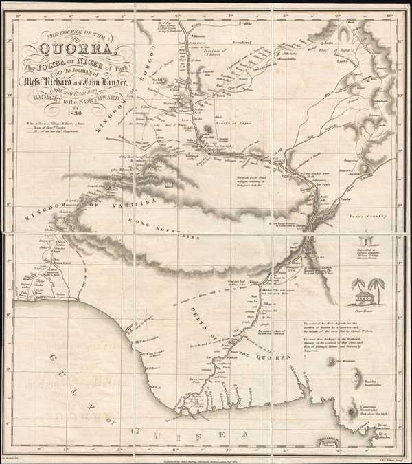
The Course of the Quorra, the Joliba or Niger of Park from the Journals of Messrs Richard and John Lander, with their Route from Badagry to the Northward in 1830.
1831 (dated) 12.375 x 11.25 in (31.4325 x 28.575 cm) 1 : 2880000
1831 (dated) 12.375 x 11.25 in (31.4325 x 28.575 cm) 1 : 2880000
Description
This is an 1831 Alexander Bridport Becher and John Murray map the course of the Niger River in Nigeria. The map, solidly in the tradition of early 19th century European maps of Africa, depicts the Niger River and the route followed by the expedition led by Richard and John Lander and Hugh Clapperton (with the intended goal of traveling down the Niger to its mouth), while details and notations in the surrounding regions are scarce. The Lander's expedition began on the Atlantic coast at the town of Badagry and moved inland. Numerous locations along their route are labeled, some of which are even dated. Notations, such as 'many ruins', 'rocky barrier', and 'many villages and much cultivation' dot the map, allowing for some understanding of observations made by expedition members. Others recount events suffered by the expedition, including 'attacked by war canoes and taken to Kirree' and 'compass lost at Kirree 5 Nov'. Other notations imply the sense of unknown surrounding areas where Europeans had not been, as two branches of the Niger are labeled, 'branch said to run to Benin' and 'said to run to S.E.'. Two small vignettes are drawn along the right border. One illustrates a local hut, called by a different name in each local language and the second illustrates an Eboe house.
Both Richard and John Lander returned from the 1830 expedition. John never returned to Africa and upon his return in 1832 began working as a custom house official in Liverpool and later London through the patronage of Lord Goderich, who was the president of the Royal Geographical Society. Due to his extensive accomplishments as an explorer, Richard Lander was the first winner of the Royal Geographical Society Founder's Medal in 1832. Later that year, Richard returned to Africa to help establish a trading settlement at the junction of the Niger and Benue rivers. On this expedition, Lander's party suffered many difficulties, including the death of several personnel due to fever. Lander, while traveling upstream in a canoe, was attacked by locals and wounded in the thigh by a musket ball. He would later die from his injury.
This map was drawn by Alexander Bridport Becher, engraved by the firm of John and Charles Walker, and published by John Murray in the Geographical Journal in 1831.
CartographerS
John Murray I (1737 - 1793) founded the British publishing firm John Murray (1768 - present) in London. Born in Edinburgh, Murray served as an officer in the Royal Marines and built a list of authors that included Isaac D’Israeli and published the English Review. Murray the elder also was one of the founding sponsors of the London evening newspaper The Star in 1788. John Murray II (November 27 1778 - June 27, 1843) continued the family publishing business and developed it into one of the most important and influential publishing houses in Britain. The list of authors published by the firm grew to include Jane Austen, Sir Walter Scott, Washington Irving, George Crabbe, and Lord Byron under his tenure. Murray II also moved the business to 50 Albermarle Street in Mayfair, which became famous for Murray’s tradition of ‘four o’clock friends’, which was afternoon tea with his writers. John Murray III (1808 - 1892) continued to grow the business, and the firm published the first English translation of Goethe’s Theory of Colours, David Livingstone’s Missionary Travels and Charles Darwin’s Origin of Species during his tenure. Murray also published Herman Melville’s first two books. The firm began publishing Murray Handbooks in 1836, an ancestor of all modern travel guides. Sir John Murray IV (1851 - 1928) was publisher to Queen Victoria. Three successive Murray’s after Murray IV led the business until it was purchased by Hodder Headline in 2002, which was acquired by the French conglomerate Lagardère Group in 2004. Today, Murray is an imprint of Lagardère under the imprint Hachette UK. More by this mapmaker...
Alexander Bridport Becher (June 12, 1796 - 1876) was hydrographer, cartographer, author, and Rear Admiral in the Royal Navy. He entered the Royal Navy College in April 1810 and graduated with a commission as a Midshipman in 1812. He served with Commodore Edward Owen and Captain William Fitzwilliam Owen from December 1814 until June 1817 surveying lakes in Canada. During the course of his career in the Navy, Becher served in many different capacities on several ships and undertook survey missions in the North Sea and the Orkney Islands. When not aboard ship, Becher was employed by the Hydrographic Department of the Admiralty, where he served from May 1823 until 1864. During his time at the Hydrographic Department, Becher arranged and classified the Department's original charts, which numbered between 20,000 and 30,000 in a system that rendered them accessible for immediate reference. Becher also laughed the Nautical Magazine in 1832, which he managed and edited for the subsequent 39 years. Learn More...
John Walker (1787 - April 19, 1873) was a British map seller, engraver, lithographer, hydrographer, geographer, draughtsman, and publisher active in London during the 19th century. Walker published both nautical charts and geographical maps. His nautical work is particularly distinguished as he was an official hydrographer for the British East India Company, a position, incidentally, also held by his father of the same name. Walker's maps, mostly published after 1827, were primarily produced with his brothers Charles Walker and Alexander Walker under the imprint J. and C. Walker. Among their joint projects are more than 200 maps for the influential Society for the Diffusion of Useful Knowledge Atlas (SDUK). In addition they published numerous charts for James Horsburgh and the British Admiralty Hydrographic Office, including Belcher's important map of Hong Kong and Carless' exploratory map of Karachi. The J. and C. Walker firm continued to publish after both Walkers died in the 1870s. Learn More...
Condition
Very good. Even overall toning. Dissected and mounted on linen. Blank on verso.
References
OCLC 221407697.