
1982 Railway Publishing House Schematic of China's Rail System

This item has been sold.
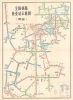
全国铁路营业站示意图 (货运) / Map of Railway Operating Stations Nationwide (Freight).
Rail Power of the People's Republic.
Choose a Collection:
This Item
Enquire
Rail Power of the People's Republic.
This is a wonderful 1982 schematic map of the Chinese freight rail system, published by the Chinese Railway Publishing House. The map falls in the tradition of Harry Beck's London Underground map or the Massimo Vingelli New York City Subway map, which are, in essence, more itinerariums or infographics than maps, displaying points in a system and how to get there, but are not geographically accurate or only loosely so.A Closer Look
The 'map' very roughly corresponds to the geography of China, with different lines labelled and their stations noted, with a red star at center-top marking Beijing. The lines are organized into regional bureaus (局), such as the Urumqi Bureau (乌鲁木齐局) handling shipment in Xinjiang, and color-shaded accordingly. In some cases, bureaus are defined roughly by provincial boundaries, but in any event are organized around cities serving as freight hubs (marked with double circles), such as Urumqi, Lanzhou, Xi'an, and Wuhan. These bureaus are subdivided into offices (办事处), as with the Urumqi and Hami Offices of the Urumqi Bureau.Many stations are followed by a character in brackets, explained at bottom-right, with the characters noting their limitations. For instance, some stations do not handle explosive or dangerous goods, while others do not handle livestock. Despite being a schematic of the freight rail system, the map also notes some intermediary stations unable to handle freight. The explanation box at bottom-right also indicates the marking for lines that are under construction, lacking a license to operate, or on a different (meter) gauge, most railways in China using standard gauge. The entirety of the railways of 'Taiwan Province' at bottom-right are recorded as lacking a license to operate (不办理营业线).
Railroads in China
The first railway to be built in China was a 600-metre narrow gauge demonstration line that a British merchant assembled in Beijing in 1864 in hopes of securing a national contract from the Qing government. The Emperor was unimpressed and ordered the railroad disassembled. The next effort, again by the British, was built in 1876 without Qing approval between Shanghai and Woosung (Baohan, Shanghai). Following the First Sino-Japanese War (1894 - 1895), the Qing began to recognize the advantage of railroads, and modern technology in general, and began granting construction contracts. Railroad construction continued throughout the remaining years of the Qing Dynasty and during the Republic of China Period (1912 - 1949). During the Second Sino-Japanese War (1839 - 1945), Japanese companies also built numerous railroads in the occupied territories. After the establishment of the People's Republic of China in 1949, the new government under Mao Zedong invested heavily in the railway network. From the 1950s to the 1970s, railroad lines throughout the country were dramatically expanded, and in recent decades China has become a global leader in railroad construction, including high-speed rail. However, this map was produced early on in China's 'Reform and Opening Up' period, when rail construction slowed somewhat as the frenetic pace of the Maoist period, often driven by military or political rather than econmic logic, abated.Publication History and Census
This map was edited by the Freight Department of the Railway Ministry (铁道部货运局) and published by the Chinese Railway Publishing House (中国铁道出版社) in March 1982. Variations of this map were issued from about 1950 onwards, each exhibiting the increasing complexity of China's railroad network. Though printed in a run of 150,000, these were ephemeral products and not intended for long-term preservation, meaning a relative handful survive. The OCLC notes examples of a 1980 map with this title (though seemingly not focused on freight rail) at Stanford University and Princeton University (OCLC 1063794378.), but no examples from 1982.Condition
Good. Wear and toning on old fold lines.