1881 American Publishing Pictorial Game Map of the United States
RamblesUSA-americanpublishing-1881$3,950.00


Title
Rambles throughour Country. An Instructive Geographical Game for the Young.
1881 (dated) 24.5 x 34 in (62.23 x 86.36 cm) 1 : 6842880
1881 (dated) 24.5 x 34 in (62.23 x 86.36 cm) 1 : 6842880
Description
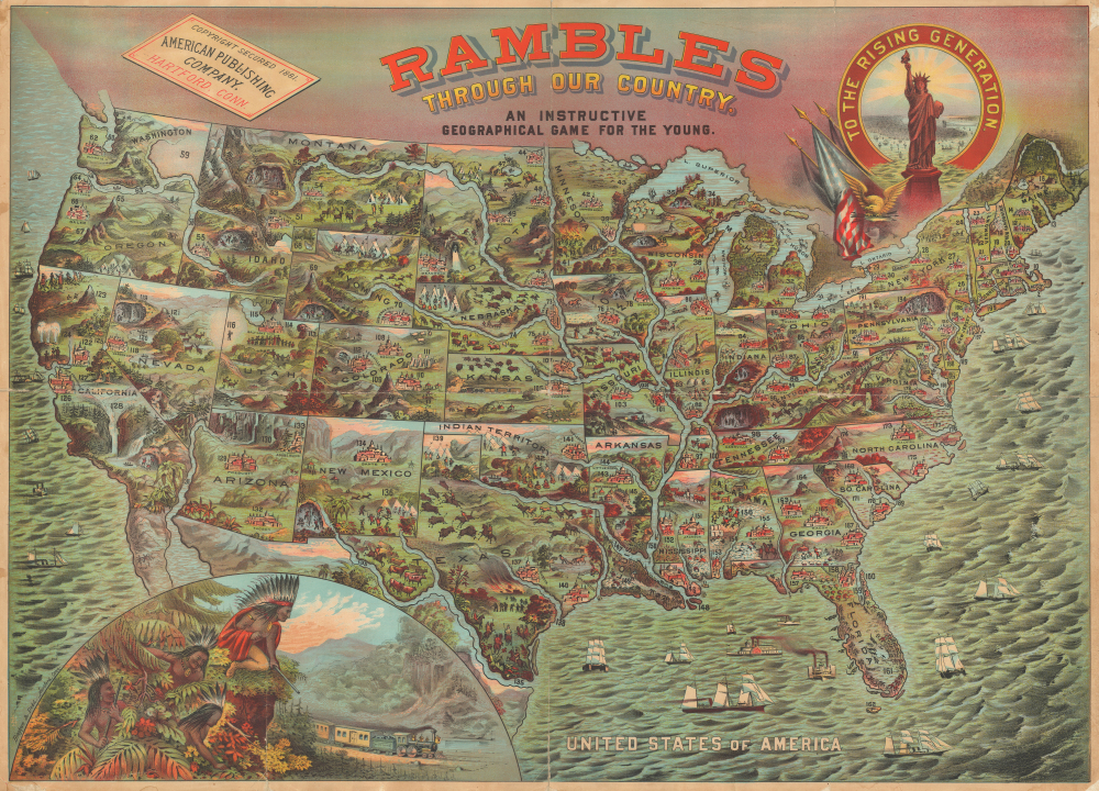
A 1881 first-edition example of Bingham and Dodd's spectacular chromolithograph game board map of the United States, published by the American Publishing Company, Hartford, Connecticut. Here, accompanied by its original instructions. This is the most impressive game map published in the United States in the 19th century. The map beautifully celebrates American exceptionalism, the cultural and geographical diversity of the country, and the westward Expansion.
The game is designed to educate and encourage patriotism - given the lavish nature of the production, we can only assume it was intended for the children of the wealthy. Gameplay involved a 'teetotum', a spinning top with numbered facets that would guide players through the map. There are some 200 numbered locations illustrated, starting at Hartford, where the game was published, and concluding at New York City, with at least three stops in each state and territory. When landing on a numbered site, players are encouraged to consult the accompanying booklet, which offers short entries on each.
There can be little doubt that this game was inspired by the work of British Game maker William Wallis in the 1840s, who issued two comparable pieces: Star-Spangled Banner and Wanderers in the Wilderness (Geographicus: wanderersinthewilderness-wallis-1844). Both the design and gameplay are remarkably similar, though Rambles is arguably a grander and more elaborate production on all levels.
A Closer Look
The map is a striking 7-color cromolithograph - that means seven separate plates had to be prepared, one for each color, and registered with exacting precision to achieve this remarkable composite effect. Coverage embraces the United States as it existed in 1881. It is replete with rich illustrations of American cities, people, geography, flora, and fauna. The surrounding waters are teaming with maritime life. The authors emphasize the boundless potential of the United States, particularly the western states, where there is an emphasis on mining and natural wonders. American Indians are represented throughout, more often than not as a threat to American progress - for example, the group lying in ambush as a train passes in the lower left.The game is designed to educate and encourage patriotism - given the lavish nature of the production, we can only assume it was intended for the children of the wealthy. Gameplay involved a 'teetotum', a spinning top with numbered facets that would guide players through the map. There are some 200 numbered locations illustrated, starting at Hartford, where the game was published, and concluding at New York City, with at least three stops in each state and territory. When landing on a numbered site, players are encouraged to consult the accompanying booklet, which offers short entries on each.
There can be little doubt that this game was inspired by the work of British Game maker William Wallis in the 1840s, who issued two comparable pieces: Star-Spangled Banner and Wanderers in the Wilderness (Geographicus: wanderersinthewilderness-wallis-1844). Both the design and gameplay are remarkably similar, though Rambles is arguably a grander and more elaborate production on all levels.
Chromolithography
Chromolithography, sometimes called oleography, is a color lithographic technique developed in the mid-19th century. The process uses multiple lithographic stones, one for each color, to yield a rich composite effect. Generally, a chromolithograph begins with a black basecoat upon which subsequent colors are layered. Some chromolithographs used 30 or more separate lithographic stones to achieve the desired effect. Chromolithograph color can be blended for even more dramatic results. The process became extremely popular in the late 19th and early 20th centuries when it emerged as the dominant method of color printing. The vivid color chromolithography made it exceptionally effective for advertising and propaganda.Publication History and Census
This chromolithograph game board map was published in 1881 by the American Publishing Company, based in Hartford, Connecticut. The present example is the first edition. The game remained in publication until at least 1890, and there are at least three states:- 1881 - First state. Bingham and Dodd imprint in the lower left.
- 1886 - Second state. Statue of Liberty dated 1886; Dodd imprint.
- 1890 - Third State. Imprint changed to Schaeffer and Weisenbach, New York; Dakota divided; date on the Statue of Liberty updated to 1890; copyright date in the upper left also updated to 1890.
CartographerS
William H. Dodd (May 25, 1826 - February 20, 1914) was a Hartford, Connecticut based lithographer and publisher. He operated the firm Bingham and Dodd with John H. Bingham (1831 - 1910) from 1860 until 1884 and then started his own firm, William H. Dodd and Company, which operated in Hartford until around 1910. More by this mapmaker...
John Henry Bingham (March 7, 1831 - June 10, 1910) was an American lithographer. Born in New York, Bingham and John Kelley formed the partnership Bingham and Kelley which was active in 1857 and 1858. Bingham then went into business with William H. Dodd in 1860 in Hartford. In 1861, Bingham, Dodd, and Company advertised in the Hartford, Connecticut City Directory, stating that they printed labels for druggists and perfumers, views of buildings, portraits, and landscapes from nature as well as 'engravings on stone, of checks, notes, bill heads, certificates of stock, circulars, maps, charts, etc.'. That partnership lasted until 1884. By 1900, he and his family then moved to Chicago, where he continued to work as a lithographer. He married Anna Maria Ehret (1835 - 1909) on February 19, 1854, with whom he had thirteen children. Learn More...
American Publishing Company (1865 - 1903) was a Hartford, Connecticut-based publishing house. The firm was founded by Elisha Bliss (October 13, 1821 - September 28, 1880). Bliss was one of the first to recognize the genius of Samuel Clemens (Mark Twain) and, in 1867, encouraged the young journalist to write for him. Spurred by the popularity of Twain's writings, the American Publishing Company rose quickly in prominence, publishing many important works. When Elisha Bliss died in 1880, the firm was taken over by his sons, Francis Edward 'Frank' Bliss (1843 - 1915) and Walter Bliss (1858 - 1917). The firm, like many publishers of the period, operated on a subscription basis with door-to-door salesmen taking orders for delivery at a later date. Their most lucrative production was a 1898 uniform edition of Mark Twain's works. In 1903, the American Publishing Company was acquired and absorbed into Harper and Brothers. Learn More...
Condition
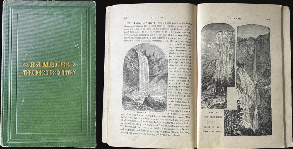
Good. Wear on old fold lines. Backed with original publisher's linen. Accompanies instruction booklet.
References
Rumsey 3886.000. Hornsby, S. J., Picturing America: The Golden Age of Pictorial Maps, pages 5, 7. Huntington Library, Jay Last Collection, priJLC_SPO_005003.