1965 Army Map Service Intelligence Map of Ras Tanura, Saudi Arabia and Environs
RasTanuraTerrain-ams-1965$1,500.00


Title
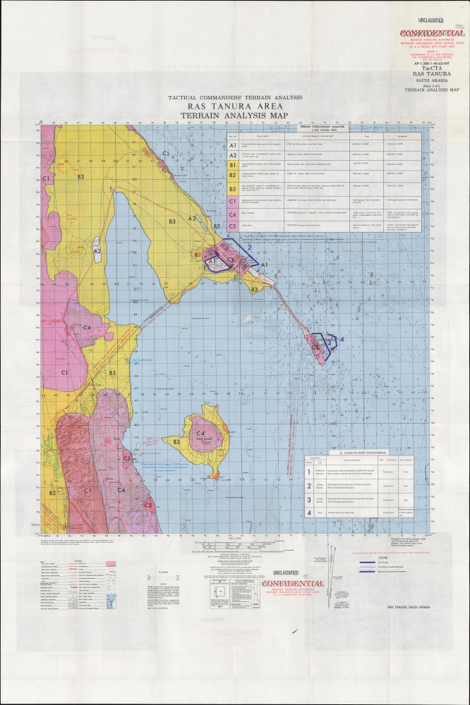
Tactical Commanders' Terrain Analysis Ras Tanura Area Terrain Analysis Map AP-1-380-46-65-INT. TacCTA Ras Tanura Saudi Arabia.
1965 (dated) 36.25 x 28 in (92.075 x 71.12 cm) 1 : 50000
1965 (dated) 36.25 x 28 in (92.075 x 71.12 cm) 1 : 50000
Description
This is a 1965 Tactical Commanders' Terrain Analysis (TacCTA) map of Ras Tanura, Saudi Arabia, prepared by the Army Map Service for the Defense Intelligence Agency. The area is home to a large Saudi Aramco oil refinery and port, the main avenue for Saudi Arabia's oil exports, and the map would have been vital for any military operation that might take place there.
The present map reflects the assiduousness of the agency's work, with granular detail and analysis that would be critical in any military operation at Ras Tanura. Given the importance of Ras Tanura for global oil supply and the highly unsettled state of regional politics (including a dispute within the Saudi monarchy between King Saud and his half-brother Faisal, who deposed the former in 1964) set against the background of the Cold War (1947 - 1991), one can imagine that this map would have been essential for safeguarding the Aramco facilities at Ras Tanura in the event of a military conflict.
CASOC/Aramco also built a relatively luxurious residential compound near the refinery at Najmah (Nejma here) for American workers, which has in the decades since come to house a more cosmopolitan mix of employees, including many Saudis. The adjacent town of Rahima (Rahaima here) historically housed Saudi and other non-Western workers, though these divisions were not always absolute. Other nearby facilities, such as a hospital and golf course, and the neighborhood of Radwah, are also part of this general residential area of the city. The Italian Camp to the south of the refinery was built to house some 1,700 Italian workers recruited from Eritrea at the end of World War II.
A Closer Look
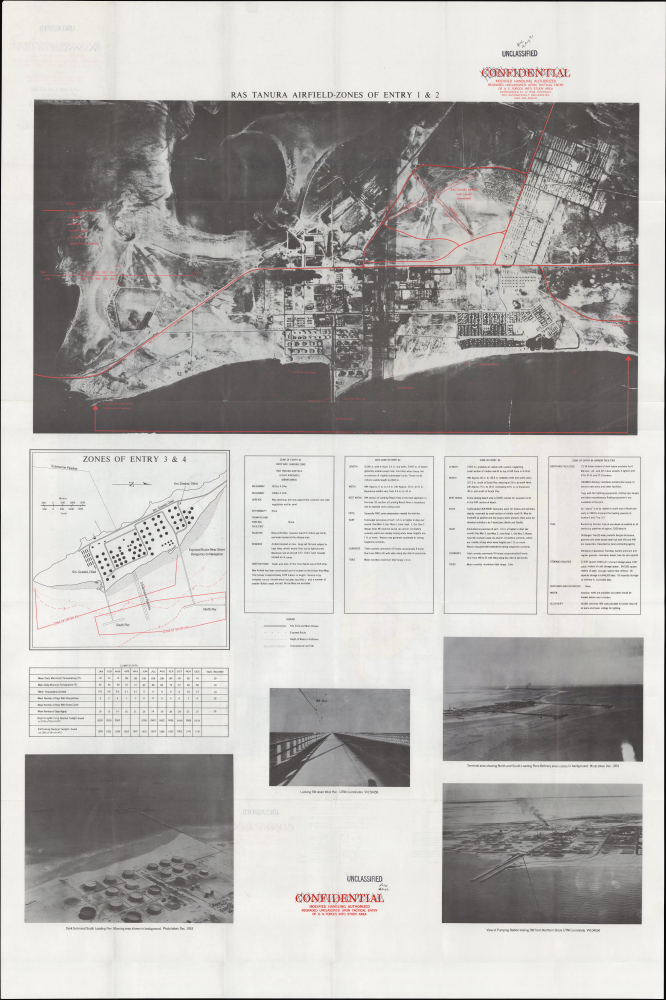
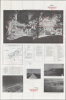
This map covers Ras Tanura and environs on the east coast of Saudi Arabia. A grid overlies the map, dividing it into squares of 100,000 meters, as explained in the diagram at the bottom. Color-shading and a series of numbers and letters are used to indicate the nature of terrain, its suitability for trucks and tanks, and the level of cover and concealment (generally very little). A similar table at the bottom-right gives related information for airstrips, beaches, and piers, which would be essential in any military operation. (The most favorable landing sites are marked in blue around the refinery and adjacent settlements.) Additional information on roads, terrain, flora, settlements, and human-built structures such as mosques, cemeteries, and wells is indicated according to the legend at bottom-left. As on land, remarkably detailed information is provided on the waters around Ras Tanura, including soundings, bottoms, and the location of fishing weirs. The verso provides additional information and photographs, focusing on the refinery and potential landing zones for ships and airplanes.Mapping Military Intelligence
This map was produced by the Defense Intelligence Agency (DIA), created in 1961 and housed within the Department of Defense under the leadership of the Under Secretary of Defense for Intelligence. The agency is thus independent of both the military services (whose intelligence outfits it took over many functions from) and the Central Intelligence Agency. The DIA is tasked with providing intelligence information to the Secretary of Defense, Joint Chiefs of Staff, and military commanders.The present map reflects the assiduousness of the agency's work, with granular detail and analysis that would be critical in any military operation at Ras Tanura. Given the importance of Ras Tanura for global oil supply and the highly unsettled state of regional politics (including a dispute within the Saudi monarchy between King Saud and his half-brother Faisal, who deposed the former in 1964) set against the background of the Cold War (1947 - 1991), one can imagine that this map would have been essential for safeguarding the Aramco facilities at Ras Tanura in the event of a military conflict.
Ras Tanura and the Oil Industry
Ras Tanura is a settlement set on a peninsula jutting out into the Persian Gulf, located between Bahrain and Kuwait, forming the top portion of Tarut Bay. Its history is closely tied to the oil industry as it is home to major refinery and port facilities. When large quantities of oil were first discovered at nearby Dammam in 1938, the California Arabian Standard Oil Company (CASOC), forerunner to Saudi Aramco, built a pipeline to Ras Tanura, and a refining plant was put into operation. During World War II (1939 - 1945), a new, wider pipeline and a much larger refinery were constructed to support the war effort. Export capacity continued to expand, reaching 1 million barrels per day in 1971 and roughly 6 million barrels per day nowadays, some 90% of Saudi Arabia's oil exports, making Ras Tanura the largest oil port in the world.CASOC/Aramco also built a relatively luxurious residential compound near the refinery at Najmah (Nejma here) for American workers, which has in the decades since come to house a more cosmopolitan mix of employees, including many Saudis. The adjacent town of Rahima (Rahaima here) historically housed Saudi and other non-Western workers, though these divisions were not always absolute. Other nearby facilities, such as a hospital and golf course, and the neighborhood of Radwah, are also part of this general residential area of the city. The Italian Camp to the south of the refinery was built to house some 1,700 Italian workers recruited from Eritrea at the end of World War II.
Publication History and Census
This map was prepared by the Army Map Service in 1962, compiling information from somewhat earlier maps, and then was reprinted with the intelligence information overprint in 1965 for the DIA. It is part of a set of two maps, the other being Sheet 1, 'Ras Tanura Urban Area Map,' also offered by us. Originally marked 'confidential,' the maps were declassified in August 1991 (after the conclusion of the Gulf War). We are only aware of one other example of this map, held by the Library of Congress.Cartographer
The Army Map Service (AMS) (1941 - 1968) was the military cartographic agency of the U.S. Department of Defense and part of the U.S. Army Corps of Engineers. The AMS compiled, published, and distributed military topographical maps and other related materials for use by the U.S. Armed Forces. They also prepared maps for space exploration, intelligence reports, and the establishment of world geodetic control networks. Formed during World War II, by the end of the war the Army Map Service had prepared 40,000 maps. 3,000 different maps were created for the Normandy invasion alone. The AMS was instrumental in the Korean War and the Vietnam War, and during all three of these conflicts distributed tens of millions of maps to U.S. servicemen. On September 1, 1968, the AMS was resdesignated the U.S. Army Topographic Command, and continued under this name as an independent organization until January 1, 1972 when it was merged with the new Defense Mapping Agency and renamed the DMA Topographic Center. The Defense Mapping Agency was added to the National Imagery and Mapping Agency on October 1, 1996, which was redesigned the National Geospatial-Intelligence Agency in 2003. More by this mapmaker...
Condition
Very good. Light wear along original fold lines.
References
OCLC 863297964.