This item has been sold, but you can get on the Waitlist to be notified if another example becomes available, or purchase a digital scan.
1794 Laurie and Whittle Nautical Map of the Red Sea
RedSea-lauriewhittle-1794$475.00

Title
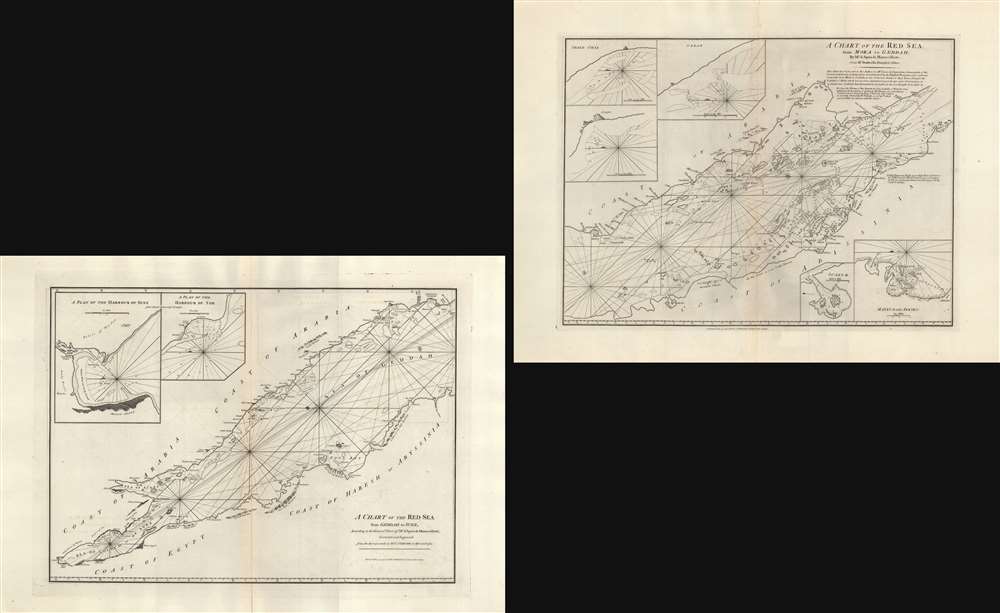
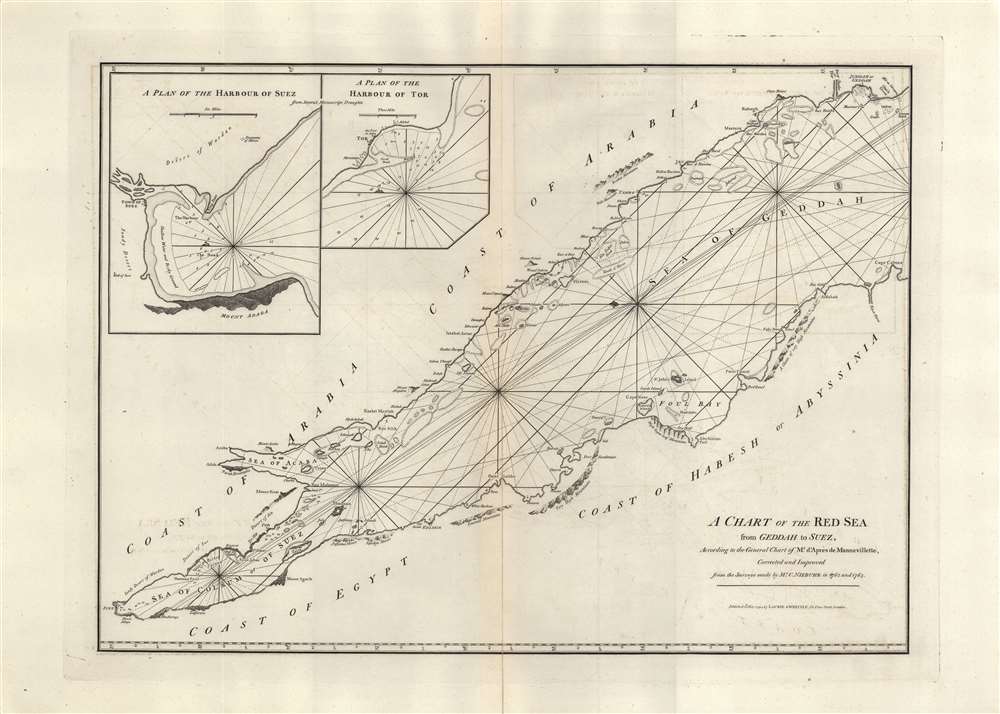
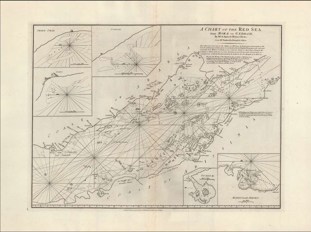
A Chart of the Red Sea from Geddah to Suez. / A Chart of the Red Sea from Moka to Geddah.
1794 (dated) 23.5 x 32.75 in (59.69 x 83.185 cm) 1 : 1700000
1794 (dated) 23.5 x 32.75 in (59.69 x 83.185 cm) 1 : 1700000
Description
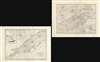
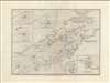
A set of 1794 nautical maps of the Red Sea by the British publishers Laurie and Whittle illustrating the nautical route to Mecca as well as the Mocha Route (coffee anyone?). The maps are oriented to the east. The first covers from Mocha to Jeddah, the more lively southern part of the Red Sea. The second covers the northern portions from Jeddah to Suez.
A Hydrographic Nightmare
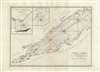
Although critical to trade and pilgrimage, a combination of shallow reefs, an unwelcoming coastline, and unpredictable wind patterns restricted hydrographic mapping and made Red Sea navigation daunting. Knowledge of safe routes through the reefs and shoals were jealously guarded by the Arab coastal traders who dominated the Jeddah Route. Consequently, the Red Sea was poorly understood and dangerous to other travelers well into the 19th century, until the rise of steam navigation mitigated some of these issues. The general vagary here is illustrative of the overall lack of maritime reconnaissance. Soundings are few and far between, being limited to the Sea of Suez. The cities of Aqaba (Acaba), Jordan, and Eilat (Ailah), Israel, are noted, as is the site of Mt. Sinai. The remainder is nautically vague, with reefs ghosted in, especially along the Arabian coast. Safe anchorages are noted here and there. Inset maps in the upper left quadrant detail the Harbor of Suez and the Harbor of Tor.From Mocha to Jeddah
When this map set was issued, the most active maritime trade route in the Red Sea connected Mocha (Moka) and Jeddah (Geddah). Jeddah, further north, was and is the maritime gateway for the Islamic Hajj to Mecca. Mocha, today part of Yemen, was the world's largest exporter of coffee and is the source of the modern term 'mocha.' Insets illustrate Shake Omar, Gedan, Goofs, Suakem (Suakin, Sudan), Matuza (Massawa, Eretria), and Arkiko (Arqiqo, Eretria). It was assumed, post-publication, based upon French reports, that this map's situation of the coffee center Moka (Mocha) was off by some 15 minutes. Subsequent explorations by the Danish navigator Niebuhr confirmed that the location of Mocha as presented here is correct to within a minute.Dodwell
A series of curious annotations in the upper right quadrant offer insight into the history of this chart. It was originally prepared from a manuscript drawn by one 'Mr. Dodwell', who could only be Henry Dodwell, the famed 17th-century Egyptologist. That the cartographic sources referenced were nearly 100 years old when this map was made underscores the lack of fresh knowledge plaguing Red Sea hydrography.Publication History and Census
This chart is cartographically derived from Jean-Baptiste d'Apres de Mannevillette's similar chart issued for the 1745 Neptune Oriental. It was twice reissued by Sayer and Bennet, and again, in this updated version by Laurie and Whittle, who acquired the Sayer and Bennet printing plates. The present Laurie and Whittle example is notable for several important updates based upon survey work conducted by Danish navigator Mr. C. Niebuhr in 1762-3.Cartographer
Laurie and Whittle (fl. 1794 - 1858) were London, England, based map and atlas publishers active in the late 18th and early 19th century. Generally considered to be the successors to the Robert Sayer firm, Laurie and Whittle was founded by Robert Laurie (c. 1755 - 1836) and James Whittle (1757-1818). Robert Laurie was a skilled mezzotint engraver and is known to have worked with Robert Sayer on numerous projects. James Whittle was a well-known London socialite and print seller whose Fleet Street shop was a popular haunt for intellectual luminaries. The partnership began taking over the general management of Sayer's firm around 1787; however, they did not alter the Sayer imprint until after Sayer's death in 1794. Apparently Laurie did most of the work in managing the firm and hence his name appeared first in the "Laurie and Whittle" imprint. Together Laurie and Whittle published numerous maps and atlases, often bringing in other important cartographers of the day, including Kitchin, Faden, Jefferys and others to update and modify their existing Sayer plates. Robert Laurie retired in 1812, leaving the day to day management of the firm to his son, Richard Holmes Laurie (1777 - 1858). Under R. H. Laurie and James Whittle, the firm renamed itself "Whittle and Laurie". Whittle himself died six years later in 1818, and thereafter the firm continued under the imprint of "R. H. Laurie". After R. H. Laurie's death the publishing house and its printing stock came under control of Alexander George Findlay, who had long been associated with Laurie and Whittle. Since, Laurie and Whittle has passed through numerous permeations, with part of the firm still extant as an English publisher of maritime or nautical charts, 'Imray, Laurie, Norie and Wilson Ltd.' The firm remains the oldest surviving chart publisher in Europe. More by this mapmaker...
Condition
Very good. Centerfold mend to both sheets. Size noted is for individual sheets.
References
OCLC 502991021, 837645156.