This item has been sold, but you can get on the Waitlist to be notified if another example becomes available, or purchase a digital scan.
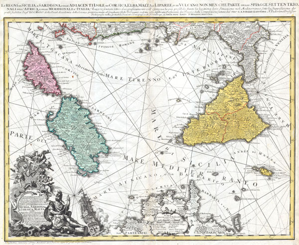
1762 Homann Heirs Map of Sicily, Sardenia, Corsica and Malta (ITALY)
RegniSicilia-homannheirs-1762$475.00

Title
Li Regni di Sicilia e Sardegna colle Adiacenti Isole di Corsica, Elba, Malta e Liparee, o di Vulcano, non men che parte delle spiagge settentrionali dell'Africa e delle Meridionali d'Italia, Rappresentate Idro- Geograficamente e all'esattezza la più possibile, stante la legittima loro Situazione nel Mediterraneo sotto la Supposizione dei grandi stabiliti dagl'Eccmiss.mi della Reial Accademia delle Scienze, proporzionata al Graduato Globo Terraqueo: ridotta alla desiderata Perfezione dai Viaggi e dalla composizione fattane dal Sig. e G.A.B. Rizzi Zannoni N. Padovano Professore di Geografia nella spettabile Società Cosmografica di Norimbergo, A spese degl'Eredi d'Homann MDCCLXII.
1762 (dated) 19 x 22.5 in (48.26 x 57.15 cm)
1762 (dated) 19 x 22.5 in (48.26 x 57.15 cm)
Description
This is one of the Homann Heirs finest and most appealing maps of southern Italy, Sicily and Sardinia. Covers the region from Corsica and the boot of Italy south to Tunisia and North Africa. Includes the island of Malta in the lower right quadrant. Lower left quadrant offers an elaborate title cartouche with a sailing ship, armorial shields of Sicily, Sardinia and Malta, and a warrior, possibly Persus, bearing Medusa shield. Geographically speaking, the map is generally accurate though the coastlines do indicate some improvements and updates over previous Homann maps. Rougly translated the lengthy title reads: The Kingdoms of Sicily and Sardinia with Adjacent Island of Corsica, Elba, Malta and Liparee or Vulcano, and the beaches of Northern Africa and Southern Italy. Represented as geographically accurate as possible, bearing on their legitimate situation in the Mediterranean under the supposition of established geography of the Reial Acadmey of Sciences, proportional to the graduated globe of the Earth; reduced to the desired size and composition by Mr. G. A. B. Rizzi Zannoni, Professor of Geography of the Cosmographic Company of Nuremburg, for the Heirs of Homann MDCCLXII. This map was drawn by G. A. b. Rizzi Zannoni N. Padovano for inclusion the 1752 Homann Heirs Maior Atlas Scholasticus ex Triginta Sex Generalibus et Specialibus…. Most early Homann atlases were 'made to order' or compiled of individual maps at the request of the buyer. However, this rare atlas, composed of 37 maps and charts, was issued as a 'suggested collection' of essential Homann Heirs maps. A fine copy of an important map.
Cartographer
Homann Heirs (1730 - 1848) were a map publishing house based in Nuremberg, Germany, in the middle to late 18th century. After the great mapmaker Johann Baptist Homann's (1664 - 1724) death, management of the firm passed to his son Johann Christoph Homann (1703 - 1730). J. C. Homann, perhaps realizing that he would not long survive his father, stipulated in his will that the company would be inherited by his two head managers, Johann Georg Ebersberger (1695 - 1760) and Johann Michael Franz (1700 - 1761), and that it would publish only under the name 'Homann Heirs'. This designation, in various forms (Homannsche Heirs, Heritiers de Homann, Lat Homannianos Herod, Homannschen Erben, etc..) appears on maps from about 1731 onwards. The firm continued to publish maps in ever diminishing quantities until the death of its last owner, Christoph Franz Fembo (1781 - 1848). More by this mapmaker...
Condition
Very Good condition. Very minor centerfold discoloration. Blank on verso.
References
Phillips, Lee Philip, A List of Geographical Atlases in the Library of Congress, page 44.