This item has been sold, but you can get on the Waitlist to be notified if another example becomes available, or purchase a digital scan.
1762 Homann Heirs/ Rizzi-Zannoni Map of Corsica, Sardinia and Sicily
regnisicilia-homannheirs-1762-2$325.00

Title
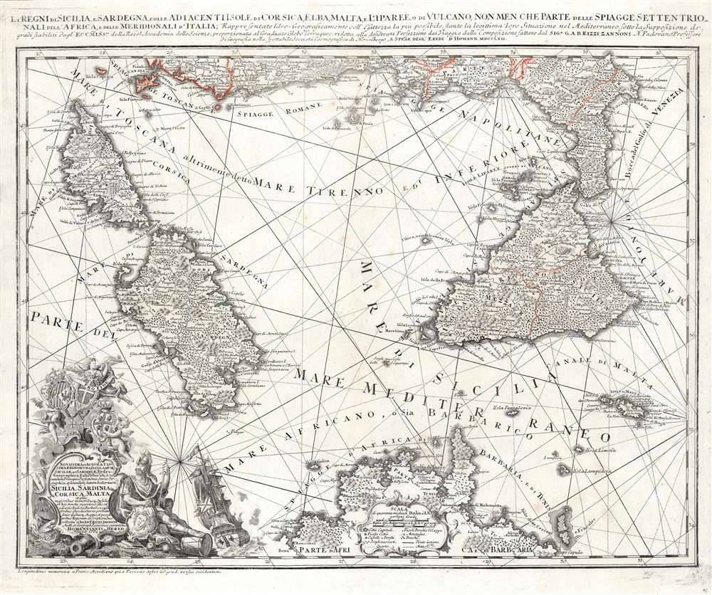
Li Regni di Sicilia e Sardegna colle Adiacenti Isole di Corsica, Elba, Malta e Liparee, o di Vulcano, non men che parte delle spiagge settentrionali dell'Africa e delle Meridionali d'Italia, Rappresentate Idro- Geograficamente e all'esattezza la più possibile, stante la legittima loro Situazione nel Mediterraneo sotto la Supposizione dei grandi stabiliti dagl'Eccmiss.mi della Reial Accademia delle Scienze, proporzionata al Graduato Globo Terraqueo: ridotta alla desiderata Perfezione dai Viaggi e dalla composizione fattane dal Sig. e G.A.B. Rizzi Zannoni N. Padovano Professore di Geografia nella spettabile Società Cosmografica di Norimbergo, A spese degl' Eredi d'Homann MDCCLXII.
1762 (dated) 18.5 x 22.5 in (46.99 x 57.15 cm) 1 : 1750000
1762 (dated) 18.5 x 22.5 in (46.99 x 57.15 cm) 1 : 1750000
Description
This superbly detailed map, engraved by Homann Heirs in 1762 based on the work of Giovanni Antonio Bartolomeo Rizzi-Zannoni, is among the finest and most appealing maps of Corsica, Sicily and Sardinia. The map encompasses the Mediterranean from Corsica to Malta and the Gulf of Venice, and from the west coast of Italy to the Tunisian coast of Africa. The map's complex stereographic projection allows the presentation of the three main islands of the map to be presented as if on a plane, while necessarily distorting the areas at the edge of the map; it is also generally oriented to the northeast, resulting in the unusual and symmetrical presentation of the region. The map is significantly more complex and detailed than previous Homann or Homann Heirs maps; this is due to the work of the Italian cartographer Rizzi-Zannoni, who in 1757 had traveled to Germany to enter the service of Prussia during the Seven Years' War.
A Beautiful, Allegorical Cartouche
The elaborate cartouche in the lower left quadrant, accompanied by a fine sailing ship, displays the armorial shields of Sicily, Sardinia and Malta. A warrior reclines beside the cartouche, probably Mars but possibly Perseus: he bears a shield decorated with Medusa's head. Perseus slew the Gorgon Medusa using Athena's mirrored shield to avoid being stoned (as everybody must be) but Medusa's head is displayed as an aegis on Athena's shield often in classical art, so presumably the shield is hers. The bearded warrior is in no way Athena, so perhaps her shield is here on loan again.Publication History and Census
The map was engraved in 1762, and would be included in Homann Heirs atlases (both composite atlases and the Maior Atlas Scholasticus ex Triginta Sex Generalibus et Specialibus, a rare atlas, composed of 37 maps and charts, issued as a 'suggested collection' of essential Homann Heirs maps. We see perhaps 20 examples of the separate map in institutional collections.CartographerS
Giovanni Antonio Bartolomeo Rizzi Zannoni (September 2, 1736 - May 20, 1814) was an 18th century Italian cartographer active in Venice and Naples. Zannoni was born in Padua, Italy on September 2, 1736. Between 1749 and 1751 Zannoni studied Astronomy at the University of Padua under John Polen, a prominent astronomer of the period. After leaving the University, Zannoni was commissioned by the King of Poland, Augustus III, to map that country. Zannoni's subsequent survey is considered the first accurate triangulation of Poland. Afterwards Zannoni's services were in high demand and he traveled around much of Europe, working on various surveys in Denmark, Germany, Prussia, and Sweden. Around 1757 Zannoni was caught up in the hostilities surrounding the Seven Year War and, after one battle, was taken to Paris as a prisoner of war. Paris must have suited Zannoni for he remained for nearly 20 years, even taking service with the Paris Engineer's Office. It was also here in Paris the Zannoni developed the cartographic contacts that would lead to his most prolific cartographic publications, including the Atlas Moderne in conjunction with Lattre. In 1781, Zannoni was called to Naples by the Bourbon monarchy to help in the revision of the Charter of 1769. Afterwards he stayed on and produced a numerous important maps of the Kingdom of Naples. Zannoni is considered a careful and precise cartographer and his work, particularly the maps he made in Naples, have been praised by R.V. Tooley as 'remarkable for a marvelously minute attention to detail, and amply deserves the commendation passed upon it by Sir George Fordham' (Tooley, Maps and Mapmakers, 21). Zannoni would spend the remainder of his days in Naples and passed away on May 20, 1814. More by this mapmaker...
Homann Heirs (1730 - 1848) were a map publishing house based in Nuremberg, Germany, in the middle to late 18th century. After the great mapmaker Johann Baptist Homann's (1664 - 1724) death, management of the firm passed to his son Johann Christoph Homann (1703 - 1730). J. C. Homann, perhaps realizing that he would not long survive his father, stipulated in his will that the company would be inherited by his two head managers, Johann Georg Ebersberger (1695 - 1760) and Johann Michael Franz (1700 - 1761), and that it would publish only under the name 'Homann Heirs'. This designation, in various forms (Homannsche Heirs, Heritiers de Homann, Lat Homannianos Herod, Homannschen Erben, etc..) appears on maps from about 1731 onwards. The firm continued to publish maps in ever diminishing quantities until the death of its last owner, Christoph Franz Fembo (1781 - 1848). Learn More...
Source
Homann Heirs Maior Atlas Scholasticus ex Triginta Sex Generalibus et Specialibus… Nuremberg, c. 1762.
Condition
Very good. Complete margins. No text on verso. Original outline color.
References
Rumsey 9753.037. OCLC 159806261. Phillips, L. P., A List of Geographical Atlases in the Library of Congress, p. 44.