This item has been sold, but you can get on the Waitlist to be notified if another example becomes available, or purchase a digital scan.
1749 Vaugondy Map of the Republic of Venice
RepubliqueVenise-vaugondy-1749$100.00

Title
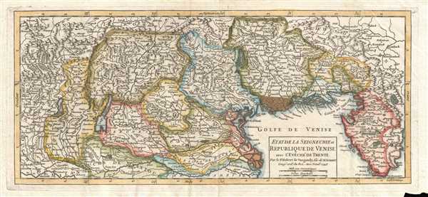
Etat de la Seigneurie et Republique de Venise avec l'Evêché de Trente. Par le Sr. Robert de Vaugondy, fils de M. Robert Geog. ord. du Roi.
1749 (dated) 6.5 x 15 in (16.51 x 38.1 cm) 1 : 1150000
1749 (dated) 6.5 x 15 in (16.51 x 38.1 cm) 1 : 1150000
Description
This is a hand colored 1749 Didier Robert de Vaugondy map of the Republic of Venice in Italy. The map depicts the Republic of Venice following the War of Austrian Succession and stretches from the border with the Duchy of Milan to Istria on the Adriatic and from the border between Venetian land and Tyrol and the Gulf of Venice.
The Republic of Venice prospered and became a thalassocracy, or sea-going empire. Venice's rise began due to the salt trade. They became an economic and trading power during the Middle Ages and the Renaissance. At its height, Venice was renowned for its powerful navy and its endless merchant fleet. The Venetian navy was employed during several of the Crusades, including the infamous Fourth Crusade.
Myriad cities and towns are labeled, including Venice (Venetia), Verona, Padua, and Trieste. Innumerable rivers are depicted throughout the map, as well as mountain ranges and forests in profile.
This map was published by Gilles Robert de Vaugondy in his Atlas Universel, Portatif et Militaire in the 1749 edition.
CartographerS
Robert de Vaugondy (fl. c. 1716 - 1786) was French may publishing from run by brothers Gilles (1688 - 1766) and Didier (c. 1723 - 1786) Robert de Vaugondy. They were map publishers, engravers, and cartographers active in Paris during the mid-18th century. The father and son team were the inheritors to the important Nicolas Sanson (1600 - 1667) cartographic firm whose stock supplied much of their initial material. Graduating from Sanson's maps, Gilles, and more particularly Didier, began to produce their own substantial corpus. The Vaugondys were well-respected for the detail and accuracy of their maps, for which they capitalized on the resources of 18th-century Paris to compile the most accurate and fantasy-free maps possible. The Vaugondys compiled each map based on their own geographic knowledge, scholarly research, journals of contemporary explorers and missionaries, and direct astronomical observation. Moreover, unlike many cartographers of this period, they took pains to reference their sources. Nevertheless, even in 18th-century Paris, geographical knowledge was limited - especially regarding those unexplored portions of the world, including the poles, the Pacific Northwest of America, and the interiors of Africa, Australia, and South America. In these areas, the Vaugondys, like their rivals De L'Isle and Buache, must be considered speculative or positivist geographers. Speculative geography was a genre of mapmaking that evolved in Europe, particularly Paris, in the middle to late 18th century. Cartographers in this genre would fill in unknown lands with theories based on their knowledge of cartography, personal geographical theories, and often dubious primary source material gathered by explorers. This approach, which attempted to use the known to validate the unknown, naturally engendered rivalries. Vaugondy's feuds with other cartographers, most specifically Phillipe Buache, resulted in numerous conflicting papers presented before the Academie des Sciences, of which both were members. The era of speculative cartography effectively ended with the late 18th-century explorations of Captain Cook, Jean Francois de Galaup de La Perouse, and George Vancouver. After Didier died, his maps were acquired by Jean-Baptiste Fortin, who in 1787 sold them to Charles-François Delamarche (1740 - 1817). While Delamarche prospered from the Vaugondy maps, he defrauded Vaugondy's window Marie Louise Rosalie Dangy of her rightful inheritance and may even have killed her. More by this mapmaker...
Guillaume-Nicolas Delahaye (1725 - February 24, 1802) was the most prolific member of the Delahaye (De-La-Haye) family of engravers active in Paris throughout the 18th century. Given that the name, Delahaye literally translates to 'of the Hague' it can be assume they were French Huguenots who were forced to flee the Netherlands under threat of religious persecution. Born in Paris, he was the son of patriarch Jean-Baptiste Delahaye and brother to Jean-Baptistie-Henri Delahaye. It is said that his godfather, who held him at the baptismal font, was none other than the famous french cartographer Guillaume de L'Isle. The Delahaye family engraved for many of the great cartographers of 18th century Paris, including Jean-Baptiste Bourguignon d'Anville, Didier Robert de Vaugondy, Jean-Baptiste de Mannevillette, and Jean-Nicolas Buache, among others. He was awarded the public office Premier Graveur du Roi and worked on a series of maps illustrating the king's hunts around Versailles. Guillaume also worked with foreign cartographers such as Tomas Lopez of Madrid. Possibly Delahaye's most significant map is A Map of the Country between Albemarle Sound and Lake Erie prepared for the memories of Thomas Jefferson. He married in 1758. In total he engraved some 1200 maps. Delahaye died in Charenton. In 1792, his daughter, Antoinette Marie Delahaye (1773-1857), married the geographer Jean-Denis Barbie du Bocage. Learn More...
Source
Robert de Vaugondy, G., Atlas Portatif, Universel, et Militaire, (Paris: Vaugondy, Durand, Pissot) 1749.
Condition
Very good. Blank on verso. Original press mark visible. Slight loss to lower margin.
References
Pedley, M. S., Bel et Utile, p. 190, 346. OCLC 780757221.