This item has been sold, but you can get on the Waitlist to be notified if another example becomes available, or purchase a digital scan.
1730 Homann Map of the Upper Rhine ( Frankfurt, Cassel, Coblentz, Darmstadt )
RhenanusSuperior-homann-1730$150.00

Title
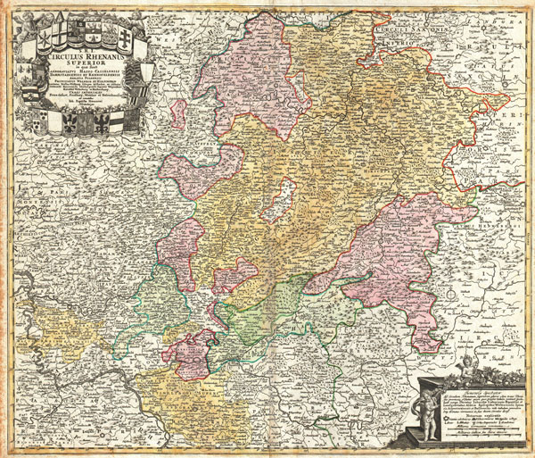
S.R.I. Circulus Rhenanus Superior in quo sunt Landgraviatus Hasson Casselensis, Darmstadiensis et Rhenofeldensis Abbatia Fuldensis…
c. 1730 (undated) 19.25 x 22.75 in (48.895 x 57.785 cm)
c. 1730 (undated) 19.25 x 22.75 in (48.895 x 57.785 cm)
Description
A beautifully detailed c. 1730 Homann Heirs map of Upper Rhine region. Covers from Coblentz eastward as far as Schweinfurt, Schmalkalden and Mulhausen; northwards as far as Gottingen; and southwards as far as Darmstadt and Wertheim. Includes the cities of Cassel, Hirschfeld, Fulda, Frankfurt am Oder, Darmstadt, Nassaw, and Marpurb. The map details fortified cities, villages, roads, bridges, forests, castles and topography. The title cartouche in the upper left quadrant features twenty-one heraldic crests, each representing a major city. Curiously, four are blank. Legend with cherubs in lower right quadrant. This map was drawn in Nuremberg by J. B. Homann and issued in Homann's Grosser Atlas as well as in the Homann Heirs' Maior Atlas Scholasticus ex Triginta Sex Generalibus et Specialibus…. .
Cartographer
Johann Baptist Homann (March 20, 1664 - July 1, 1724) was the most prominent and prolific map publisher of the 18th century. Homann was born in Oberkammlach, a small town near Kammlach, Bavaria, Germany. As a young man, Homann studied in a Jesuit school and nursed ambitions of becoming a Dominican priest. Nonetheless, he converted to Protestantism in 1687, when he was 23. It is not clear where he mastered engraving, but we believe it may have been in Amsterdam. Homann's earliest work we have identified is about 1689, and already exhibits a high degree of mastery. Around 1691, Homann moved to Nuremberg and registered as a notary. By this time, he was already making maps, and very good ones at that. He produced a map of the environs of Nürnberg in 1691/92, which suggests he was already a master engraver. Around 1693, Homann briefly relocated to Vienna, where he lived and studied printing and copper plate engraving until 1695. Until 1702, he worked in Nuremberg in the map trade under Jacob von Sandrart (1630 - 1708) and then David Funck (1642 - 1709). Afterward, he returned to Nuremberg, where, in 1702, he founded the commercial publishing firm that would bear his name. In the next five years, Homann produced hundreds of maps and developed a distinctive style characterized by heavy, detailed engraving, elaborate allegorical cartouche work, and vivid hand color. Due to the lower cost of printing in Germany, the Homann firm could undercut the dominant French and Dutch publishing houses while matching their diversity and quality. Despite copious output, Homann did not release his first major atlas until the 33-map Neuer Atlas of 1707, followed by a 60-map edition of 1710. By 1715, Homann's rising star caught the attention of the Holy Roman Emperor Charles VI, who appointed him Imperial Cartographer. In the same year, he was also appointed a member of the Royal Academy of Sciences in Berlin. Homann's prestigious title came with several significant advantages, including access to the most up-to-date cartographic information as well as the 'Privilege'. The Privilege was a type of early copyright offered to very few by the Holy Roman Emperor. Though less sophisticated than modern copyright legislation, the Privilege offered limited protection for several years. Most all J. B. Homann maps printed between 1715 and 1730 bear the inscription 'Cum Priviligio' or some variation. Following Homann's death in 1724, the firm's map plates and management passed to his son, Johann Christoph Homann (1703 - 1730). J. C. Homann, perhaps realizing that he would not long survive his father, stipulated in his will that the company would be inherited by his two head managers, Johann Georg Ebersberger (1695 - 1760) and Johann Michael Franz (1700 - 1761), and that it would publish only under the name 'Homann Heirs'. This designation, in various forms (Homannsche Heirs, Heritiers de Homann, Lat Homannianos Herod, Homannschen Erben, etc.) appears on maps from about 1731 onwards. The firm continued to publish maps in ever-diminishing quantities until the death of its last owner, Christoph Franz Fembo (1781 - 1848). More by this mapmaker...
Source
Major Atlas Scholasticus Ex Triginta sex Generalibus et Specialibus Mappis Homannianis..., c. 1750. / Also issued in Homann's Grosser Atlas
Condition
Very good condition. Original centerfold exhibits minor discoloration. Foxing to outer margins. Original platemark visible. Blank on verso.
References
Stanford University, Map Collection, Germany 0295. Phillips (Atlases), 4195.13