This item has been sold, but you can get on the Waitlist to be notified if another example becomes available, or purchase a digital scan.
1855 Walling Wall Map of Rhode Island
RhodeIsland-walling-1855-2$1,750.00

Title
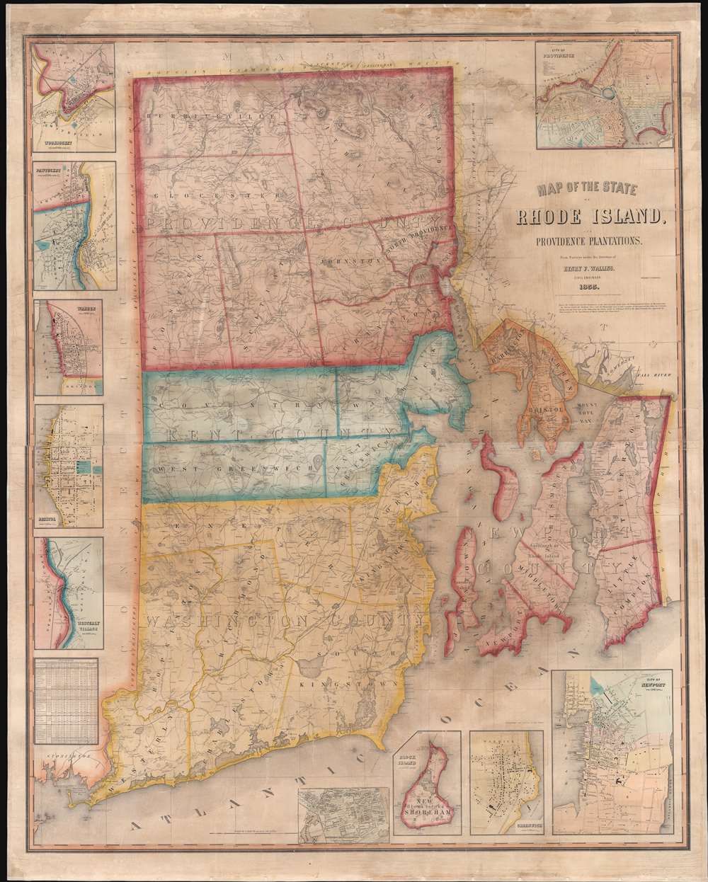
Map of the State of Rhode Island and Providence Plantations.
1855 (dated) 57 x 46 in (144.78 x 116.84 cm) 1 : 63360
1855 (dated) 57 x 46 in (144.78 x 116.84 cm) 1 : 63360
Description
A scarce 1855 wall map of Rhode Island by the civil engineer Henry F. Walling. Centered on Narragansett Bay, the map covers the state and offers eleven detailed insets of various cities. Walling identifies countless individual estates and homesteads throughout - making this a treasure for anyone researching family history or mid-19th Rhode Island land holdings. Roads, counties, topography, railroads, lakes, and rivers are noted. Narragansett Bay features numerous depth soundings, no doubt drawn from the work of the U.S. Coast Survey. The insets, from top left detail Woonsocket, Pawtucket, Warren, Bristol, Westerly Village, Smithville (Scituate), Wickford, Block Island, Greenwich, Newport, and of course Providence. In the Providence inset the campus of Brown University is identified.
Publication History and Census
The present example is the first, 1855, edition of this map. It was engraved in Boston by Lodowick Harrington Bradford and published by Henry F. Walling. It was subsequently reissued in the 1860s on an even larger scale. In his long career as a cartographer Walling produced only three state maps: Rhode Island, Vermont, and Maine. All examples are extremely scarce and rare to the market.CartographerS
Henry Francis Walling (June 11, 1825 - April 8, 1889) was an American civil engineer, cartographer, surveyor, and map publisher active from the middle to late 19th century. Walling was born in Providence, Rhode Island. He studied/worked at the Providence Athenaeum before discovering a talent for mathematics and surveying. Walling took a position with Samuel Barrett Cushing (1846 - 1888), a Providence-based civil engineer with whom he issued in 1846 a revision of James Steven's Topographical Map of the State of Rhode-Island. Walling established himself independently around 1850 and immediately began preparing a series of town plans focusing on Bristol County, near Providence. Buoyed by widespread interest in his plans, Walling expanded his operations to Massachusetts, where, by 1857, he had produced no less than 50 town plans. Apparently, Walling's business model involved a contract with town officials to produce a certain number of maps, after which he acquired the right to print and sell additional copies on his own account. This work eventually led to Walling's appointment as Massachusetts "Superintendent of the State Map", a designation that began appearing on his maps around 1855. While Walling's work focused heavily on city and county maps, he successfully published three scarce state maps: Maine, Vermont, and Rhode Island. In 1856, Walling relocated his headquarters to New York City, where he had better access to quality lithographers. The Civil War (1861 - 1865) proved difficult for Walling, and diminished sales may have forced him into a partnership with Ormando W. Gray, with whom he published numerous state, county, and national atlases in the 1860s and 1870s. Around 1880, Walling took a post with the U.S. Coast Survey, with whom he worked on various charts until requesting a transfer in 1883 to the newly formed U.S. Geological Survey. Walling remained with the Geological Survey until his untimely death of a heart attack in April 1889. More by this mapmaker...
Lodowick Harrington Bradford (November 10, 1820 - December 13, 1885) was a Boston based engraver lithographer active in the second half of the 19th century. Bradford was born in Boston, Massachusetts. He studied as a line engraver before transitioning to the then new art of lithography. He even invented his own photolithographic ambrotype process that created a durable photographic picture on lithographic stone. In 1849 he partnered with Ebenezer Tappen (1815 - 1854) to form the Boston firm of Tappan and Bradford. The partnership remained active until Tappan's untimely death in January, 1854. From 1854 to 1859 Bradford continued to operate the firm, but the imprint changed to 'L. H. Bradford and Company.' It is not clear who the 'and Company' was, possibly Tappan's heirs? From late 1859 until his 1870, he printed under 'L. H. Bradford.' His last known lithographs appeared in 1860, but he did continue copper and steel engraving until his death. Bradford was married to Martha Brown, from an old Gloucester Family. After his wedding in 1849, he divided his time between Gloucester and Boston. In Gloucester he made the acquaintance of the local painter Fitz Henry Lane (1804 - 1865) and worked with him to produce several views in the 1850s. He died on the road between Boston and Gloucester in 1885. Learn More...
Condition
Very good. Professionally restored and re-laid on fresh linen.
References
Chapin, H. M., Check List of Maps of Rhode Island, no. 77. OCLC 865615624. Harvard, Hollis: 990095578080203941. Boston Public Library, Leventhal, #G3770 1855 .W35.