1866 Dépôt de la Marine Nautical Map of Guanabara Bay, Rio de Janeiro, Brazil
RioDeJaneiroBay-depotmarine-1866$1,000.00

Title
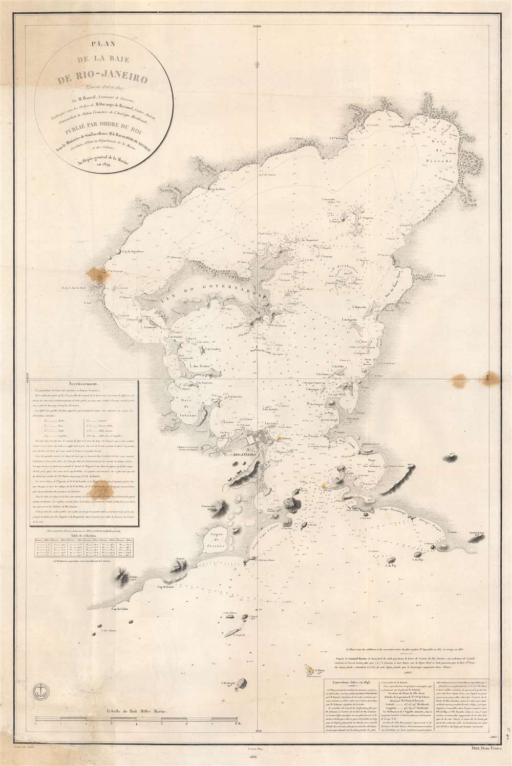
Plan de la Baie de Rio - Janeiro.
1866 (dated) 35.5 x 24 in (90.17 x 60.96 cm) 1 : 61400
1866 (dated) 35.5 x 24 in (90.17 x 60.96 cm) 1 : 61400
Description
This is an 1866 edition of the Dépôt de la Marine nautical chart or map of Guanabara Bay, Rio de Janeiro, Brazil. Rio de Janeiro appears near the mouth of the bay, with numerous buildings illustrated but not labeled. The only identified building is the Chateau S. Cristovaô (situated outside the city) which is marked as the Residence of the Emperor. The Ile do Governador (Ilha do Governador - today the site of Rio de Janeiro's Galeão - Antônio Carlos Jobim International Airport) is prominently illustrated, with its coastline appearing in detail. Numerous smaller islands throughout the bay are depicted as well. Smaller bays, capes, points, and even beaches are labeled around the bay. Depth soundings fill the bay, providing a more detailed understanding of its navigability.
Publication History and Census
This map was drawn by Jacques-Marie Hacq, engraved by Jean-François Caplin, and first published by the Dépôt de la Marine in 1829. Numerous subsequent editions were published with varying updates throughout the rest of the 19th century and into the beginning of the 20th century. The present example represents the 1866 edition, of which this is the only known cataloged example. We have found only a handful of instances when other editions of this chart have appeared on the private market.CartographerS
Dépôt des Cartes et Plans de la Marine (fl. 1720 - present), often called the Dépôt de Marine, was a French hydrographic mapping organization founded in 1720 under Charles-Hercule of Albert de Luynes (1674 - 1734). Much like the U.S. Coast Survey, the British Admiralty, and the Spanish Deposito Hydrografico, the Dépôt was initiated as a storehouse and distribution center of existing nautical and marine charts. Eventually the Dépôt initiated its own mapping activities in an attempt to improve and expand upon existing material. Some of the more prominent cartographers and hydrographers associated with the of Dépôt des Cartes were, Philippe Buache, Jacques-Nicholas Bellin, Giovanni Rizzi-Zannoni, Rigobert Bonne, and Jean Nicolas Buache. More by this mapmaker...
Jacques-Marie Hacq (September 22, 1785 – 18??) was a French letter and line engraver, and historian, active in Paris during the middle part of the 19th century. Hacq was born in Paris and trained under J. P. Besançon, who he succeeded at the Dépôt de la Guerre in 1830. He engraved for the Dépôt de la Guerre as early as 1830 and for the Dépôt des Cartes et Plans de la Marine from, at least, 1840 to 1852. In addition to his work for the French Government, he also completed maps and engravings for Lesage, Lapie, Dufour, Duperrez, Gouvion St. Cyr, and Dumont d'Urville. His historical works include a history of the Napoleonic Wars and a history of Paris under the reign of Louis XIII. During most of his career in Paris he lived at 58 Rue de la Harpe. Learn More...
Jean-François Caplin (1779 - c. 1829) was a French engraver. He worked for the Dépôt de la Marine and the Administration des Ponts et Chuassées and created topographic maps and nautical charts. Learn More...
Condition
Good. Soiling. Closed margin tears professionally repaired on verso.