This item has been sold, but you can get on the Waitlist to be notified if another example becomes available, or purchase a digital scan.
1809 Azara Maps of Argentina, Chile, Bolivia, Paragua, Uruguay and Brazil
RiodelaPlata-azara-1809$875.00

Title
(Untitled Maps of the Viceroyalty of the Río de la Plata)
1809 (undated) 17 x 23.5 in (43.18 x 59.69 cm) 1 : 2100000
1809 (undated) 17 x 23.5 in (43.18 x 59.69 cm) 1 : 2100000
Description
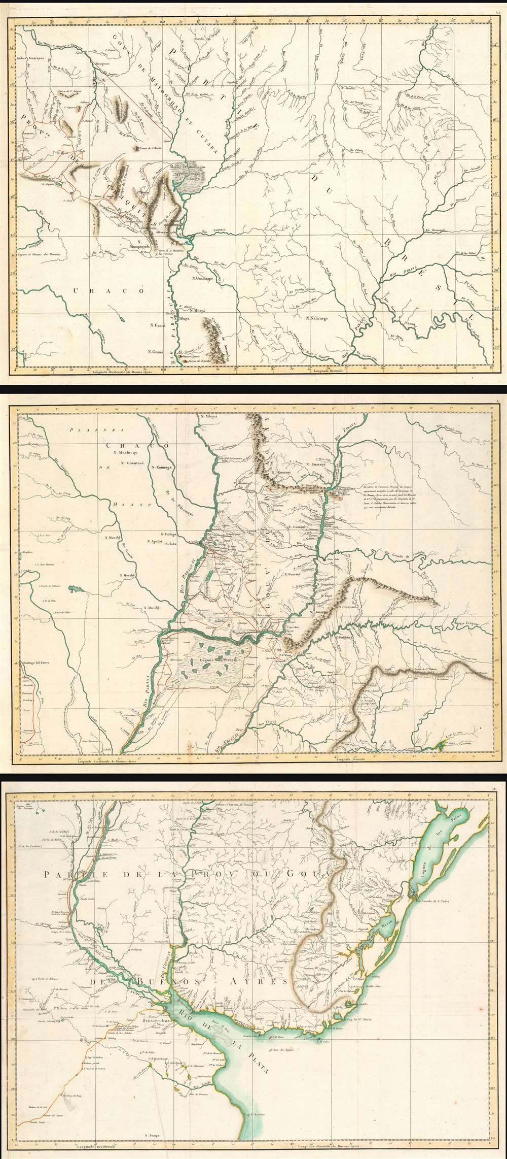
This is a set of three 1809 maps of the Rio de la Plata region of South America, produced by the Spanish border commissioner and military engineer Félix de Azara. The map shows the results of Azara's surveys, made over the course of twenty years, in order to fix the borders between the Spanish and the Portuguese colonies there pursuant to the First Treaty of San Ildefonso. Beyond simply establishing the border of Brazil, the surveys were intended to realize the establishment of The Viceroyalty of the Río de la Plata (Virreinato del Río de la Plata), the last organized and the shortest-lived of the Viceroyalties of the Spanish Empire in the Americas.
The Viceroyalty was first established in 1776, and comprised parts of modern day Argentina, Chile, Bolivia, Paraguay and Uruguay. Its borders contained the watersheds of the Parana, Uruguay, and Paraguay Rivers from the Rio de la Plata up to Bolivia and Brazil. Buenos Aires was to be the capital, chosen because of its position opposite the Río de la Plata estuary from the Portuguese outpost of Colonia del Sacramento. Very little of these lands had been well surveyed prior to the treaty, and for Azara's team to be successful in fixing the borders such surveys had to be undertaken. In many cases, the treaty indicated that the border should fall on rivers which in fact did not exist.
The three untitled maps are as follows:
Portugal would cede to Spain the Colonia del Sacramento and the island of San Gabriel (found on sheet IV) as well as the Misiones Orientales(detailed on sheet V) and Spain acknowledged Portuguese control of Southern Brazil (see sheet VI) and returned Santa Catarina island to Portugal. Delegations to establish these borders in fine were to be sent to the area both by Spain and Portugal; as it happened only the Spanish delegation would appear. The delegate and military engineer Félix de Azara would remain in the region for twenty years, and in addition to his extensive and well regarded natural history of of the Rio de la Plata region would produce these superbly detailed maps of the contested area.
The Viceroyalty was first established in 1776, and comprised parts of modern day Argentina, Chile, Bolivia, Paraguay and Uruguay. Its borders contained the watersheds of the Parana, Uruguay, and Paraguay Rivers from the Rio de la Plata up to Bolivia and Brazil. Buenos Aires was to be the capital, chosen because of its position opposite the Río de la Plata estuary from the Portuguese outpost of Colonia del Sacramento. Very little of these lands had been well surveyed prior to the treaty, and for Azara's team to be successful in fixing the borders such surveys had to be undertaken. In many cases, the treaty indicated that the border should fall on rivers which in fact did not exist.
The three untitled maps are as follows:
Sheet IV
This is the southernmost of the three maps. Roughly centered on Buenos Aires, it extends from Cabo San Antonio in Buenos Aires province up to include Lagoa dos Patos; thus it embraces the mouth of the Rio de la Plata, the whole of Uruguay, and northeastern Argentina (Santa Fe appears on the Rio Paraná).Sheet V
This sheet, centered on Asunción, embraces the southern half of Paraguay, the western parts of the Brazilian states of Parana and Santa Catarina, and the northern extent of Rio Grande do Sul. Its best detail is for the Misiones Orientales, the network of Jesuit missions along the Rio Paraná, between the Rio Paraguay and the Rio Uruguay.Site of the Itaipú Dam
The Rio Paraná is marked with the great Guaíra Falls; the area along the Paraná from those falls to the mouth of the Rio Acaray is now occupied by the sprawling Lago Itaipú, created by the massive hydroelectric dam of the same name. Today, the Guaíra Falls no longer exist, having been inundated by Lago Itaipú (and the rock face removed as a threat to navigation.)Sheet VI
The northernmost map focuses on the headwaters of the Rio Paraguay and the Rio Paraná; it includes the Chiquitos province of Bolivia and the Cuiabá province of Brazil. Here we see some of the efforts of the survey team to reconcile the treaty demands with the lay of the land. The team called upon to describe a straight line from the mouth of the Río Jaurú to the southern shore of the Río Guaporé, and on the map we see such a line, described between two points marked 'signal:' likely gunpowder fires set at agreed-upon times and observed at distance by the surveyors.Laguna de Xarayes
The mythical Laguna de Xarayes is illustrated here as a wetland representing the source of the Paraguay River. The Xarayes, a corruption of 'Xaraies' meaning 'Masters of the River', were an indigenous people occupying what are today parts of Brazil's Mato Grosso and the Pantanal. When Spanish and Portuguese explorers first navigated up the Paraguay River, as always in search of El Dorado, they encountered the vast Pantanal flood plain at the height of its annual inundation. Understandably misinterpreting the flood plain as a gigantic inland sea, they named it after the local inhabitants, the Xaraies. The Laguna de los Xarayes almost immediately began to appear on early maps of the region and, at the same time, to take on a legendary quality. Later missionaries and chroniclers, particularly Díaz de Guzman, imagined an island in this lake and curiously identified it as an 'Island of Paradise,'...an island [of the Paraguay River] more than ten leagues [56 km] long, two or three [11-16 km] wide. A very mild land rich in a thousand types of wild fruit, among them grapes, pears and olives: the Indians created plantations throughout, and throughout the year sow and reap with no difference in winter or summer, ... the Indians of that island are of good will and are friends to the Spaniards; Orejón they call them, and they have their ears pierced with wheels of wood ... which occupy the entire hole. They live in round houses, not as a village, but each apart though keep up with each other in much peace and friendship. They called of old this island Land of Paradise for its abundance and wonderful qualities.Xarayes was, throughout the 18th century considered a possible gateway to the supposed riches of the Amazon interior.
The First Treaty of San Ildefonso
This 1777 treaty between Spain and Portugal was forged in order to settle long-standing border disputes in South America between the two empires, particularly in the Rio de la Plata region, resulting from different interpretations of the nearly 300-year-old Treaty of Tordesillas. In the year leading up to the treaty the conflict had (again) become violent: In February of 1777, Spain's new Viceroy of Río de la Plata, Pedro Antonio de Cevallos, led an expeditionary force to attack and capture the island of Santa Catarina, followed by the Colonia del Sacramento at the mouth of the Rio de la Plata. Following the death of King Joao I, Portugal called for peace, and a treaty was negotiated.Portugal would cede to Spain the Colonia del Sacramento and the island of San Gabriel (found on sheet IV) as well as the Misiones Orientales(detailed on sheet V) and Spain acknowledged Portuguese control of Southern Brazil (see sheet VI) and returned Santa Catarina island to Portugal. Delegations to establish these borders in fine were to be sent to the area both by Spain and Portugal; as it happened only the Spanish delegation would appear. The delegate and military engineer Félix de Azara would remain in the region for twenty years, and in addition to his extensive and well regarded natural history of of the Rio de la Plata region would produce these superbly detailed maps of the contested area.
Publication History and Census
These maps were printed to accompany Azara's 1809 Voyages dans l'Amerique Meridionale; Perhaps thirty complete examples of the Voyages are catalogued in OCLC, and examples of the Atlas appear as well. Separate examples of the maps appear to be rare: OCLC catalogues only two examples of each of these, appearing in the Clements and the Library of Scotland.Cartographer
Azara, Félix de (May 18, 1742 - October 20, 1821) was a Spanish military officer, naturalist, and engineer. He joined the Army, and received training as an engineer in a Spanish military academy. His thirteen year career in the Army would see him promoted to Brigadier General. He spent twenty years in the Rio de la Plata region of South America as a delegate under the treaty of San Ildefonso, during which period he undertook to create an accurate map of the region. On the surveys, he also recorded the fauna the region, in particular cataloguing nearly four hundred species of bird. On his return to Europe in 1801 he wrote and published in Paris his Voyage dans l'Amerique meridionale depuis 1781 jusqu'en 1801 (1809) which contained his observations on the region's geography, natural features, and indigenous groups. His work was praised for thoroughness and accuracy, and was well regarded by Darwin. He died of pneumonia on October 20, 1821. More by this mapmaker...
Source
Félix, A. de Voyage dans l'Amerique meridionale depuis 1781 jusqu'en 1801 (1809).
Condition
Very good condition. Few marginal mends, margin extended on Sheet IV. Original wash and outline color. Approximate measurements given for each separate plate.
References
OCLC 852833251, 852833254, 852833257. Erbig, Jeffrey A., Forging Frontiers: Félix de Azara and the Making of the Virreinato del Río de la Plata, Thesis, University of North Carolina at Chapel Hill, 2010.