
1888 U.S. Navy Nautical Map of the Rio de la Plata

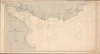
Rio de la Plata and Approaches.
Charting the Rio de la Plata.
- Digital Map Information
- Suitable for large format printing
- Full resolution TIFF file
- ICC color profile embedded
- Delivered instantly via download link
Charting the Rio de la Plata.
This is the June 1888 edition of the United States Hydrographic Office's nautical chart of the Río de la Plata and its Atlantic approaches, bearing the label of New York nautical instrument makers and chart agents D. Eggert's Sons. Covering the passage to Buenos Aires past Montevideo, the chart emphasizes the soundings, banks, and navigational lights essential to negotiating this broad, shallow estuary. Its commercial label links the Navy's chart-production program to the private businesses that supplied navigators with charts, chronometers, and instruments.A Closer Look
The chart extends from the Paraná delta and the entrance to the Uruguay River southeastward across the estuary and its offshore approaches. Buenos Aires occupies the western shore, while Colonia, Montevideo, and Maldonado provide reference points along the Uruguayan coast. Cape San Antonio marks the entrance's southern side. Coastal relief is expressed through hachures, giving particular prominence to the hills behind the Uruguayan shore.Dense soundings describe the navigable water between extensive banks and coastal shallows. Depth contours allow the navigator to follow changes in the submerged landscape, while abbreviations distinguish bottom materials. The Ortiz Bank is explicitly described as imperfectly known, an important qualification in an otherwise well-documented waterway. Such warnings distinguish the apparent precision of the engraved chart from the limits of the information available. Small yellow accents highlight navigational lights along the coasts and within the estuary. Two large compass roses serve the inner and outer approaches. Beneath the title, tables explain abbreviations for bottom characteristics and colors, while another note directs users to separate harbor and special charts for more detailed coverage. The sheet consequently serves as an approach chart rather than a substitute for individual port plans.
A New York Chart Agent
The pasted label at upper left identifies D. Eggert's Sons, chronometer, watch, and nautical instrument makers at 74 Wall Street, New York. It advertises the firm's agency for United States Coast Survey and Hydrographic charts and nautical works. A government chart-sales agency list independently records the firm at this address. The label illustrates the commercial distribution of government hydrography. Established as a separate office in 1866, the Hydrographic Office supplied navigational information for naval and merchant use; its charts reached civilian customers through a network that included private nautical suppliers.Publication History
The chart was drawn by Harrison G. Brewer and engraved by Stephen J. Kübel and John A. Waddey. Its title retains the compilation date 1886, while the lower imprint records publication in October 1886 and the updates of June 1888. It was published in Washington, D.C., by the Hydrographic Office, Navy Department. The chart remained in use in subsequent editions.Cartographers
United States Hydrographic Office (1866 - 1962) was a branch of the U.S. Navy that prepared and published maps, charts, and nautical books to aid in navigation. Before the establishment of the Hydrographic Office in 1866, U.S. navigators were almost entirely dependent on British charts. There had been a few private enterprises that had prepared and published charts, but none had done so profitably. The Office was established 'for the improvement of the means of navigating the vessels of the Navy safely and of the mercantile marine, by providing, under the authority of the Secretary of the Navy, accurate and cheap nautical charts, sailing directions, navigators, and manuals of instructions for the use of all vessels of the United States, and for the benefit and use of navigators generally.' This way the Navy Department could furnish navy and merchant ships with charts illustrating the results of surveys and explorations undertaken by naval officers. The charts were priced to cover the cost of paper and printing alone, not preparation. Its main objective was to survey foreign coasts, as the Coast and Geodetic Surveys were responsible for surveying domestic waters. The Hydrographic Office was transferred from the Department of the Navy to the Department of Defense in 1949 and was replaced by the Naval Oceanographic Office in 1962. Further Details...
Harrison Gaston Brewer (September 21, 1855 - January 22, 1920) was an American hydrographic draftsman based in Washington, D.C., active during the late 19th and early 20th centuries. Born in Annapolis, Maryland, he was a son of Nicholas Brewer (1808 - 1874), formerly adjutant general of Maryland. His documented cartographic career centered on the United States Navy's Hydrographic Office. An early National Geographic Society membership list identifies him by his full name and gives the Hydrographic Office as his professional address; the Navy Department's personnel return for 1891 lists him as a draftsman employed throughout that year. A family biography published in 1915 likewise records his connection with the office. Brewer married Marcie Elliott of Greenville, Tennessee, and they had a son and three daughters. Their daughter Marcy Angela died in Washington on December 24, 1906, aged seventeen; his wife, son, and two other daughters survived him. Brewer died in 1920, and his remains were buried in Washington's Congressional Cemetery on July 14 of that year. Further Details...
Stephen Joseph Kübel (April 2, 1858 - March 2, 1936) was an American musician, cartographer, and map engraver. Born in Washington, D.C., to Edward Kübel and his second wife, Josephine Hartbrecht Kübel, Kübel attended high school in Washington, D.C., before studying at the Scharwenke Conservatory of Music in Berlin. It was during his time in Berlin that Kübel, who was gifted in drawing, developed an interest in cartography and map engraving. He returned to Washington, D.C., in 1875, and found a job with the U.S. Geological and Geographical Survey of the Territories. He joined the staff of the U.S. Navy Hydrographic Office as a cartographer in 1876. From 1883 through 1885, Kübel served in the cartographic division of the Prussian general staff, where he studied alternative map reproduction processes. He rejoined the U.S. Navy Hydrographic Office after returning to Washington, D.C. Kübel opened his own engraving and printing firm in 1887, employing a staff and fulfilling contracts for the U.S. Geological Survey, the Hydrographic Office, and the U.S. Coast and Geodetic Survey. He was named Chief Engraver of the U.S. Geological Survey on February 14, 1890, and tasked with organizing a map-production plant. He was appointed chief of the U.S. Geological Survey's Division of Engraving and Printing in 1911 and became responsible for the production of all the Survey's copper-engraved maps. Kübel remained the Chief Engraver until his retirement in 1932. Kübel married Louise Griffith of Milford, Delaware, on July 5, 1884, while serving in Berlin. Further Details...
John A. Waddey (December 31, 1852 - January 13, 1932) was a map engraver at the U.S. Navy Hydrographic Office. Born in Georgetown, Waddey apprenticed to William M. McDougal, a Georgetown picture engraver. His first job was with French, Langran, and Ogilvie, who did contract work for the U.S. Navy Hydrographic Office and the Treasury Department. He was appointed to the Hydrographic Office as an advanced apprentice engraver in 1872. At that point, the Hydrographic Office contracted out all its map engraving and only updated its charts in-house. The Office had a staff of 12 and only had 24 chart plates. By the time Waddey retired 55 years later, the staff had grown to 154, and the Office had 2,900 charts. Waddey was named Chief Engraver in 1913 and oversaw a staff of 18 engravers. Further Details...
Condition
Very good. Even toning. Pastedown in the upper left corner.
References
Heynen, William J., comp., United States Hydrographic Office Manuscript Charts in the National Archives, 1838 - 1908, Special List 43 (1978), #1390. Related 1891 edition annotated in 1892. Servicio de Oceanografía, Hidrografía y Meteorología de la Armada, Cartografía Náutica Histórica Internacional, registro 11105, número 145.