
1912 Xinxue Huishe City Plan of Hankou (Hankow, Wuhan), China

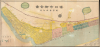
漢口市街全圖 / [Complete Street Map of Hankou].
Hankou in the Early Republican Era.
- Digital Map Information
- Suitable for large format printing
- Full resolution TIFF file
- ICC color profile embedded
- Delivered instantly via download link
Hankou in the Early Republican Era.
This is a rare, large-format c. 1912 city map or plan of Hankou (Hankow), China, now part of Wuhan, printed and published by Xinxue Huishe. It presents the city in the early Republican era, following the revolution (which began in nearby Wuchang) that toppled the Qing Dynasty. This was a transitional period for China in many ways, retaining many legacies of the Qing era, including the numerically small but economically and culturally significant presence of foreigners in foreign concessions at Hankou and other cities, but also looking forward to potential future paths of cultural, economic, and political development.A Closer Look
This map is oriented with northwest at top, allowing for a roughly horizontal presentation of the Yangzi (Yangtse or Yangtze) River and the waterfront of Hankou. Between the Yangzi and its tributary, the Han River (漢江, here as Xiang River 襄河) at the bottom, and the Beijing-Hankou Railway (京漢鐵路) at the top, lies Hankou's developed urban area. At the time, this land was divided between five foreign concessions and a Chinese-administered part of the city. These are color-shaded: yellow for the Chinese city, pink for the British concession, green for the Russian concession, orange for the French concession, blue for the German concession, and purple for the Japanese concession. The map labels streets and alleyways throughout the Chinese city, along with waterways, hills (土墩), and the historic city wall (城垣). Some locations in the foreign concessions are labelled, with coverage very scant in some (the German Concession only notes the consulate 領事署) and more extensive in others, especially the British, recording parks, administrative offices, consulates of countries without their own concessions (like the United States and Switzerland), and churches, including a large complex complete with a hospital built around St. Joseph's Cathedral, also known as the Shanghai Road Catholic Church, on former marshland in the northern part of the concession (land leased by the presumably Protestant British businessmen who ran the concession to Italian Franciscans, characteristic of the cosmopolitanism of foreign concessions in China). The British Concession also included the Hankou branch of Xinxue Huishe, strategically located on the border of the Chinese city.In the Chinese city, coverage is much more detailed, with dozens of locations labeled, ranging from government offices and civil society organizations (such as the Chamber of Commerce) to temples, guild halls, Buddhist convents, schools, parks, gardens, piers, and prominent buildings, as well as the owners of undeveloped land on either side of the city wall. Curiously, the map marks not only the location of Hankou's well-documented horseracing track frequented by prominent Chinese and foreigners (六國商團跑馬場), but also suggests a rival racetrack to its west established by the Chinese Chamber of Commerce (中華商團跑馬場) that is not well-documented in the historical record. The block of text at bottom-right is also interesting, noting the exact latitude and longitude (on the Beijing meridian) of Hankou and mentioning that: 'In the year preceding the founding of the Republic of China [i.e., 1911], the city tragically suffered the ravages of war, with 222,149.3 fang chi of land destroyed by fire. Reconstruction is now largely complete, as depicted on this map.' This is a reference to the Qing Dynasty's brief recapture of Hankou in the opening phase of the Xinhai Revolution (discussed below).
Historical Context
In the early 20th century, Hankou was central China's premier commercial and industrial metropolis, often called 'the Chicago of the East,' and forming a commercial pole along the Yangzi River opposite Shanghai, near the river's mouth. After opening as a treaty port under the 1858 Treaty of Tianjin, foreign concessions lined the Yangzi Riverfront and developed into Western-style municipal administration, international banking houses, and extraterritorial trading firms. Hankou's inland primacy was cemented in 1906 with the completion of the Beijing-Hankou (Jing-Han) Railway. By connecting the agricultural and coal-rich northern plains directly to the Yangtze River shipping corridor, the railway turned Hankou into China's essential distribution hub, fueling an influx of domestic capital, modern light industry, and a rapidly expanding working class.This convergence of transport links, industry, and intellectual exposure made Hankou the epicenter of political transformation during the 1911 Xinhai Revolution. Following the revolutionary uprising across the river in Wuchang on October 10, Hankou became the primary battleground in the bitter Battle of Yangxia (陽夏之戰), lasting more than five weeks from mid-October to late November, where Qing imperial forces systematically shelled and burned the Chinese merchant quarters to dislodge rebel forces, destroying large swathes of the commercial center. The Qing had the upper hand locally at the end of the battle but signed a ceasefire as uprisings had sprung up in other provinces in the interim, leaving their forces stretched thin.
The fall of the Qing dynasty and the birth of the Republic of China in the following months prompted immediate reconstruction, replacing ruined traditional alleyways with modern street grids and expanded fire-resistant districts. In the years that followed, this wartime trauma, coupled with growing resentment toward foreign privilege in the concessions, made Hankou into a focal point of Chinese nationalism and early labor organizing. An early, if opportunistic, expression of this nationalist, anti-imperial pushback came in 1917, when China broke off diplomatic relations with Germany, declared war, and occupied German concessions in Tianjin and Hankou (Qingdao, an exclusive German leased territory, was already under Japanese occupation). Afterward, the German Concession in Hankou became the 'First Special District' (第一特別區). In 1920, after the Russian Revolution, the Russian Concession was similarly occupied and became the Second Special District.
Publication History and Census
This map was printed (and published) by Xinshe Huishe, which was based in Shanghai but had a local shop in Hankou. It is undated, but context suggests the mid-1910s, as it can date no earlier than 1912 and no later than 1917, for reasons explained above. We are aware of only one other example of this map, held by the Academia Sinica in Taiwan (dated c. 1916).Cartographer
Xinxue Huishe (新學會社, New Learning Society; 1902 - c. 1948) was a Chinese printer and publisher active from the late Qing period (1644 - 1911) until the late Republican era (1912 - 1949). The firm was founded in Ningbo in 1902 by Sun Biaoqing (孙表卿, 1870 - 1967), a gifted local scholar who had passed the provincial-level imperial exams (achieving the coveted title of juren) and helped to compile the Fenghua County Gazetteer (奉化縣志). Xinxue Huishe was the first modern bookshop and publishing institution founded by Chinese people (rather than foreigners, such as missionaries) in Ningbo. It was founded to cultivate a new generation of Chinese intellectuals who could save China from its unfavorable situation in the early 20th century, and it sold mainly reference works and translations of foreign books. Still, the firm was rapidly losing money, and in 1903 Sun primarily relocated it to Shanghai (maintaining a small shop in Ningbo), receiving an infusion of capital from his friend and major salt merchant Li Xiacheng (李霞城, Sun's own family had been prominent salt merchants in the Ningbo area). Sun settled the business at No. 23 Qipan St. (棋盤街, now Henan Middle Rd. 河南中路, near Jiaotong Road 交通路, now Zhaotong Rd. 昭通路), an area of the International Settlement known for housing publishers and booksellers. Soon afterward, he invited another Ningbo scholar and associate, Zhuang Songfu (庄崧甫, 1860 - 1940), to manage the business's Shanghai location. Zhuang was an expert in agriculture, sericulture, and forestry, and a prominent supporter of the Xinhai Revolution in Shanghai and his native Zhejiang; he later served in several roles in the Republic of China government and represented local, provincial, and national assemblies. Once in Shanghai, the firm flourished, breaking away from the traditional book-selling model and inviting students, especially those who had studied in Japan, to translate new Japanese textbooks and academic works. In the following years, the firm opened additional locations in Beijing, Hankou, Guangzhou, Jinan, and Tianjin (which became centers for organizing anti-Qing revolutionary activities in 1911, including serving as weapons caches for the revolutionaries). Like Zhuang, Sun Biaoqing also was engaged in business and public service after the Xinhai Revolution, likely leaving much of the day-to-day operation of the firm to subordinates; his other pursuits included teaching as a professor at Shanghai University, serving as director of the Ningbo Cotton Exchange, and managing the Ningbo newspaper Siming Daily (四明日报). Xinxue Huishe published on a wide range of topics, including Chinese religion, culture, and foodways; practical guides for farmers and businesspeople; and information relevant to Shanghai's cosmopolitan context, such as dictionaries of foreign terms and placenames. They are known to have published at least five maps: a 1912 map of Ningbo, a map of Hankow (Hankou) from the early Republican era, an influential world map (二十世紀中外大地圖, in at least two editions), a transportation and communication map of China (中國交通全圖) in 1923, and a very long (144 inches) foldout map of the Yangzi (Yangtse) River between Mao County, near Chengdu, and the mouth of the river near Shanghai, published in 1922. As with nearly all Chinese publishers, the firm's productivity dropped substantially after the start of full-scale war with Japan in 1937, and its last publication seems to have appeared in 1943, with a single 1948 publication likely a reissue of an earlier work. After the Second World War and the Communist Revolution, Sun Biaoqing stayed in mainland China, serving on the Ningbo Municipal Committee and Zhejiang Provincial Committee of the Chinese People's Political Consultative Conference, as well as a member of the Revolutionary Committee of the Chinese Kuomintang (a Communist-affiliated breakaway of the KMT opposed to Chiang Kai-Shek). Further Details...
Condition
Average. Laid down on archival tissue. Some discolorations. A few points of fill at fold intersections.
References
Academia Sinica, 中國地圖 - 中南地區 [Maps of China - Central and Southern Region], 編號 [No.] 5304.