This item has been sold, but you can get on the Waitlist to be notified if another example becomes available, or purchase a digital scan.
1888 Cram and Rock Island Railroad Map of the United States
RockIslandRoute-cram-1888$500.00

Title
New and Correct Map of the Great Rock Island Route Chicago, Rock Island and Pacific and Chicago, Kansas and Nebraska Railways.
1888 (dated) 19.5 x 41.25 in (49.53 x 104.775 cm) 1 : 4850000
1888 (dated) 19.5 x 41.25 in (49.53 x 104.775 cm) 1 : 4850000
Description
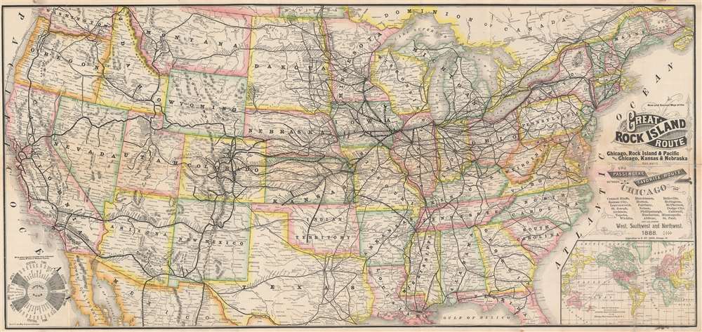
This is an 1888 George F. Cram and Rock Island Railroad map of the United States. Centered on the railroad network of the 'Chicago, Rock Island, and Pacific Railroad', every stop from Chicago to Omaha is labeled. The same detail is present along the lines of the 'Chicago, Kansas, and Nebraska Railway'. The rest of the transcontinental railroad network is illustrated as well, with the Union Pacific, Northern Pacific, Southern Pacific, and the Denver and Rio Grande noted. An inset map situated in the lower right details the global trade network operated 'via the Chicago, Rock Island, and Pacific Railway'.
The Chicago, Rock Island, and Pacific Railroad
The Chicago, Rock Island, and Pacific Railroad operated in the central United States from Chicago to New Mexico. Founded in February 1847 as the Rock Island and La Salle Rail Road Company, the Chicago and Rock Island Railroad was incorporated on February 7, 1851. In 1866, the CRI acquired the Mississippi and Missouri Railroad Company, which connected Davenport and Council Bluffs, Iowa. With that acquisition, the CRI rebranded as the Chicago, Rock Island, and Pacific Railroad Company. Further acquisitions, including the Chicago, Kansas, and Nebraska Railway (which was essentially owned by the Chicago, Rock Island, and Pacific from its inception), allowed the Rock Island to expand its coverage further. The railroad operated until March 31, 1980, when it folded after suffering bankruptcy and strikes.Publication History and Census
This map was created by George Cram and published by Everitte St. John of the Rock Island Railroad in 1888. Several similar editions of this map were published in the 1880s, although the titles varied. Examples are scarce.CartographerS
George Franklin Cram (May 20, 1842 - 1928) was an American map publisher active in the late 19th and early 20th centuries. During the American Civil War, Cram served as a staff cartographer for the Union General Ulysses S. Grant and participated in Sherman's 'March to the Sea'. In 1867, after being discharged from the army, George Cram moved to Chicago, where he founded 'Blanchard and Cram' with his uncle Rufus Blanchard Evanston. Blanchard and Cram was a supply house for the book trade - though they also published a few maps during this period. This short lived business was destroyed in the 1871 by the Great Chicago Fire. After the fire, recognizing a business opportunity in the burgeoning railroad industry, Cram reinvented himself as cartographic publisher, opening the Cram Map Depot. Like fellow Chicago publisher Rand McNally, Cram took advantage of the economical wax engraving processes to inexpensively produce maps in vast quantities. His signature publication, the Unrivaled Atlas of the World became the world's best-selling atlas and was published from the 1880s to 1952. On retiring in 1921, Cram sold his company to Edward A. Peterson of the National Map Company (Scarborough Company). Peterson moved the company to Indianapolis where, following Cram's death, he rebranded the National Map Company as the George F. Cram Company, surely thinking to capitalize on the established identity of the firm. In 1930 he entered the globe market for which the firm was best known from the mid-20th century. In time the firm expanded globally passing becoming a major concern. Loren B. Douthit became company president in 1968 and the Douthit family ran the business until Herff Jones, Inc., bought the company in 2005. More by this mapmaker...
Everitte St. John (February 4, 1844 - April 21, 1908) was an American businessman and railroad executive. St. John began working for the Rock Island system in 1863, an association that lasted thirty-one years. Eventually, he became general manager of the Rock Island. He served as chairman of the General Managers's Association of all the railroads entering Chicago and held that position during the 1894 Pullman strike. He resigned in 1894 to become the vice-president and general manager of the Seaboard Air Line. He retired in 1901. He married Emmelina Lamson on February 4, 1869, his twenty-fifth birthday. Learn More...
Condition
Good. Exhibits wear and toning along original fold lines. Areas of infill at some fold intersections and along margins. Old repairs evident on front of map in title. Time table printed on verso.