
1942 Royal Hungarian Institute of Military Cartography Map of the Rodna Mountains

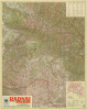
Radnai Havasok.
Romania's 'Hungarian Lands'.
- Digital Map Information
- Suitable for large format printing
- File Size: 80.99 MB
- File Type: ZIP / TIFF
- ICC color profile embedded
- Delivered instantly via download link
Romania's 'Hungarian Lands'.
This is a large-format 1942 map of the Rodna Mountains in the Eastern Carpathians produced by the Royal Hungarian Institute of Military Cartography. An example of wartime cartographic propaganda, the map both reflected and helped cement the control of this region by Hungary, to which it was granted in the Second Vienna Award of 1940, an 'agreement' brokered by Nazi Germany and Fascist Italy.A Closer Look
This map covers the Rodna Mountains in Northern Transylvania (known as Észak-Erdély in Hungarian and Ardealul de Nord in Romanian), an exceptionally beautiful area popular with hikers. It covers from the area around Baia Mare (Nagybánya) and Sighetu Marmației (Máramarossziget) as far south-eastwards as Deda, Aluniș (Magyaró), and Târgu Mureș (Marosvásárhely). Nominally a tourist map that would be highly useful for hikers, it also links directly to a political lightning rod in relations between Hungary and Romania at the time (discussed below). An extensive legend at top-right in Hungarian, German, Italian, and Romanian explains symbols for tourist offices, roads, railways, spas, hunting lodges, and other features. At the bottom right is an inset map of rail and road connections leading into Northern Transylvania (across what was previously and afterwards the border between Hungary and Romania), as well as a Hungarian table of abbreviations.The Second Vienna Award of 1940
The Second Vienna Award (August 30, 1940) was a territorial arbitration imposed by Nazi Germany and Fascist Italy that required Romania to cede northern Transylvania to Hungary. The decision was part of Axis efforts to manage tensions among their allies and maintain regional stability in Eastern Europe during World War II (1939 - 1945). The background lies in the breakup of the Austro-Hungarian Empire and the post-World War I (1914 - 1918) Treaty of Trianon (1920), which had transferred Transylvania from Hungary to Romania, leaving large Hungarian-speaking populations within Romania's borders. In 1940, amid growing Axis influence and the collapse of French and British power (the countries had 'guaranteed' Romania's territorial integrity along with Poland's in March 1939), both Hungary and Romania turned to Germany and Italy to arbitrate their competing claims. At the time, Romania was embroiled in similar territorial disputes with the Soviet Union and Bulgaria, and in both cases, it also surrendered territory rather than fight an unwinnable war.The Second Vienna Award gave Hungary about 43,000 square kilometers of territory with roughly 2.6 million inhabitants, about half of whom were ethnic Romanians. The award caused deep resentment in Romania and pushed the country further into the Axis camp in hopes of regaining its lost lands. For Hungary, it was seen as a partial revision of the Trianon borders, though it also drew the country deeper into dependence on Germany. The Second Vienna Award was revoked after World War II when, in 1947, the Paris Peace Treaties restored northern Transylvania to Romania (this decision was aided by the fact that a coup overthrew Romania's Nazi-aligned government in August 1944 and the country switched sides in the closing months of the conflict).
Publication History and Census
This map was prepared in 1942 by the Royal Hungarian Institute of Military Cartography (Magyar Királyi Honvéd Térképészeti Intézet). It was part of a series of wartime maps prepared by the Institute (which includes two others also offered by us, Szekelyfold-magyar-1942 and Karpatalja-magyar-1940). This map is only noted among the holdings of Oxford University and the Biblioteca Centrală Universitară 'Lucian Blaga' in the OCLC.Cartographer
Magyar Királyi Állami Térképészet (1867 - 1952), translated 'Royal Hungarian State Cartography,' was a Hungarian government map publishing house active in the early 20th century. The organization can trace its origins to the Austro–Hungarian Compromise of 1867, which gave Hungary marginal independence with the right to establish its own civil cartography - thus issuing tourist maps, school maps, cadastral plans, etc. Austria retained jurisdiction over more detailed topographical cartography. This changed in 1918, during World War I (1914 - 1918), when Hungarian military leadership commissioned Colonel Lajos Hajts (1866 - 1933), professor of the Ludovika Military Academy, to lay the framework for a Hungarian State Cartography. This led to the formation of the Hungarian Military Mapping Group (Magyar Katonai Térképező) on February 4, 1919. This organization followed the Austrian Militärgeographisches Institut model. In 1922, the name changed to Magyar Királyi Katonai Állami Térképezet (Royal Hungarian State Mapping Institute). In 1938, the name changed again to Magyar Királyi Honvéd Térképészeti Intézet (Royal Hungarian Institute of Military Cartography). The Honvéd Térképészeti Intézet was folded into the Soviet-style Ministry of Defense in 1952. Further Details...
Condition
Very good. Verso repairs to fold separations.
References
OCLC 1303901208.