This item has been sold, but you can get on the Waitlist to be notified if another example becomes available, or purchase a digital scan.
1749 Vaugondy Map of Iran and Central Asia
RoyaumePerse-vaugondy-1749$87.50

Title
Royaume de Perse. Par le Sr. Robert de Vaugondy, fils de Mr. Robert Geog. du Roi
1749 (dated) 6.5 x 7 in (16.51 x 17.78 cm) 1 : 14400000
1749 (dated) 6.5 x 7 in (16.51 x 17.78 cm) 1 : 14400000
Description
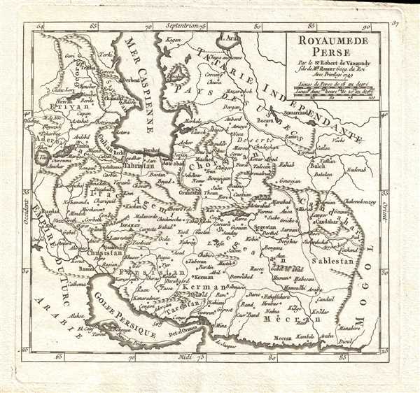
This is a 1749 Didier Robert de Vaugondy map of Iran and Central Asia. The map depicts from the Ottoman Empire (Iraq) to the Afghan/Indian border and from the Aral Sea and the Caucasus to the Persian Gulf. The Ottoman Empire (Empire du Turc) and Arabia dominate the left side of the map, although Azerbaijan and Georgia are labeled. Iraq (Irac) is labeled, and Baghdad (Bagdad) is present very close to the left border. The Caspian Sea functions as the focal point of the map, descending from the upper border through approximately one third of the map. The Aral Sea is depicted along the top border, but here it is referred to as a lake.
Central Asia is labeled as 'Independent Tartary' (Tatarie Independante) which is comprised by Uzbek Country (Pays des Usbecs). Khorasan (Chorasan) and the great city of Balkh (Balch) are both labeled. The Ancient Greeks knew Balkh as Bactra, and Marco Polo referred to Balkh as 'a great a noble city.' Kandahar (Candahar), one of the major cities in modern Afghanistan, functions here as the name of a city and a region.
In Persia, what is now modern-day Iran, several key cities are labeled. Isfahan (Ispahan) is labeled in bold, block lettering, declaring it's importance to the region. It twice served as the capital of the Persian dynasties, and was particularly respected during the 16th and 17th centuries. Alas, in 1775, the capital was moved from Isfahan to several cities, before finally staying in Tehran. Hormuz (Ormus) and the Strait of Hormuz are both labeled here. The Strait of Hormuz functions as a bottleneck into the Persian Gulf (Golfe Persique), making it one of the most strategic locations in the world today.
Several rivers are depicted, although none of them are labeled. Political divisions are presented through dotted lines, as on all the maps in Vaugondy's Atlas Universel, Portatif et Militaire. Several smaller lakes are labeled, including Lake Van and Lake Chahi as are myriad cities and towns.
This map was published by Gilles Robert de Vaugondy in his Atlas Universel, Portatif et Militaire in the 1749 edition.
Cartographer
Robert de Vaugondy (fl. c. 1716 - 1786) was French may publishing from run by brothers Gilles (1688 - 1766) and Didier (c. 1723 - 1786) Robert de Vaugondy. They were map publishers, engravers, and cartographers active in Paris during the mid-18th century. The father and son team were the inheritors to the important Nicolas Sanson (1600 - 1667) cartographic firm whose stock supplied much of their initial material. Graduating from Sanson's maps, Gilles, and more particularly Didier, began to produce their own substantial corpus. The Vaugondys were well-respected for the detail and accuracy of their maps, for which they capitalized on the resources of 18th-century Paris to compile the most accurate and fantasy-free maps possible. The Vaugondys compiled each map based on their own geographic knowledge, scholarly research, journals of contemporary explorers and missionaries, and direct astronomical observation. Moreover, unlike many cartographers of this period, they took pains to reference their sources. Nevertheless, even in 18th-century Paris, geographical knowledge was limited - especially regarding those unexplored portions of the world, including the poles, the Pacific Northwest of America, and the interiors of Africa, Australia, and South America. In these areas, the Vaugondys, like their rivals De L'Isle and Buache, must be considered speculative or positivist geographers. Speculative geography was a genre of mapmaking that evolved in Europe, particularly Paris, in the middle to late 18th century. Cartographers in this genre would fill in unknown lands with theories based on their knowledge of cartography, personal geographical theories, and often dubious primary source material gathered by explorers. This approach, which attempted to use the known to validate the unknown, naturally engendered rivalries. Vaugondy's feuds with other cartographers, most specifically Phillipe Buache, resulted in numerous conflicting papers presented before the Academie des Sciences, of which both were members. The era of speculative cartography effectively ended with the late 18th-century explorations of Captain Cook, Jean Francois de Galaup de La Perouse, and George Vancouver. After Didier died, his maps were acquired by Jean-Baptiste Fortin, who in 1787 sold them to Charles-François Delamarche (1740 - 1817). While Delamarche prospered from the Vaugondy maps, he defrauded Vaugondy's window Marie Louise Rosalie Dangy of her rightful inheritance and may even have killed her. More by this mapmaker...
Source
Robert de Vaugondy, G., Atlas Portatif, Universel, et Militaire, (Paris: Vaugondy, Durand, Pissot) 1749.
Condition
Very good. Blank on verso. Original press mark visible.
References
Pedley, M. S., Bel et Utile, p. 198, 388. OCLC 159769840.