This item has been sold, but you can get on the Waitlist to be notified if another example becomes available, or purchase a digital scan.
1812 Lapie and Tardieu Wall Map of Russia made for Napoleon
Russia-tardieu-1812$2,250.00

Title
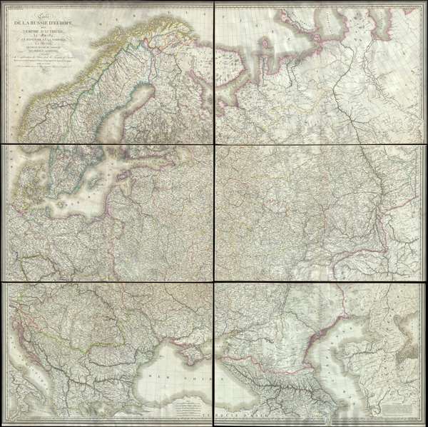
Carte de la Russie d'Europe, avec l'Empire d'Autriche, la Suede, le Danemark et la Norwege, la Prusse, le Grand Duche de Varsovie, les provinces Illyriennes, et une partie de la Confederation du Rhin et de la Turquie d'Europe.
1812 (dated) 64.5 x 64.5 in (163.83 x 163.83 cm) 1 : 2300000
1812 (dated) 64.5 x 64.5 in (163.83 x 163.83 cm) 1 : 2300000
Description
This extraordinary six-sheet 1812 wall map of Russia was prepared by Pierre M. Lapie and Pierre Antoine-François Tardieu in anticipation of Napoleon's catastrophic 1812 French Invasion of Russia. Centered on Moscow (Moscau), the map depicts European Russia and adjacent parts of Eastern Europe from Scandinavia and the Adriatic to the Aral Sea and the Tobol River. Cartographically the map is based upon earlier Russian surveys smuggled out of the official Russian map depository in St. Petersburg. Consequently, the accuracy and detail throughout is staggering. The map illustrates towns, road networks, political divisions, topography, and more – everything a conquering general would need to know to effectively execute his invasion plan.
The French Invasion of Russia (June 1812 – December 1812)
Known in Russia as the Patriotic War of 1812, the French Invasion of Russia began on June 24, 1812, when Napoleon Boneparte's Grande Armée crossed the Neman River in an attempt to engage the Russian army. Napoleon's goal was to force Tsar Alexander I to end trade with Britain, thus positioning England to sue for peace. Napoleon also recognized the massive agricultural potential of Russia to feed his gigantic armies. With more than 680,000 soldiers, the Grande Armée was the largest military force ever assembled. Napoleon aggressively pushed into Russia, winning a number of minor victories, but the continually retreating Russian forces denied him the kind of all out battles that allowed his strategic and tactical genius to shine. Instead, the Russian army left behind a scorched earth wasteland, burning farms, villages, towns, and crops, forcing the French army to rely upon a vulnerable and floundering supply train that stretched all the way back to western Europe. Napoleon's army eventually entered Moscow, only to find that it too had been burned and abandoned. After waiting in Moscow for roughly a month on the assumption that the Russians were about to surrender, Napoleon, recognizing that his army had run out of food, ordered a retreat. Russian forces harried them the entire way. They were also suffering from disease, starvation, and the onset of the bitter Russian winter – for which they were woefully unprepared. When the remnants of Napoleon's main army crossed the Berezina River in late November, only about 27,000 effective soldiers remained. The defeat marked a turning point in the Napoleonic Wars. For the first time, Bonaparte was seen as vulnerable. His erstwhile allies, Prussia and Austria, turned on him, trigging the War of the Sixth Coalition and Napoleon's defeat in 1814.
This map was drawn by Pierre M. Lapie and engraved by Pierre Antoine-François in 1812. The map is quite rare on the market and an essential piece for any collection relating to the Napoleonic Wars.
CartographerS
Pierre M. Lapie (fl. 1779 - 1850) and his son Alexandre Emile Lapie (fl. 1809 - 1850) were French cartographers and engravers active in the early part of the 19th century. The Lapies were commissioned officers in the French army holding the ranks of Colonel and Capitan, respectively. Alexander enjoyed the title of "First Geographer to the King", and this title appears on several of his atlases. Both father and son were exceptional engravers and fastidious cartographers. Working separately and jointly they published four important atlases, an 1811 Atlas of the French Empire (Alexander), the 1812 Atlas Classique et Universel (Pierre), the Atlas Universel de Geographie Ancienne et Modern (joint issue), and the 1848 Atlas Militaire (Alexander). They also issued many smaller maps and independent issues. All of these are products of exceptional beauty and detail. Despite producing many beautiful maps and atlases, the work of the Lapie family remains largely underappreciated by most modern collectors and map historians. The later 19th century cartographer A. H. Dufour claimed to be a student of Lapie, though it is unclear if he was referring to the father or the son. The work of the Lapie firm, with its precise engraving and informational density, strongly influenced the mid-19th century German commercial map publishers whose maps would eventually dominate the continental market. More by this mapmaker...
Pierre Antoine-François Tardieu (February 17, 1757 - January 14, 1822), also known as Tardieu de l'Estrapade, for his address at Place de L'Estrapade, was a French geographical engraver and publisher active in Paris during the late 18th and early 19th centuries. A member of the large and prolific Tardieu family, which, for over 200 years, produced multiple skilled and active engravers. A disciple of his uncle Pierre-François Tardieu, in his youth Antoine-Francois would sign his works Pierre-François (or P.F. Tardieu; 1711 - 1771) , but later in his career began using his own name or (P.A.F. Tardieu). His two sons, Pierre-Antoine Tardieu and Ambroise Tardieu (1788 - 1841), both became noted geographical engravers in the own right. Learn More...
Condition
Very good. Six unjoined sections on heavy paper. Some toning. Accompanied by original binder.
References
Rumsey 13035.000. OCLC 5474548.