1861 Murray Map of Central Asia
RussianChineseFrontier-murray-1861$575.00

Title
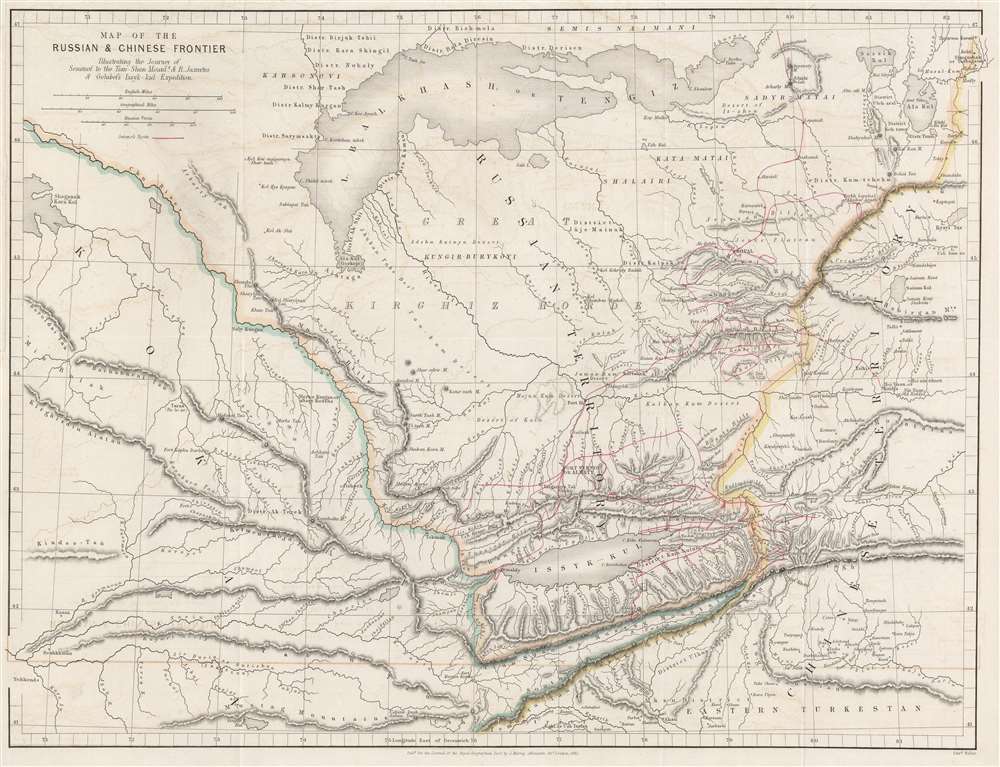
Map of Russian and Chinese Frontier Illustrating the Journey of Semenof to the Tian-Shan Mounts. and R. Jaxartes and Golubof's Issyk-kul Expedition.
1861 (dated) 14 x 18.25 in (35.56 x 46.355 cm) 1 : 2112000
1861 (dated) 14 x 18.25 in (35.56 x 46.355 cm) 1 : 2112000
Description
This is an 1861 John Murray map of Central Asia tracing Pyotr Semyonov's (1827 - 1914) first European ascent into the Tian Shan Mountains. The map depicts the region from Lake Balkash south to the Tian Shan Mountains, encompassing modern-day Kyrgyzstan, Kazakhstan, and western China - at the time considered one of the most remote and inaccessible parts of the world.
The Semyonov Expedition to the Tian Shan Mountains
A red line traces the Russian mountaineer Pyotr Petrovich Semyonov Tyan-Shansky's (Пётр Петрович Семёнов-Тян-Шанский; 1827 - 1914) 1857 expedition into the heart of the Tian Shan Mountains, which he undertook at the suggestion of the German naturalist Alexander von Humbolt (1769 - 1859), under whom he studied geography in Berlin. Pyotr visited the Eastern Kyrgyzstan Lake Issyk Kul, the world's second-largest saltwater lake, and then explored the interior of the Tian Shan Range. He became the first European to look on the dramatic Tengri Tag (Mountains of Heaven) panorama and see the second highest peak, Khan Tengri. Semyonov published the first systematic description of the region in 1858 to immediate international acclaim. His monograph was so influential and career-defining that fifty years later Czar Nicholas II of Russia authorized Semyonov to 'Tian-Shansky' (of the Tian Shan) to his name.Publication History and Census
This map was created by John Murray and engraved by Edward Weller for publication in Volume Thirty-One of The Journal of the Royal Geographical Society in 1861. The present map is extremely scarce and is not cataloged in OCLC.CartographerS
John Murray (March 3, 1841 - March 16, 1914), considered the father of modern oceanography, was a British oceanographer, limnologist, and marine biologist. Born at Cobourg, Canada West, Murray attended school in London, Ontario, and later Cobourg College. He returned to Scotland in 1858 (his parents had emigrated from Scotland to Canada around 1834) to continue his education at Stirling High School and live with his grandfather. He enrolled at the University of Edinburgh in 1864 with the intention of studying medicine, but he did not finish his studies and did not graduate. Instead, he joined the crew of a whaling ship, the Jan Mayen, as the ship's surgeon and spent the seven-month voyage collecting marine specimens and recording data on ocean currents, ice movements, and the weather. He returned to Edinburgh later that year and reenrolled at the University to study geology, graduating in 1872. That same year, Murray joined the Challenger Expedition as a naturalist and spent the four-year voyage assisting in the research of the oceans. After the expedition's return, Murray was made a Chief Assistant at the Challenger offices and he managed and organized the expedition's collections. He became Director of the office in 1882 after the death of the expedition's chief scientist, Charles Wyville Thomson, and published The Report on the Scientific Results of the Voyage of HMS Challenger in 1896, which consisted of more than fifty volumes. Murray established the Marine Laboratory at Granton, Edinburgh, in 1884, the first laboratory of its kind in the United Kingdom. The lab was moved to Millport in 1894 and became the University Marine Biological Station, Millport, which is known today as the Scottish Association for Marine Science. Murray proposed an oceanographic expedition to the North Atlantic in 1909 and agreed to pay all the expenses. The Norwegian government, in turn, lent him the research ship Michael Sars and its scientific crew. The expedition was joined by Norwegian marine biologist Johan Hjort and set out in April 1910. It spent four months taking physical and biological observations at all depths between Europe and North America, and Murray and Hjort published The Depths of the Ocean with their findings in 1912, a book that became a classic for marine naturalists and oceanographers. Murray was killed on March 16, 1914, when his car overturned ten miles west of his home. More by this mapmaker...
Edward Weller (July 1, 1819 - 1884) was a cartographer and engraver based in London. Weller was a nephew of another well-known map publisher Sidney Hall (1788 - 1831), who gave him 50 Pounds to pay his apprenticeship fees. He engraved for many prominent mapmakers and was active enough in the community to be recommended for membership to the Royal Geographical Society in 1851 on the recommendation of John Arrowsmith, among others. He eventually inherited the Sidney Hall map business which led him to follow Arrowsmith as the unofficial geographer to the Royal Geographical Society. Weller was among the first map printers in London to embrace lithography. His best known work appears in Cassell's Weekly Dispatch Atlas, published in monthly segments for subscribers of the 'Weekly Dispatch' newspaper. This collection of maps eventually grew to include much of the known world. Published in various editions from 1855 through the early 1880s. Weller died in May of 1884, leaving behind a successful business and an unhappy widow. His son, Francis Sidney Weller (1849 - 1910), followed in his father's footsteps and continued the family map business. The atlas Mackenzie's Comprehensive Gazetteer of England and Wales was published in 1894 and bore F. S. Weller's signature on the maps. Learn More...
Royal Geographical Society (fl. 1830 - present) is a British Society established in 1830 to promote geographical science and exploration. Originally titled the "Geographical Society of London", the RGS received its royal charter from Queen Victoria in 1859 shortly after absorbing several similar but more regional societies including the African Association, the Raleigh Club and the Palestine Association. The RGS sponsored many of the most important and exciting voyages of exploration ever undertaken, including the exploration of Charles Darwin, David Livingstone, Robert Falcon Scott, Richard F. Burton, John Speke, George Hayward, H. M Stanley, Ernest Shackleton and Sir Edmond Hillary. Today, the RGS remains a leading global sponsor of geographical and scientific studies. The Society is based in Lowther Lodge, South Kensington, London. Learn More...
Source
The Journal of the Royal Geographical Society, Vol. 31, (London: John Murray), 1861.
Condition
Very good. Exhibits light wear along original fold lines. Some offsetting. Left margin extended. Blank on verso.