1722 Nicolas De Fer Map of Russia in Asia, updating Witsen
RussianEmpire-fer-1722$3,000.00


Title
Les etats du Czar ou Empereur des Russes en Europe et en Asie...
1722 (dated) 17 x 25.25 in (43.18 x 64.135 cm) 1 : 11734800
1722 (dated) 17 x 25.25 in (43.18 x 64.135 cm) 1 : 11734800
Description
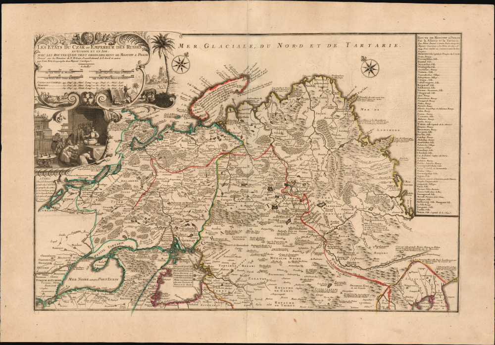
This large, beautiful, and rare map of the Russian Empire, engraved by Nicolas de Fer and published in 1722, is a fascinating revision of Nicolas Witsen's 1687 map of the Tatar Empire and Siberia. It incorporates the novel reports of Evert Ysbrandzoon Ides - derived from his journeys between Moscow and China - as well as the Central Asian voyage of Philippe Avril.
The path taken by Ides on his 1692 embassy is traced from Moscow to the Ob River and east to Lake Baikal. From there, the track leads to Nerchinsk (Nerzinskoi) on the frontier with China, and then south through Chinese Tartary, crossing the Great Wall, to Peking. The map's conic projection - not apparent, given the lack of latitude or longitude lines - is illustrated by the placement of two separate compass roses at sharply different angles in the sea north of Tartary.
The detail for the southern portion of the map, between the Caspian Sea and China, is distinctive and different from either Witsen's or Ides' map. It is derived from Philippe Avril's abortive attempt at a land voyage to China in the 1680s. His journey took him to Armenia, Astrakhan, Kurdistan, and Persia before he was diverted north to Moscow and then ejected to Poland. He published a report of the journey on his return to Europe.
A Closer Look
The map presents Russia in Asia from the Empire's western border with Sweden, Livonia, and Lithuania eastwards to highly conjectural Arctic and Pacific coastlines. The map's scope includes Nova Zembla in the north whilst reaching southwards to the Black and Caspian Seas, Persia, and the Mogul Empire (northern India, Pakistan, and Afghanistan). In the southeast, China and Korea are recognizable.The path taken by Ides on his 1692 embassy is traced from Moscow to the Ob River and east to Lake Baikal. From there, the track leads to Nerchinsk (Nerzinskoi) on the frontier with China, and then south through Chinese Tartary, crossing the Great Wall, to Peking. The map's conic projection - not apparent, given the lack of latitude or longitude lines - is illustrated by the placement of two separate compass roses at sharply different angles in the sea north of Tartary.
The Sources
In 1692, Peter the Great sent Ides as an envoy to Kangxi China in the wake of the 1689 Treaty of Nerchinsk. Ides produced a map in 1704 to accompany his report. Although Ides credited his map to Nicolaes Witsen, his map was more reflective of Russian cartography at the end of the 17th century than Witsen's 1687 map. Bagrow identified its probable source as a Russian chertyozh (technical map), which Witsen hoped that Ides would be able to correct and improve. Bagrow suspected that Ides may have added content not only from his own journeys but also from Russian maps acquired in Moscow. The Russian origin of Ides' map tends to be supported by the rectilinear, primitive form of the maps appearing in the 1704 editions of his travelogue, reflective of Russian conventions at the end of the 17th century. Among the features incorporated in the present Witsen-derived work is the track taken by Ides and his 250-man entourage. Among these was his secretary, Adam Brand (1692 - 1746), who published his own account of the journey. A table on the right lists the itinerary of the expedition according to Brand.The detail for the southern portion of the map, between the Caspian Sea and China, is distinctive and different from either Witsen's or Ides' map. It is derived from Philippe Avril's abortive attempt at a land voyage to China in the 1680s. His journey took him to Armenia, Astrakhan, Kurdistan, and Persia before he was diverted north to Moscow and then ejected to Poland. He published a report of the journey on his return to Europe.
The Cartouche
The map's elegant and decorative cartouche encompasses not only the map's title and scales but also the positions (latitude and longitude) of Constantinople, Moscow, and Peking. In the background to the right, a landscape evokes the central Asian steppes; below the cartouche, a vignette depicts the Ides embassy's petition to the Emperor in Peking.Publication History and Census
This map was drawn in Paris by Nicolas de Fer and printed by his son-in-law and successor Jacques François Bénard in 1722. The map was separately issued and not included in a conventional atlas; consequently, it is extremely scarce. We see just ten examples in institutional collections and price records, with only three examples having come to market over the past 40 years.CartographerS
Nicholas de Fer (1646 - October 25, 1720) was a French cartographer and publisher, the son of cartographer Antoine de Fer. He apprenticed with the Paris engraver Louis Spirinx, producing his first map, of the Canal du Midi, at 23. When his father died in June of 1673 he took over the family engraving business and established himself on Quai de L'Horloge, Paris, as an engraver, cartographer, and map publisher. De Fer was a prolific cartographer with over 600 maps and atlases to his credit. De Fer's work, though replete with geographical errors, earned a large following because of its considerable decorative appeal. In the late 17th century, De Fer's fame culminated in his appointment as Geographe de le Dauphin, a position that offered him unprecedented access to the most up to date cartographic information. This was a partner position to another simultaneously held by the more scientific geographer Guillaume De L'Isle, Premier Geograph de Roi. Despite very different cartographic approaches, De L'Isle and De Fer seem to have stepped carefully around one another and were rarely publicly at odds. Upon his death of old age in 1720, Nicolas was succeeded by two of his sons-in-law, who also happened to be brothers, Guillaume Danet (who had married his daughter Marguerite-Geneviève De Fer), and Jacques-François Bénard (Besnard) Danet (husband of Marie-Anne De Fer), and their heirs, who continued to publish under the De Fer imprint until about 1760. It is of note that part of the De Fer legacy also passed to the engraver Remi Rircher, who married De Fer's third daughter, but Richer had little interest in the business and sold his share to the Danet brothers in 1721. More by this mapmaker...
Nicolaes Witsen (May 8, 1641 - August 10, 1717) was a Dutch cartographer, diplomat, writer, businessman, and politician. Witsen was born in Amsterdam to the politically powerful Cornelius Jan Witsen, burgomaster, head bailiff and administrator of the Dutch West India Company. Witsen studied Law at the University of Leiden where he developed an interest in language and maps. He was highly educated and traveled in elite circle, befriending Oliver Cromwell, Andrew Vinius, Cosimo III de'Medici, Melchisédech Thévenot, and others. In 1662 he presented a paper at the Amsterdam Athenaeum Illustre arguing for the effect of comets on earthly life. Witsen joined the VOC (Dutch East India Company) became an expert on shipbuilding, composing several treatises on the subject. His passion, however, remained cartography, particularly the cartography of Asia. Having traveled in embassy to Russia, Witsen contrived to get special access to Russian records on the exploration of Siberia, including the heretofore unknown explorations of Semyon Dezhnev. He also acquired the diary of Maarten Gerritsz Vries, who had explored the coast of Sakhalin in 1643. The Vries diary was thereafter lost. This information he compiled into several influential maps and books on Asia which were extensively copied. One result of this work is the Witsen Peninsula - a narrow outcropping of land extending from Siberia that appears on many maps of the early 17th century. Later, Witsen became Mayor of Amsterdam, a position he held some 13 times, and under whose tenure arts flourished. Witsen died in Amsterdam and was buried near his country home in Egmond aan den Hoef. Learn More...
Eberhard Isbrand Ides (1657 - 1708) was a Dutch - Danish merchant, traveler and diplomat. Little is known of his youth and education, but by 1677 he was trading with, and traveling to Russia; it is known that in 1687 he had settled in the German Quarter of Moscow. Following the 1689 Treaty of Nerchinsk, he accompanied a Russo-German embassy to Kangxi China, in order to develop trade relations between the two empires. After returning, he engaged in projects modernizing Russia's military and Navy, eventually becoming a commissioner of the Russian Admiralty, and an administrator of export tariffs for the port of Arkhangelsk. His travels to China were aided by a Russian map of East Asia supplied him by Nicolas Witsen, which the Dutch scholar-statesman hoped Ides would correct; he would soon have his own information to add, being one of the first Europeans to describe the Gobi Desert firsthand. In 1704 which included his map. Different editions of Ides' Dreyjährige Reise nach China featured examples of the map engraved by an array of mapmakers: Halma did one of the Dutch editions and an English one; the Frankfurt edition of 1707 included a map engraved by Homann. Learn More...
Philippe Avril (September 16, 1654 - c. 1698) was a French Jesuit missionary and an explorer. Born in Angoulême, France, his early life and education is not known. When the Jesuit order sent him to China he had been serving in Paris as a professor of philosophy and mathematics. Verbiest, already posted to China, had sent instructions for Avril to follow a land route to join him. This resulted in a six-year journey along the Silk Road: he passed through Armenia (in 1685) then Astrakhan, Kurdistan, and Persia on his odyssey. His travels took him to Moscow, and then a detour: he was refused passage through Tatary, and was sent by Russia to Poland. He attempted China again, but his ship was lost at sea in 1698, and he never reached China. Learn More...
Condition
Very good. Mended fold split at bottom impacting image with no loss. Minor mend to top border with no loss. Else excellent with original outline color.
References
OCLC 316449426. Bagrow, Leo, A History of the Cartography of Russia up to 1800.p. 93, footnote 128.