
This item below is out of stock, but another example (left) is available. To view the available item, click "Details."
Details
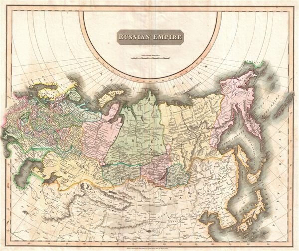
1814 Thomson Map of the Russian Empire in Europe and Asia
$300.00
1814 Thomson Map of the Russian Empire in Europe and Asia
RussianEmpire-thomson-1814$150.00

Title
Russian Empire.
1814 (dated) 20 x 24 in (50.8 x 60.96 cm)
1814 (dated) 20 x 24 in (50.8 x 60.96 cm)
Description
This large 1814 atlas map depicts the Russian Empire in its entirety, both in Europe and in Asia as well as adjacent parts of Tartary, Chinese Tartary, Japan, Korea, and the Gobi. In 1815 Tsarist Russia emerged from the Napoleonic Wars economically insolvent and politically fearful of the Revolutionary fervor that had just swept through Europe. In order to shore up Russia's economic position, the Tsars began an aggressive series of expansions into the Caucuses and Central Asia that would vastly increase the landmass of the Russian Empire. The long-disputed sea between Korea and Japan is identified as the 'Sea of Japan.' Thomson maps are known for their stunning color, awe inspiring size, and magnificent detail. Thomson's work, including this map, represents some of the finest cartographic art of the 19th century. Engraved by N.R. Hewitt, 10 Broad Street, London, and issued as plate no. 7 in Edinburgh cartographer John Thomson's 1817 edition of the New General Atlas.
Cartographer
John Thomson (1777 - c. 1841) was a Scottish cartographer, publisher, and bookbinder active in Edinburgh during the early part of the 19th century. Thomson apprenticed under Edinburgh bookbinder Robert Alison. After his apprenticeship, he briefly went into business with Abraham Thomson. Later, the two parted ways, John Thomson segueing into maps and Abraham Thomson taking over the bookbinding portion of the business. Thomson is generally one of the leading publishers in the Edinburgh school of cartography, which flourished from roughly 1800 to 1830. Thomson and his contemporaries (Pinkerton and Cary) redefined European cartography by abandoning typical 18th-century decorative elements such as elaborate title cartouches and fantastic beasts in favor of detail and accuracy. Thomson's principle works include Thomson's New General Atlas, published from 1814 to 1821, the New Classical and Historical Atlas of 1829, and his 1830 Atlas of Scotland. The Atlas of Scotland, a work of groundbreaking detail and dedication, would eventually bankrupt the Thomson firm in 1830, at which time their plates were sequestered by the court. The firm partially recovered in the subsequent year, allowing Thomson to reclaim his printing plates in 1831, but filed again for bankruptcy in 1835, at which time most of his printing plates were sold to A. K. Johnston and Company. There is some suggestion that he continued to work as a bookbinder until 1841. Today, Thomson maps are becoming increasingly rare as they are highly admired for their impressive size, vivid hand coloration, and superb detail. More by this mapmaker...
Source
Thomson, J. A New General Atlas, (Edinburgh) 1814.
Condition
Very good condition. Original centerfold exhibits some light toning . Stains in the upper middle.
References
Rumsey 1007.039. Phillips (Atlases) 731. Newberry Library: Ayer 135 T4 1817.