1887 Bradley Map of European Russia, Scandinavia, Holland, Belgium and Denmark.
RussiaSwedenNorway-bradley-1887$100.00

Title
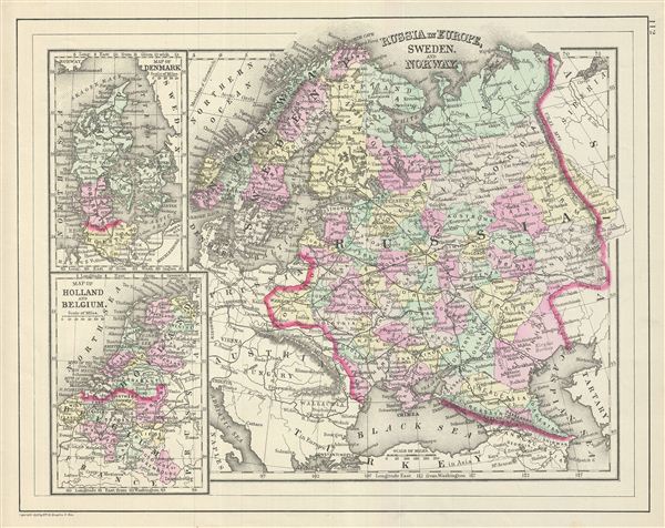
Russia in Europe, Sweden and Norway. Map of Denmark. Map of Holland and Belgium.
1887 (dated) 11.5 x 14.5 in (29.21 x 36.83 cm)
1887 (dated) 11.5 x 14.5 in (29.21 x 36.83 cm)
Description
This is a fine example of William M. Bradley's 1887 map of Russia, Norway, Sweden, Holland Belgium and Denmark. Maps of Denmark, Holland and Belgium relegated to insets on the left hand side of the sheet. The larger map covers Scandinavia and the european portion of Russia from the Arctic Ocean to Turkey, including the european portions of Russia as well as Finland, Ukraine, Latvia, Lithuania and estonia. Denmark is covered in full, from the Skagerrak to the Baltic Sea. Holland and Belgium are covered from the North Sea to France.
Russia at this time was under the suzerainty of Tzar Alexander the II. Alexander is best known for his liberal reforms including the emancipation Reform of 1861. The Reform, considered the most important event in 19th century Russian history, liberated Russia's countless serfs. In 1830, the Belgian Revolution led to the secession of Belgium from the United Kingdom of Netherlands into the independent Kingdom of Belgium. Though Belgium had successfully made itself independent, the Netherlands refused to recognize the new country until the 1839 Treaty of London. Meanwhile Scandinavia and Denmark at the time were in the midst of a prolonged period of peace and prosperity that led to a cultural and economic boom.
Various towns, cities, rivers and an assortment of additional topographical details are noted. Map is color coded according to regional and political boundaries with elevation rendered by hachure. Copyrighted 1887 by Wm. M. Bradley & Bro., for inssue as plate no. 112 in the 1887 edition of Mitchell's New General Atlas.
CartographerS
Bradley, Garretson and Co. (fl. c. 1880 - 1900) were prominent cartographic publishers active in the later part of the 19th century. Bradley acquired Samuel Augustus Mitchell Junior's atlas plates in the late 1880s which he used to publish his own version of Mitchell's atlas. The firm had offices both in Philadelphia, at 66 North Fourth Street, and in Brantford, Ontario. More by this mapmaker...
Samuel Augustus Mitchell (March 20, 1792 - December 20, 1868) began his map publishing career in the early 1830s. Mitchell was born in Bristol, Connecticut. He relocated to Philadelphia in 1821. Having worked as a school teacher and a geographical writer, Mitchell was frustrated with the low quality and inaccuracy of school texts of the period. His first maps were an attempt to rectify this problem. In the next 20 years Mitchell would become the most prominent American map publisher of the mid-19th century. Mitchell worked with prominent engravers J. H. Young, H. S. Tanner, and H. N. Burroughs before attaining the full copyright on his maps in 1847. In 1849 Mitchell either partnered with or sold his plates to Thomas, Cowperthwait and Company who continued to publish the Mitchell's Universal Atlas. By about 1856 most of the Mitchell plates and copyrights were acquired by Charles Desilver who continued to publish the maps, many with modified borders and color schemes, until Mitchell's son, Samuel Augustus Mitchell Junior, entered the picture. In 1859, S.A. Mitchell Jr. purchased most of the plates back from Desilver and introduced his own floral motif border. From 1860 on, he published his own editions of the New General Atlas. The younger Mitchell became as prominent as his father, publishing maps and atlases until 1887, when most of the copyrights were again sold and the Mitchell firm closed its doors for the final time. Learn More...
Source
Huber, John. Mitchell's New General Atlas, containing Maps of the Various Countries of the World, Plans of Cities, Etc., Embraced in Ninty-Three Quarto Maps, forming a series of One Hundred and Forty-seven Map and Plans, together with Valuable Statistical Tables., 1887
Condition
Very good. Blank on verso.
References
Rumsey 0594.061.