
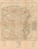
1930 Service Cartographique Map of Central Africa - Congo, Rwanda, Burundi


This item has been sold.
Province orientale et territoires du Ruanda et de l'Urundi.
Height of Belgian Colonialism.
- Digital Map Information
- Suitable for large format printing
- File Size: 43.03 MB
- File Type: ZIP / TIFF
- ICC color profile embedded
- Delivered instantly via download link
Height of Belgian Colonialism.
This is a 1930 Belgian Ministère des Colonies Service Cartographique map of Central Africa covering much of the interior continent. It was produced when Belgium's colonial footprint in Africa was at its height, covering most of the territory seen here.A Closer Look
This map covers a wide portion of central Africa, including the eastern half of today's Democratic Republic of the Congo, Rwanda, and Burundi, along with portions of Tanzania, Uganda, South Sudan, and the Central African Republic. The African Great Lakes appear at right, including Lake Kivu and Lake Tanganyika on the borders of the Congo, Rwanda, Burundi, and Tanzania. Settlements, including large settlements such as Stanleyville (Kisangani), Kigali, and Gitega, are recorded, along with many smaller towns, villages, Catholic and Protestant missions, post offices, and trading posts. Roads and railways (including those under construction), telegraph and telephone lines, administrative boundaries, and waterways are traced throughout.Historical Context
The Interwar period (1918 - 1939) was a transformative and often brutal era for Central Africa, characterized by the consolidation of Belgian colonial power and a shift toward intensive economic exploitation. Under the Treaty of Versailles and subsequent League of Nations mandates, Belgium was granted control over Ruanda-Urundi (modern-day Rwanda and Burundi), territories formerly part of German East Africa. This created a massive, contiguous bloc of Belgian influence in the heart of the continent, governed with a mix of paternalism and social engineering.In the Congo, the Interwar years marked a transition from the chaotic, murderous extraction of the King Leopold Era (the 'Congo Free State,' taken over by the Belgian state in 1908) to a more organized, though still highly coercive, state-managed economy. This 'model colony' period saw the rise of massive mining corporations, such as the Union Minière du Haut-Katanga, which turned the region into a global hub for copper, cobalt, and diamonds. To fuel this industrial machine, the colonial administration enforced 'prestation' (forced labor) and mandatory cultivation policies. Large coffee and cotton plantations were also established for the export of these cash crops. The guiding philosophy of the era was 'dominer pour server,' a Belgian take on the mission civilisatrice. While Belgium invested in some infrastructure (especially railways) and basic healthcare to maintain a healthy labor force, the Congolese were systematically denied access to higher education and political rights. It is no surprise then that this period saw the rise of powerful anti-colonial movements, especially the Kimbanguist movement, a religious and proto-nationalist surge led by Simon Kimbangu, which the Belgians suppressed by imprisoning Kimbangu for thirty years.
In Ruanda-Urundi, the Belgian administration operated differently, utilizing a system of indirect rule. Because the region already had centralized monarchies, the Belgians chose to govern through the existing Tutsi aristocracy, strengthening them vis-à-vis Hutu chiefs. However, they altered the social fabric by solidifying ethnic identities that had previously been more fluid, for instance by instituting identity cards with ethnic identities on them in 1935. Unbeknownst to these colonial officials, they were laying the seeds for the horrific genocide of 1994. This era also saw the massive expansion of the Catholic Church, which took over nearly all education and became a virtual 'state within a state,' explaining the careful notation of Catholic missions on this map.
Publication History and Census
This map was prepared in May 1930 by the Belgian Ministère des Colonies Service Cartographique, one of four sheets covering the Belgian Congo (outlined in a key at bottom here). It was printed by the Imprimerie Lithographique de l'Institut Cartographique Militaire. Three editions of the map are cataloged in institutional collections: an original 1924 edition, a 1928 edition, and this 1930 update, though all are quite rare. The present edition is cataloged at five institutions in the OCLC: the University of Wisconsin - Milwaukee, the Bayerische Staatsbibliothek, the Bibliothèque nationale de France, the ZBW - Leibniz-Informationszentrum Wirtschaft, and the ETH-Bibliothek Zürich.Cartographer
Service Cartographique du Ministère des Colonies (c. 1910 - 1962) was the Belgian colonial cartographic service that produced maps of Belgium's colonial empire, concentrated in central Africa, in the early-mid 20th century. It was formed during the Belgian state's assuming administration over the earlier Congo Free State and carried out important detailed surveys of the Belgian portion of central Africa, which came to include Rwanda and Burundi after the First World War. The Service was most active in the Interwar period and again after the disruptions of the Second World War, producing both topographic maps but also thematic maps on linguistic and ethnic groups, climate, economics, and medical sciecnes. Further Details...
Condition
Good. Toning and light soiling. Wear on original fold lines, with some reinstated loss at a few fold intersections.
References
OCLC 1120936361, 255903063, 494647389, 164578500, 888946992.