
1776 Des Barres Map / Chart of Sable Island (Graveyard of the Atlantic)

[Sable Island.]
Charting the Graveyard of the Atlantic.
- Digital Map Information
- Suitable for large format printing
- Full resolution TIFF file
- ICC color profile embedded
- Delivered instantly via download link
Charting the Graveyard of the Atlantic.
This extraordinary 1776 Joseph Frederick Wallet Des Barres navigational map suite devoted to Sable Island combines the first scientifically surveyed chart of the notorious Atlantic hazard with coastal recognition views and detailed sailing instructions. Sable Island haunted North Atlantic navigation for centuries, appearing on European charts since the early age of transatlantic exploration. Yet, its low profile, shifting sands, enormous surrounding shoals, fog, currents, and violent seas made it extraordinarily difficult to map - and easy to wreck upon. Acting under orders of the British Admiralty, Des Barres spent the summers of 1766 and 1767 surveying the island and its surrounding waters in unprecedented detail. Published for his monumental Atlantic Neptune, these sheets transformed Sable Island from a vaguely understood menace at the edge of earlier charts into a comprehensively documented navigational landscape: charted hydrographically, pictured in profile, and explained in precise sailing instructions.A Closer Look
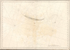
The centerpiece is Des Barres's large untitled hydrographic chart of Sable Island and its surrounding waters. The island's crescent form stretches across the upper portion of the sheet, surrounded by hundreds of depth soundings extending far into the Atlantic. Des Barres meticulously maps the submarine geography that made Sable so dangerous: submerged banks, shoals, channels, and changing depths extending for miles beyond the island.Rhumb lines radiate across the surrounding sea, while scales in statute and nautical miles emphasize the chart's practical navigational purpose. On the island itself, Des Barres records ponds, dunes, wetlands, and the 'Farmhouse,' evidence of contemporary attempts to maintain a human presence on this isolated strip of sand. Yet the extraordinary density of soundings around the island makes clear that the chart's true subject is not Sable Island itself, but the vast and treacherous surrounding maritime environment.
Seeing Sable Before Striking It
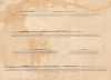
The chart is accompanied by a sheet of five coastal profiles showing Sable Island as it would appear to a mariner approaching from the Atlantic. These recognition views were essential navigational tools in an age before electronic positioning. A navigator might know approximately where Sable Island lay and even recognize approaching depths from his lead line, but identifying the low and visually indistinct island on the horizon remained difficult.Des Barres therefore depicts the island from several directions and distances. The views identify distinctive landmarks including the Naked Sand Hills, Rams Head, and other elevations, allowing navigators to compare the horizon before them with the engraved profiles. Seen alongside the hydrographic chart, the soundings told the navigator what lay beneath his vessel, while the profiles told him what to expect ahead.
For Sable Island, this was particularly important. Its low dunes could be difficult to distinguish from the horizon until a vessel was already dangerously close to the surrounding banks. Des Barres's profiles transformed the island's silhouette into a navigational landmark.
Remarks on the Isle of Sable
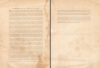
The third component is Des Barres's extensive Remarks on the Isle of Sable, effectively a written pilot accompanying the visual information supplied by the chart and views. It describes tides, currents, depths, bottom composition, shoals, breaking seas, anchorages, landing conditions, and recognizable landmarks, providing practical instructions for vessels approaching or passing the island. The text reveals the complexity of navigating Sable's waters. Des Barres discusses the northeast and northwest bars, changing depths and bottom conditions, the circumstances under which seas break over the banks, and the dangers of approaching without favorable winds. He even explains how the color and character of material brought up by the sounding lead could help navigators determine their position. The Remarks also provide a remarkable contemporary description of Sable itself. Des Barres notes its broken terrain of hills, knobs, cliffs, hollows, and freshwater ponds, along with cranberries, blueberries, juniper, wild peas, and other vegetation. Most evocatively, he records horses, cattle, hogs, and other animals 'running wild upon it' - an extraordinary early reference to the feral animals that would become one of Sable Island's most enduring characteristics.Surveying the Graveyard of the Atlantic
European maps included Sable Island for nearly three centuries before Des Barres surveyed it. But locating the island roughly was very different from understanding the enormous, constantly changing system of banks surrounding it. Its position astride important North Atlantic approaches, combined with fog, storms, strong currents, low visibility, and extensive shoals, made it one of the most feared navigational hazards off northeastern North America.Following Britain's victory in the French and Indian War (1754 - 1763), the Admiralty undertook an ambitious program to improve its knowledge of the North American coastline. Des Barres was charged with surveying Nova Scotia and adjacent waters, including Sable Island, where he worked during the summers of 1766 and 1767. The resulting survey represented a fundamental advance over earlier cartography: for the first time, Sable Island was systematically documented as an integrated navigational problem encompassing shoreline, topography, offshore hydrography, visual recognition, tides, currents, and sailing conditions.
The Atlantic Neptune
Des Barres returned to London in 1774 to oversee the engraving and publication of the extraordinary body of surveys accumulated during the preceding decade. The resulting Atlantic Neptune became one of the great hydrographic achievements of the 18th century. Its charts were particularly important during the American Revolutionary War (1775 - 1783), when detailed knowledge of North American coastal waters had immediate strategic importance to the Royal Navy.The Neptune, however, was not published like a conventional atlas with a fixed complement of maps. Its charts, plans, views, and sailing directions appeared progressively and were assembled into volumes according to availability and the requirements of individual purchasers. Consequently, no standard collation exists, and surviving copies can differ substantially in both content and arrangement. The plates themselves were also repeatedly revised, creating numerous states of individual charts and views.
This unusual publication history helps explain the extreme rarity of individual Sable Island sheets today. Although the National Maritime Museum at Greenwich preserves an exceptional sequence of states, these represent the extraordinary Henry Newton Stevens and Caird holdings rather than evidence of broad survival. A particularly complete contemporary Atlantic Neptune could contain an entire Sable Island section incorporating the present chart, multiple sheets of coastal views, the 1778 titled chart, and the Remarks; other copies could omit some or all of these sheets.
Publication History and Census
Des Barres published the present chart in 1776 from surveys he conducted at Sable Island in 1766 and 1767. It formed part of his monumental Atlantic Neptune, although that work was issued progressively and surviving copies vary considerably in their contents. The Sable Island material was particularly extensive, encompassing the present hydrographic chart, coastal recognition views, detailed sailing instructions, and, eventually, a second large chart published in 1778.The publication history of the present chart is complicated by Des Barres's repeated modifications of his plates. The National Maritime Museum preserves eight states in its Henry Newton Stevens collection of Atlantic Neptune material. Based on substantive changes recorded by the museum, the principal states can be summarized as follows:
- State 1: No compass rose on the left sheet; the scale is misspelled 'Twelfe.'
- State 2: Compass rose added to the left sheet; 'Twelfe' corrected to 'Twelve.'
- State 3: Imprint updated to include 'Survey'd and.'
- State 4: Shoals stippled and surrounding sandbanks named; a tide symbol added south of the island.
- State 5: Imprint dated April 1, 1779; page number 'PL.63.'
- State 6: Page number changed to 'PL.36.'
Outside the concentrated holdings at Greenwich, the chart is exceptionally rare. We have identified another example at the New York Public Library and have been unable to trace a meaningful history of separate examples appearing on the private market. The present collection is even more remarkable for preserving the chart alongside Des Barres's coastal recognition views and extensive Remarks on the Isle of Sable, collectively documenting his comprehensive approach to navigating one of the most dangerous islands in the North Atlantic.
Cartographer
Joseph Frederick Wallet Des Barres (November 22, 1721 - October 24, 1824) was a Swiss-British hydrographer active with the Royal Navy in the second half of the 18th century. Des Barres was born in Switzerland. He attended the University of Basel, where he tutored under the great mathematician Daniel Bernoulli. Following his studies in Basel, Des Barres immigrated to Great Britain, where he continued his education at the Royal Military College of Woolwich. Sometime in the 1850s, Des Barres joined the American Regiment of the Royal Army as a military engineer. He was assigned to the team surveying the St. Lawrence River, where he worked with the legendary cartographer Samuel Holland and the young James Cook. Afterward, Des Barres surveyed and mapped the Maritime Provinces of New Brunswick, Nova Scotia, and Newfoundland. Des Barres's work is known for its stunning combination of accuracy and aesthetic appeal. Augustyn, in Manhattan in Maps, writes that with Des Barres, "nautical charting took an unprecedented leap toward greater precision and graphic sophistication". Upon his return to England in 1774, Des Barres was assigned to compile all of the most current cartographic information on the New World into the seminal Atlantic Neptune, which has been described as the "most splendid collection of charts, plates and views ever published" (National Maritime Museum Catalogue). Des Barres eventually returned to Canada, where he lived another 40 years as a wealthy landowner and active political figure. He died at the ripe old age of 103, one of the few centenarians of the early 19th century. Further Details...
Source
Des Barres, J. F. W., Atlantic Neptune, (London: Des Barres) 1776.
Up to the 1770s, printed navigational charts of American waters were so inaccurate that they were as likely to pose a hazard as any shoal or rock they could depict. Following the French and Indian War (1754 - 1763), the British Admiralty commissioned J. F. W. Des Barres to oversee a systematic survey of North American coastlines. The Atlantic Neptune was the result of these surveys. Des Barres surveyed much of Nova Scotia and the Canadian Maritimes himself. The surveys for the New England coast were executed by lead surveyor Samuel Holland (1728 - 1801), a Dutch-born surveyor who the British had employed since the French and Indian War. Surveys of the southeastern colonies were the work of German hydrographer John William Gerard de Brahm (1718 - 1799). The completed surveys were sent to England, where, in 1774, Des Barres began engraving the charts with a team of 20 assistants. With the onset of the American Revolutionary War (1775 - 1783), the Admiralty pressed Des Barres to bring the atlas to publication. Thus, many of the most important and relevant charts were printed prematurely, leading to multiple map states, the earliest exhibiting incomplete engraving. The resulting work, an impressive elephant folio, is nonetheless regarded as one of the finest examples of cartographic mapmaking ever produced. The 110 charts were unusually large, newly surveyed, and unimpeachable accurate. With its earliest editions appearing in the first year of the American Revolution, the atlas was immediately important and topical, setting the standard for American hydrography for generations.
Condition
Average. Several tears along edges, stabilized, with occasional reinstatment, mostly maginal. Large discoloration and mostly closed tear at center. Ancillary sheets feature similar stains. Trimmed to pressmark. Two sheets, joined by publisher.
References
National Maritime Museum, Greenwich, London, Caird Collection, #HNS73. Universal Unique Identifier (UUID): 24216420-c603-012f-99d3-58d385a7bc34. New York Public Library, Map Division, b13965988. OCLC 2005569.