
1928 Baloghné and Bálint Pictorial Zoological Wall Map of North America in Hungarian

This item has been sold.
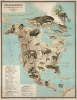
Északamerika. Jellemzöbb Gerinces Állatai.
Zoological wall map reflecting a pioneering Hungarian female educator's innovative approach to teaching through curiosity and cartography.
- Digital Map Information
- Suitable for large format printing
- Full resolution TIFF file
- ICC color profile embedded
- Delivered instantly via download link
Zoological wall map reflecting a pioneering Hungarian female educator's innovative approach to teaching through curiosity and cartography.
This spectacular 1927-28 Hungarian pictorial zoological wall map of North America was conceived by pioneering female educator Baloghné Hajós Terézia and illustrated by Bálint János. Part of an extraordinary series depicting the characteristic wildlife of the world's continents, the map represents an innovative approach to teaching natural history through cartography. Bold, colorful, and visually arresting, the series prioritizes curiosity and discovery over strict zoological precision. Conceived as powerful pedagogical tools, these maps transform the classroom wall into a window on the natural world, inviting students to explore, question, and investigate.A Closer Look
The focus is emphatically zoological, with 31 dramatically illustrated American vertebrates dominating the continent. Political geography largely recedes before the animal world: national and regional boundaries are ignored, though a handful of major cities, mountains, rivers, and other geographical features provide orientation. The animals themselves become the geography, transforming North America into a panorama of its characteristic fauna.Among the most impressive is a great bowhead whale (No. 5, Balaena mysticetus), also historically known as the Greenland right whale, Arctic whale, or polar whale, which commands the northern waters. An enormous alligator sprawls across Florida and the American South, while a formidable grizzly bear occupies the Rocky Mountains. Elsewhere, creatures large and small populate the continent and surrounding waters, creating an almost encyclopedic procession of North American wildlife.
Scientific precision yields to visual impact. An electric eel, for example, appears in the Caribbean, a misleading placement since electric eels are freshwater fishes native to northern South America and do not inhabit the Caribbean. Such liberties reflect the map's purpose. Terézia and János were not attempting to provide a precise zoological distribution, but rather to introduce students to the remarkable diversity of animal life through images powerful enough to command attention from across a classroom.
This tension between scientific precision and visual imagination is central to the map's pedagogical success. The oversized animals, simplified geography, and occasional zoological imprecision encourage questions: What is that animal? Where does it actually live? Why does it live there? Rather than supplying every answer, the map stimulates curiosity and provokes questions. Terézia understood that education begins not merely with transmitting facts, but with inspiring the desire to know.
Baloghné Hajós Terézia: A Pioneering Female Educator
Baloghné Hajós Terézia was a Hungarian biologist, educator, and author whose work helped make the natural sciences accessible to a broader audience. Her educational activities extended beyond conventional classroom instruction to include natural history publications, children's literature, and popular science communication. Her ambitious zoological map series represents a compelling expression of her commitment to visual education, combining scientific knowledge with the illustrative talents of Bálint János.Her achievement is significant in the context of women's changing role in Hungarian intellectual and professional life during the Interwar Period (1918 - 1939). Although teaching had long provided women with opportunities for professional employment, the early 20th century witnessed an expansion of their participation in higher education, scientific scholarship, and educational publishing. This progress was neither universal nor uninterrupted, and women still faced significant institutional and social barriers. Nevertheless, the period created new opportunities for women to contribute to scientific and educational discourse, a transformation exemplified by Terézia's ambitious cartographic undertaking.
Terézia's contribution was not simply to help disseminate established scientific knowledge but to help determine how that knowledge could be communicated. Her collaboration with János produced an original visual language that made zoology accessible, memorable, and exciting. The resulting maps stand as both innovative pedagogical achievements and tangible expressions of women's expanding influence on education during the interwar years.
Állat-térképek Series
This North America map belongs to a series of six zoological wall maps conceived by Baloghné Hajós Terézia and illustrated by Bálint János. Work began in 1926, and the series received Ministry of Religion and Public Education approval number 73.425/1927, confirming official approval by 1927. Together, the maps encompass Hungary and the major continents, with South America and Australia combined on a single sheet. The series was conceived as a pedagogical project, using large, memorable images of characteristic vertebrates positioned near the centers of their geographical ranges. The six maps in the Állat-térképek series are:- Hungary: Magyarország jellemzőbb gerinces állatai - 1:900,000; 85 x 116 cm; 64 animals.
- Europe: Európa jellemzőbb gerinces állatai - 1:5,000,000; 85 x 116 cm; 50 animals.
- Asia: Ázsia jellemzőbb gerinces állatai - 1:13,000,000; 87 x 102 cm; 41 animals.
- Africa: Afrika jellemzőbb gerinces állatai - 1:11,000,000; 87 x 97 cm; 33 animals.
- North America: ÉszakAmerika jellemzőbb gerinces állatai - 1:10,000,000; 84 x 107 cm; 31 animals.
- South America and Australia: Dél-Amerika és Ausztrália jellemzőbb gerinces állatai - 1:10,000,000; 87 x 105 cm; 45 animals across the two maps on a single sheet.
In 1928, Terézia issued the related Állatföldrajzi atlasz (Zoogeographical Atlas), considered the first Hungarian zoogeographical atlas. Its six maps corresponded to the subjects represented in the wall-map series, though on a much smaller scale. The relationship between the atlas and the wall maps underscores the ambitious scope of Terézia's project, which translated the same zoological and geographical program into formats suitable for both individual study and classroom instruction.
From a design perspective, the series is remarkable. Rather than placing small zoological symbols on conventional maps, as other publishers did, Terézia and János let enormous, vividly rendered animals overwhelm the underlying cartography. Whales fill oceans, elephants and great cats stride across continents, and other creatures loom over mountains, rivers, and political geography. The result is neither a conventional zoological distribution map nor simply an illustrated map, but a distinctive synthesis of cartography, natural history, and visual pedagogy.
We are unaware of another contemporary cartographic series that similarly approaches zoological geography. The scale and drama of the animals make the maps immediately arresting, but their visual extravagance powerfully supports their pedagogical purpose. Terézia understood that a classroom wall map first had to capture a student's attention before it could communicate information. Scientific precision was therefore sometimes subordinated to recognition, memory, and wonder - qualities intended to stimulate questions and encourage deeper investigation of the natural world.
Publication History and Census
Baloghné Hajós Terézia designed the series, and Bálint János illustrated it. The Magyar Királyi Állami Térképészeti Intézet (Royal Hungarian State Cartographic Institute) produced the maps, and the bookselling and publishing firm founded by Kókai Lajos published them in 1927 or 1928. By then, the founder's son, Kókai Rezső, directed the firm. The series was advertised in Hungary until at least 1930.The series is scarce both individually and as a set. We have handled examples of the Asia, Africa, and (as here) North America maps, but have thus far been unable to locate examples of the Europe, Hungary, or combined South America-Australia sheets. Some maps are held separately by Hungarian institutions, but we are aware of no surviving full set and assembling one would be a worthwhile challenge for the motivated collector.
Cartographers
Baloghné Hajós Terézia (July 25, 1881 - 19xx) was a Hungarian biologist, educator, writer, and thematic cartographer active in Budapest during the first half of the 20th century. Born Terézia Schiff in Veszprém, she adopted the surname Hajós in 1908, the same year she received her teaching diploma in Budapest. She taught in Budapest's civic schools and was especially active in popularizing the natural sciences for young audiences. Alongside pedagogical and scientific articles, she wrote children’s literature and popular works on zoology and natural history. Hajós is of particular cartographic interest for her pioneering Állat-térképek (Animal Maps) and Állatföldrajzi atlasz (Zoogeographical Atlas), published in Budapest by the Hungarian Royal State Cartographic Institute (Magyar Királyi Állami Térképészet) in 1928. Hajós also collaborated on school textbooks on zoology, botany, and health. They published numerous works of natural-history and juvenile literature, including Harc az életért (1928), Az állatok beszélnek (1936), and A tornyos villa lakói. Her work consistently sought to make biological knowledge accessible to younger readers, placing her animal maps within a broader career devoted to innovative popular science and natural-history education. Further Details...
János Bálint (July 7, 1885 - c. 1940) was a Hungarian sculptor, graphic artist, and illustrator active in Budapest during the early 20th century. János was born in Csíkgyimesbükk (today Ghimeș-Făget, Romania; then in historic Hungary). He studied at the Országos Magyar Királyi Mintarajziskola (1911 - 14) and produced caricatures and illustrations for Színházi Élet (1913 - 15) and Tolnai Világlapja (1930 - 31), among other publications. His other documented work includes book illustration for the Athenaeum publishing house from at least 1917, as well as scientific and educational illustration during the 1920s. In 1926, he supplied the animal drawings for Baloghné Hajós Terézia's remarkable series of zoological wall maps, published by the Magyar Királyi Állami Térképészet. In 1927, János Bálint also served as responsible editor of A Mű: Képző és Iparművészeti Folyóirat (Art: Journal of Fine and Applied Arts), a Budapest journal devoted to fine and applied arts. In 1927, he illustrated Bogdánffy and Strobel's extensively illustrated educational textbook Természettan. Further Details...
Magyar Királyi Állami Térképészet (1867 - 1952), translated 'Royal Hungarian State Cartography,' was a Hungarian government map publishing house active in the early 20th century. The organization can trace its origins to the Austro–Hungarian Compromise of 1867, which gave Hungary marginal independence with the right to establish its own civil cartography - thus issuing tourist maps, school maps, cadastral plans, etc. Austria retained jurisdiction over more detailed topographical cartography. This changed in 1918, during World War I (1914 - 1918), when Hungarian military leadership commissioned Colonel Lajos Hajts (1866 - 1933), professor of the Ludovika Military Academy, to lay the framework for a Hungarian State Cartography. This led to the formation of the Hungarian Military Mapping Group (Magyar Katonai Térképező) on February 4, 1919. This organization followed the Austrian Militärgeographisches Institut model. In 1922, the name changed to Magyar Királyi Katonai Állami Térképezet (Royal Hungarian State Mapping Institute). In 1938, the name changed again to Magyar Királyi Honvéd Térképészeti Intézet (Royal Hungarian Institute of Military Cartography). The Honvéd Térképészeti Intézet was folded into the Soviet-style Ministry of Defense in 1952. Further Details...
Condition
Very good. Map has been stabilized on archival tissue. A few minor closed tears at margins. Large discoloration upper right over Greenland.
References
Országos Pedagógiai Könyvtár és Múzeum, Falitérkép, #FT.2021.12.1.