This item has been sold, but you can get on the Waitlist to be notified if another example becomes available, or purchase a digital scan.
1941 Guenther Propaganda Map Extolling American Military Buildup
SafeguardingAmericanLiberty-guenther-1941$1,190.00

Title
Safeguarding Our American Liberty.
1941 (dated) 32 x 22 in (81.28 x 55.88 cm)
1941 (dated) 32 x 22 in (81.28 x 55.88 cm)
Description
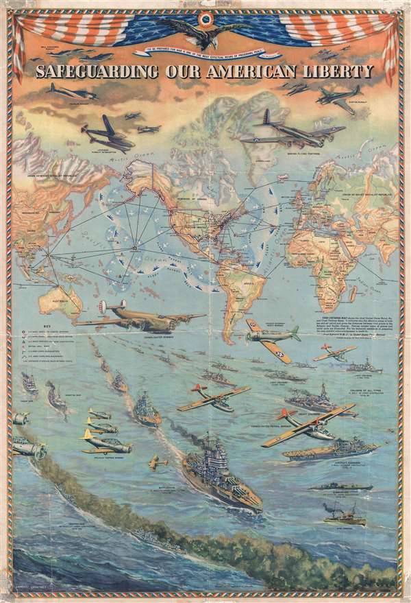
This is a 1941 Lambert Guenther propaganda broadside map of the world extolling American defensive preparedness on the brink of World War II. This broadside was issued to promote the belief that, even as war raged across the globe, the United States was capable of defending itself and projecting that defense much farther than its territorial borders. A world map centered on America serves as the broadside's main focal point and promotes the United States' defensive posture. Two 'patrol belts', the Plane Patrol Belt and, further from the coast, the Fleet Patrol Belt, are illustrated. These patrol belts allowed American forces to project farther out into both the Pacific and Atlantic Oceans to aid in the early detection of any potential attack. Cities throughout the United States, including Washington, D.C., New York, San Francisco, and New Orleans are labeled, along with countries and capital cities throughout the world. It is worth noting that Manchukuo, the puppet state created in Manchuria by Imperial Japan in 1932, is labeled. U.S. naval bases, along with those leased from Great Britain, are noted, along with U.S. Army Corps of Engineers areas of operations within the United States. British naval bases are also depicted. Distances between global cities are noted. A key along the left border explains the various notations employed on the map.
American air and sea forces are illustrated above and below the map. Above the map, the Bell P-39 Airacobra, the Lockheed P-38 Spitfire, the Curtiss P-40 Warhawk, the Douglas A-20 Havoc, and the celebrated Boeing B-17 Flying Fortress are illustrated above the map. These aircraft are accompanied by the Stars and Stripes, which frames the top of the poster, along with the quotation, 'To be prepared for war is one of the most effectual means of preserving peace,' which is attributed here to George Washington. Below the map, the Consolidated B-24 Liberator occupies center stage. The Vought-Sikorsky SB2U Vindicator, the Douglas TBD Devastator, and the Consolidated PBY Catalina accompany the Liberator above the fleet. The fleet stretches out along the bottom third of the broadside, creating a feeling of dominance and superiority. Each class of ship is labeled, and below the label the number built and the number under construction are included. The battleships are the focus, and before World War II, were believed to be the key to naval victory. Fifteen of these gigantic vessels had been built and seventeen were under construction, per the broadside. Surrounding the battleships are the heavy cruisers, light cruisers, destroyers, submarines, and aircraft carriers. Aircraft carriers had not yet showed their dominance in naval combat, and thus were not seen to be the jewels of the fleet they would become. Carriers even had their detractors in most of the world's navies, although that opinion would change. Minesweepers, troop ships, and hospital ships are also illustrated.
This broadside was created by Lambert Guenther and published Caleb Stillson Hammond and Company. It was prepared especially for Thom McAn Shoe Company.
Cartographer
Caleb Stillson Hammond (1862 - 1929) was the founder of C. S. Hammond & Company, a map making and printing firm based in Brooklyn, New York. Hammond started his career in mapmaking as the head of Rand McNally's offices in New York City, where he began working in 1894. Hammond split with Rand McNally, forming his own printing concern in Brooklyn, New York, in 1900. The firm was subsequently incorporated in 1901 and relocated to Manhattan, and then to Maplewood, New Jersey, near Hammond's family home. Hammond rose to become one of the largest cartographic publishers in the United States, second only to Rand McNally in volume. On his retirement, C. S. Hammond passed the firm to his son, who subsequently passed it to his own son, C. D. Hammond, who sold the company to Langenscheidt Publishers in 1999. The firm has since been folded into Universal Map, an affiliate of Kappa Publishing Group. This archives of the Hammond World Atlas Corporation, an invaluable resource, where donated to the Library of Congress in 2002. More by this mapmaker...
Condition
Good. Backed on archival tissue for stability. Wear along original fold lines. Residue at corners. Blank on verso.
References
Curtis, P. and J. Pedersen, War Map: Pictorial Conflict Maps 1900 - 1950 p. 134-35. Rumsey 12033.000. OCLC 12620278.