1877 Largeau Map of the Sahara Desert, Eastern Algeria
Sahara-largeau-1877$500.00

Title
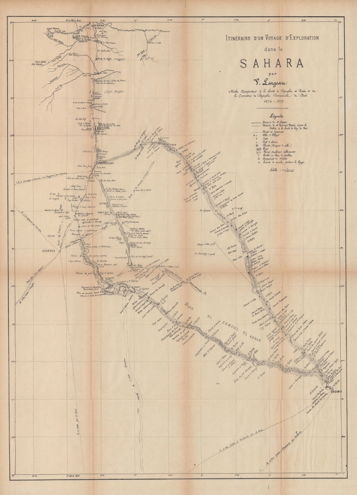
Itinéraire d'un Voyage d'Exploration dans le Sahara.
1877 (dated) 26.5 x 19.5 in (67.31 x 49.53 cm) 1 : 1000000
1877 (dated) 26.5 x 19.5 in (67.31 x 49.53 cm) 1 : 1000000
Description
An engrossing map of a portion of the Sahara Desert in eastern Algeria produced by Victor Largeau for his 1877 book Le Sahara: premier voyage d'exploration de V. Largeau. Largeau was one of the first Europeans to explore this part of the Sahara and the information he gathered was important in providing some guidance to subsequent travelers who dared to venture into the desert.
Additionally, caravan routes between scattered oasis towns are marked out, along with oases, wells and water sources, tombs, nomad camps, and more. A dashed line traces the route of Charles Norbert Dourneaux-Duperré, another French explorer who was killed the previous year (1874) during his travels, a common fate for explorers of the Sahara at the time. Largeau was lucky to avoid a violent end, but cut short a subsequent trip in the region, his last, following the massacre of Paul Flatters and his companions further to the west in 1881 (their expedition left from Ouargla, seen at left here).
A Closer Look
Coverage includes an area of eastern Algeria leading towards the intersection of Algeria, Libya, and Tunisia, focusing on routes leading from Biskra at top and Ouargla at left to Ghadames (here as Rhadames) towards bottom-right. Largeau's course of travel between January and March 1875 is traced, leaving from Touggourt and heading southwards to Ghadames, and returning back to Touggourt via El Oued.Additionally, caravan routes between scattered oasis towns are marked out, along with oases, wells and water sources, tombs, nomad camps, and more. A dashed line traces the route of Charles Norbert Dourneaux-Duperré, another French explorer who was killed the previous year (1874) during his travels, a common fate for explorers of the Sahara at the time. Largeau was lucky to avoid a violent end, but cut short a subsequent trip in the region, his last, following the massacre of Paul Flatters and his companions further to the west in 1881 (their expedition left from Ouargla, seen at left here).
Largeau's First Sahara Expedition
Largeau's long title and associations were the result of his difficulty securing backing for the expedition. In addition to the organizations mentioned here, he also appealed to the Chambers of Commerce in Marseilles and Philippeville (Skikda) and the local government (département de Constantine) in order to gain enough financial support to attempt the journey. Though not the first European or even the first Frenchman to attempt a journey into the Sahara, Largeau's efforts were important for providing detailed information on the routes to Ghadames, an ancient Berber oasis town that could be a jumping off point for any further venture into the desert.Publication History and Census
This map was drawn by Largeau for his book Le Sahara: premier voyage d'exploration de V. Largeau, published by Sandoz and Fischbacher in 1877. It is not known to be held by any institution and is scarce to the market, while the entire book is more widely distributed, held by about 30 institutions (OCLC 10902755, co-mingling digital and physical examples).Cartographer
Léon Victor Largeau (June 21, 1842 - March 26, 1897) was a French explorer and colonial administrator in Africa. Beginning in French Algeria, he undertook explorations of the Sahara Desert between 1874 and 1881, when, among other endeavors, he studied potential routes for a railway across the desert. Afterwards he served as a colonial administrator in Senegal and the Congo. His son, Victor Emmanuel Largeau, became an army officer, also serving in Africa, where he began the Great War, before returning to France as a general and being killed at the Battle of Verdun. More by this mapmaker...
Source
Largeau, V., Le Sahara: premier voyage d'exploration de V. Largeau, (Paris: Sandoz and Fischbacher) 1877.
Condition
Good. Toning and creasing along fold lines, with wear at intersections.