1850 / 1860 Manuscript Map of Saigon on back of rare Shanghai Chart
SaigonShanghai-deschampe-1850$7,500.00


Title
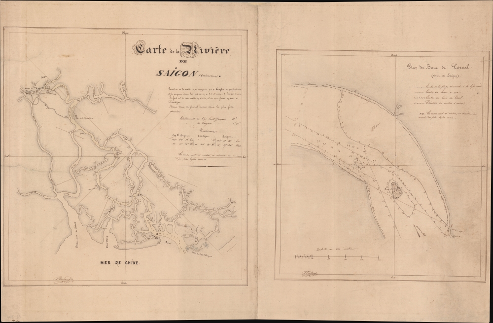
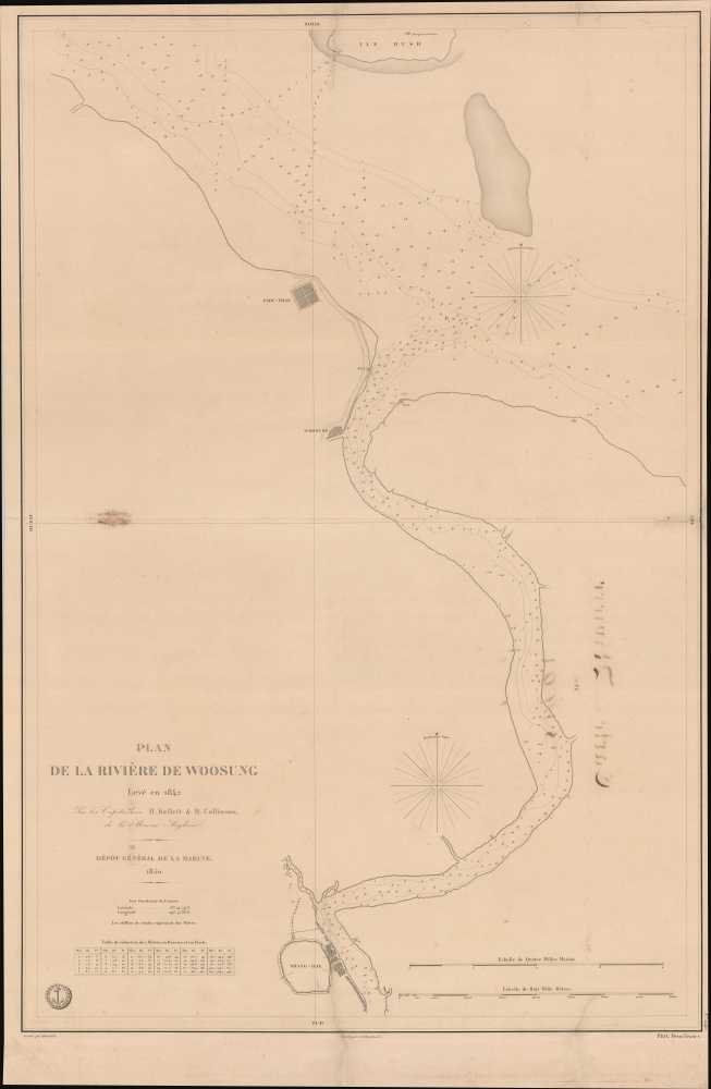
Carte de la Rivière de Saigon (Cochinchine). / Plan du Band de Corail (rivière de Saigon). / Plan de al Rivière de Woosung Levé en 1842 Par les Capitaines H. Kellet and R. Collinson, de la Marine Anglaise.
1850 (dated) 24.5 x 37.5 in (62.23 x 95.25 cm)
1850 (dated) 24.5 x 37.5 in (62.23 x 95.25 cm)
Description
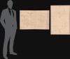
This is a remarkable set of back-to-back maps - both are significant in different ways. The most interesting is a finely-executed c. 1860 manuscript chart detailing river approaches to Saigon (Ho Chi Min City). On the verso (or recto, depending) is an 1850 printed nautical chart of the approaches to Shanghai based on the cartography of the First Opium War (1839 - 1842). Both maps are significant, with the manuscript taking primacy as, in all likelihood, it is the first modern hydrographic survey of the Song Sai Gon Estuary.
The manuscript is undated, but it almost certainly hails from the French seizure of Saigon around 1859-60. We have identified a similar printed nautical chart published around 1863 by Léo de Lespès, which is based upon this manuscript - with several updates. The coverage is identical, although the later printed chart has been revised more detail than is present here. Both charts feature a larger scale map of the dangerous 'Banc de Corail'.
Both manuscript maps (Saigon and Banc de Corail) bear the signature of A. Deschamps. We have unfortunately been unable to learn more of this elusive cartographer.
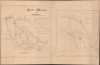
Manuscript Map of Saigon
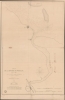
This spectacular manuscript map details the complex network of waterways between the China Sea and Saigon. It is likely the earliest hydrographic survey of these waters. It emerged from French efforts to seize and develop Saigon as a major port in the early 1860s. Soundings in meters elucidate the most important channels, with further identification of fortifications, villages, notable trees, and more. It highlights a large coral reef, Banc de Corail, at center, with the same treated with great care in a large detail map at right. This coral bank, situated centrally on one of the main navigable channels to and from Saigon, was a significant danger coming to and from the city. It remains a threat to navigation to this day.The manuscript is undated, but it almost certainly hails from the French seizure of Saigon around 1859-60. We have identified a similar printed nautical chart published around 1863 by Léo de Lespès, which is based upon this manuscript - with several updates. The coverage is identical, although the later printed chart has been revised more detail than is present here. Both charts feature a larger scale map of the dangerous 'Banc de Corail'.
Both manuscript maps (Saigon and Banc de Corail) bear the signature of A. Deschamps. We have unfortunately been unable to learn more of this elusive cartographer.
The Map of Shanghai
The printed Shanghai map / nautical chart is itself quite rare. Although published by the French Dépòt Général de la Marine in 1850, it represents British surveys made during Shanghai's occupation in the First Opium War (1839 - 1842) by commanders Henry Kellett (1806 - 1875) and Richard Collinson (1811 - 1883).A Closer Look at Shanghai
On a scale of 1:28610, coverage embraces from the confluence of the Yangtze and Huangpu (Woosong) Rivers, south along the Huangpu as far as the old city of Shanghai (Shang-Hae). Soundings along the Huangpu are numerous, but there is otherwise very little inland detail. Around the somewhat circular walled city, the map notes some port development, as well as development along nearby roads. However, the map generally predates the rapid development of Shanghai during the Treaty Port Era. Further north, the map recognizes several forts protecting the river, including the walled city of Paou-Shan and the fishing port of Woosung.Publication History and Census
We are aware of no other examples of either the manuscript maps of Saigon, or the printed nautical chart. We have noted that the original manuscript draught for the Shanghai map survives at the Bibliothèque nationale de France but note no other known printed examples. Conversely, we are aware of a related printed map of the Song Sai Gon Estuary, but as a manuscript piece, it is unique.CartographerS
Dépôt des Cartes et Plans de la Marine (fl. 1720 - present), often called the Dépôt de Marine, was a French hydrographic mapping organization founded in 1720 under Charles-Hercule of Albert de Luynes (1674 - 1734). Much like the U.S. Coast Survey, the British Admiralty, and the Spanish Deposito Hydrografico, the Dépôt was initiated as a storehouse and distribution center of existing nautical and marine charts. Eventually the Dépôt initiated its own mapping activities in an attempt to improve and expand upon existing material. Some of the more prominent cartographers and hydrographers associated with the of Dépôt des Cartes were, Philippe Buache, Jacques-Nicholas Bellin, Giovanni Rizzi-Zannoni, Rigobert Bonne, and Jean Nicolas Buache. More by this mapmaker...
Richard Collinson (November 7, 1811 – September 13, 1883) was an English naval officer, marine surveyor, and Arctic explorer. He was born in Gateshead, Tyne and Wear, England, then part of Durham. He joined the Royal Navy in 1823, at age twelve, and rose in the ranks, becoming a lieutenant in 1835, commander in 1841, and captain in 1842. Collinson was a highly capable captain. He participated with distinction in the First Opium War (1839 - 1842). After the war, along with Commander Henry Kellett, he completed a series of pioneering surveys of the China coast from the Yangtze River to Hong Kong. These he completed between 1842 and 1846 while serving as commander of the HMS Plover. In 1850, he was sent north in command of the HMS Enterprise to search for survivors of the Sir John Franklin expedition. Although he came quite close, he never found Franklin's lost men and returned to England without success. Nonetheless, he was honored by the Royal Geographical Society for his surveys in the Arctic and proof that it was navigable from the Behring Strait to King William's Land. Collinson was Knighted in 1875, the same year in which he retired from active duty with the rand of Admiral. Collinson died in September of 1883. Learn More...
Henry Kellett (November 2, 1806 - March 1, 1875) was a Irish / British naval officer and hydrographer active in the mid-19th century. Kellett was born in Tipperary County, Ireland. He joined the Royal Navy in 1822. He afterwards spent three years in the West Indies. He was transferred to survey duty in Africa under William Fitzwilliam Owen (1774 - 1867). Just before the First Opium War (1839 - 1842) he was reassigned to China as the second-in-command of HMS Sulphur under Edward Belcher (1799 - 1877), famous for producing the first survey of Hong Kong Island. During the Opium War he was assigned his own ship, the HMS Starling and promoted first to commander (1841), then to post-captain (1842). In 1845 Kellett was appointed captain of the survey ship HMS Herald tasked to map the Americas from Guayaquil to Vancouver, including the Galápagos. In 1848, he joined the search for Sir John Franklin (1786 - 1847). During this voyage he sailed through the Bering Strait across the Chukchi Sea and discovered Herald Island. Later, Kellett became Senior Officer in the West Indies in 1855 and superintended Jamaica Dockyard. He served as Admiral Superintendent of the Malta Dockyard in 1864 and Commander-in-Chief, China Station in 1869. He retired in 1871 at the rank of Vice Admiral. Learn More...
Condition
Good. Partial centerfold split. Some ink burn through. Even toning. Edge wear.
References
cf. (Shanghai) Bibliothèque nationale de France, département Cartes et plans, GE SH 19 PF 179 DIV 18 P 21. cf. (Saigon) Bibliothèque nationale de France, département Cartes et plans, GE B-902.