This item has been sold, but you can get on the Waitlist to be notified if another example becomes available, or purchase a digital scan.
1950 Somerville Map of the World and Sailing Ship Routes
SailingShipRoutes-somverville-1950$150.00

Title
The World Sailing Ship Routes.
1950 (dated) 25.5 x 49.75 in (64.77 x 126.365 cm) 1 : 30800000
1950 (dated) 25.5 x 49.75 in (64.77 x 126.365 cm) 1 : 30800000
Description
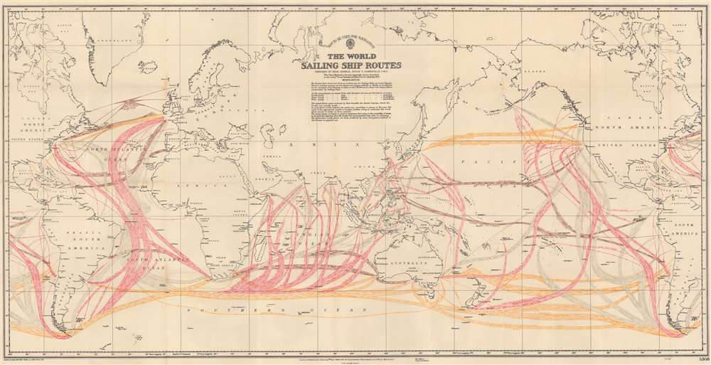
This is a 1950 Boyle T. Somerville map of world sailing routes. Somerville uses color to identify the direction of the illustrated routes with north-going routes tinted pink, south-going routes tinted gray, east-going routes tinted yellow, and west-going routes tinted brown. Arrows within the routes reinforce the direction of the route and the months when each route is used appear in darker shades of each tint. No political boundaries are illustrated, and only a few nations are identified. Important port cities are labeled worldwide, including New York, London, Montevideo, Buenos Aires, Rio de Janeiro, Cape Town, Mumbai (Bombay), Shanghai, and Hong Kong.
Publication History and Census
This map was compiled by Boyle Somerville for publication in his work for the Admiralty entitled Ocean Passages for the World first published in 1923. The present example of the map accompanied the second edition of the book published in 1950. The 1950 edition of the book is well represented in institutional collections, but the separate map is not cataloged in OCLC.CartographerS
Henry Boyle Townshend Somerville (September 7, 1863 - March 24, 1936) was an Irish Royal Navy officer, hydrogapher, and author. Born in Castletownshend County, Cork, Somerville entered the Royal Navy in 1877 as a cadet. In 1880 he was sent to South America and in 1882 served in the Anglo-Egyptian War. He spent the following four years on the China Station. He chose to be trained as a Hydrographic Surveyor because he saw good promotion prospects and believed it offered a freer existence when compared with much of Navy life. Between 1890 and 1908, Somerville took part in numerous survey expeditions to the South Pacific and Indian Oceans and then surveyed British coastal waters from 1908 until 1914. He was promoted to commander on December 31, 1901, and captain in 1912. He commanded four different vessels between 1914 and 1916 in the North Atlantic Patrol during World War I around Madeira, the Canary Islands, the Azores, and the Cape Verde Islands. At one point he spent 385 consecutive nights at sea since there were no safe harbors in these island groups. He was transferred to Halifax, Nova Scotia, in 1917 and commanded the HMS Devonshire in support of Atlantic convoys. In late summer 1917, Somerville was appointed 'officer in charge of the Naval Section within the Secret Service Bureau' (better known as the British Secret Intelligence Service). He retired on August 2, 1919 and returned to Castletownshend and the family home. During his retirement Somerville continued to work for the Admiralty, working on the Tidal Committee and in the Hydrographic Office. He also published several books, including Ocean Passages in 1923 and continued to work in archaeology and ethnography, two disciplines he had worked in during his time in the Navy. Somerville was murdered in his home on March 24, 1936, by the IRA (Irish Republican Army). A note left by the assassin stated that 'This British agent has recruited 52 boys to the British Army in the past few months'. Unfortunately, the shooting was likely a case of mistaken identity, as his brother who served in the Army lived close by was much more prominent and the more likely target. In his later years, IRA leader Tom Barry stated that the shooting was a mistake and that he was supposed to be taken hostage. More by this mapmaker...
The British Admiralty Office (1795 - Present) or the United Kingdom Hydrographic Office refers to the Branch of the English government that is responsible for the command of the British Navy. In 1795 King George III created the United Kingdom Hydrographic Office, known in short as the U.K.H.O., to provide top notch nautical charts to the vast Royal Navy. Prior the founding of the Admiralty the surveying and creation of nautical charts was primarily a commercial venture wherein the cartographer himself, more of than not, actually financed the printing of his own material. The great navigator Cook himself is known to have scrambled for funds to publish his own seminal charts - the most important and advanced of the period. The system of privately funded nautical mapping and publishing left vast portions of the world uncharted and many excellent charts unpublished. King George III, responding significant loss in trade revenue related to shipwrecks and delay due to poor charts, recognized the need for an institutionalized government sponsored cartographic agency - the Admiralty. The first head of the Admiralty, a position known as Hydrographer, was the important cartographer Alexander Dalrymple. Dalrymple started by organizing and cataloging obtainable charts before initiating the laborious process of updating them and filling in the blanks. The first official Admiralty Chart appeared in 1800 and detailed Quiberon Bay in Brittany. By 1808 the position of Hydrographer fell to Captain Thomas Hurd. Hurd advocated the sale of Admiralty charts to the general public and, by the time he retired in 1829, had issued and published some 736 charts. Stewardship of the organization then passed to Rear Admiral Sir Francis Beaufort. It was under Beaufort's administration that the Admiralty truly developed as a "chart making" as opposed to a "chart cataloging" institution. Beaufort held his post from 1829 to 1854. In his 25 years at the Admiralty Beaufort created nearly 1500 new charts and sponsored countless surveying and scientific expeditions - including the 1831 to 1836 voyage of the H.M.S. Beagle. By 1855 the Admiralty's chart catalog listed some 1,981 charts. Learn More...
Source
Somerville, B.T. and A.F.B. Woodhouse, Ocean Passages for the World. (London: Admiralty) 1950. 2nd Edition.
Condition
Very good. Light wear along original fold lines.