This item has been sold, but you can get on the Waitlist to be notified if another example becomes available, or purchase a digital scan.
1794 Edwards and Stockdale Map of Saint Vincent
SaintVincent-stockdale-1794$125.00

Title
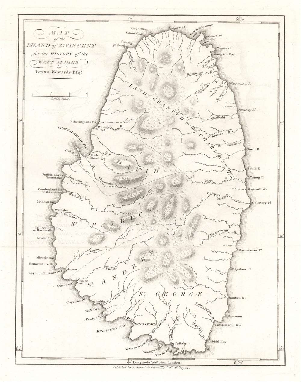
Map of the Island of St. Vincent.
1794 (dated) 10.25 x 8 in (26.035 x 20.32 cm) 1 : 126720
1794 (dated) 10.25 x 8 in (26.035 x 20.32 cm) 1 : 126720
Description
This is a 1794 Bryan Edwards and John Stockdale map of Saint Vincent. Part of the Winward Islands, Saint Vincent is the largest island in the modern-day country 'Saint Vincent and the Grenadines'. Kingstown, the island's capital, is labeled. Bays and points are marked along the coast, and the island's parishes are identified. The northernmost portion of the island is labeled 'land granted to the Charibs in 1773'. The Caribs are St. Vincent's native peoples, and they repeatedly revolted against British rule in the 18th century. Calm was only restored after a treaty was signed in 1796. Saint Vincent gained its independence in 1979 and is part of the British Commonwealth of Nations to this day.
Publication History and Census
This map was created by Bryan Edwards for inclusion in his The History Civil and Commercial of the British Colonies of the West Indies and published by John Stockdale. Five examples are cataloged in OCLC and are part of institutional collections at the University of Florida, the University of Texas at Arlington, the National Library of Scotland, the State Library of Victoria, and the Bayerische Staatsbibliothek in Munich, Germany.CartographerS
Bryan Edwards (May 21, 1743 - July 15 or 16, 1800) was a British politician and colonial administrator active in the later part of the 18th century. Born in Westbury, England, Edwards lost his father at 13 years of age. His education was subsequently taken over by his uncle, Zachary Bayly, a wealthy merchant based in Jamaica. This would turn out to have a profound influence on Edwards. When Bayly died in the 1770s, Edwards inherited his uncle's substantial wealth and quickly rose to a position of prominence in the Colonial Assembly of Jamaica. Raised in the plantation culture of Jamaica, Edwards used his wealth and influence to advocate for the continuation of the slave trade. Despite being politically misguided, Edwards was regarded with respect by both his colleagues and opponents. During his long tenure in the West Indies, Edwards wrote a number of histories and administrative studies, many of which featured important cartographic works and offered an illuminating view of the British colonies in the region. He is also known to have returned to England on several occasions where he repeatedly attempted and failed to acquire a seat in Parliament. Eventually, he was elected to represent the Cornish borough of Grampond, though the election itself may have been corrupt. Edwards was also secretary of the Association of Promoting the Discovery of the Interior Parts of Africa. In this capacity, he wrote of the first known account of the travels of Mungo Park in Africa. More by this mapmaker...
John Stockdale (March 25, 1750 - June 21, 1814) was an English book and map publisher active in London in the late 18th and early 19th centuries. Stockdale, born in Caldbeck, England, was trained by his father in the family trade of blacksmithing. Blacksmithing must not have been his cup of tea, for as soon as he was able, he left this trade in favor of a number of minor service positions, working at various times as a porter and a valet. One such position put him in the service of the bookseller John Almon. Having learnt the book trade by observing Almon, Stockdale opened his own bookshop and began publishing various historic and scientific works. Fellow publishers, perhaps reacting to his social status at birth, wrote of him, "being a man of natural parts, he soon became conspicuous in business in spite of much eccentricity of conduct and great coarseness of manners." Never quite accepted in the trade, Stockdale's fellow London publishers derogatorily referred to him as "The Bookselling Blacksmith". Nonetheless, Stockdale had a number of important works to his name, including several geographies, most notably the 1794American Geography 1794 and, with John Cary, the 1805 New British Atlas. Learn More...
Source
Edwards, Bryan, The History Civil and Commercial of the British Colonies of the West Indies, 1800.
Condition
Very good. Exhibits light offsetting.
References
OCLC 822014420.