This item has been sold, but you can get on the Waitlist to be notified if another example becomes available, or purchase a digital scan.
1857 U.S.C.S. Map of San Diego Bay, California
SanDiegoBay3-uscs-1857$325.00

Title
San Diego Bay California
1857 (dated) 27 x 20.5 in (68.58 x 52.07 cm) 1 : 40000
1857 (dated) 27 x 20.5 in (68.58 x 52.07 cm) 1 : 40000
Description
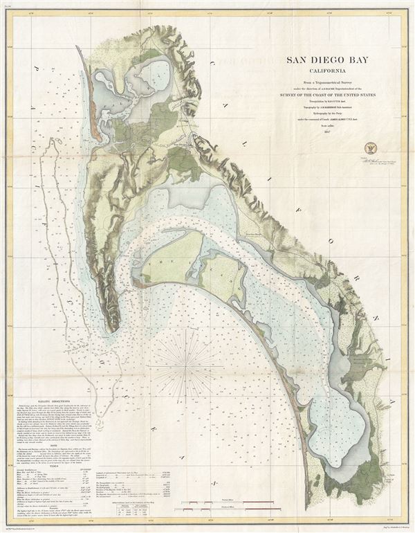
This is the most attractive map of San Diego Bay, California, to emerge from the work of the U.S. Coast Survey. Covers the Sand Diego area from False Bay and the Valley of Las Yeguas southward past Mission Valley and San Diego city to San Diego Bay and the villages of La Punta and the Valley of Ohjia. Offers superb detail both inland and at sea. Inland detail includes topographical features, rivers, roads, and villages. Villages and cities, including San Diego, La Playa, New San Diego, and others, are detailed to the level of individual buildings. Valuable information for the mariner includes innumerable depth soundings, breakwaters, and details on the Kelp Beds of the coast of Point Lonia. The lower left quadrant features detailed sailing instructions as well as notes on the tides and a history of the chart.
This cart was prepared under the supervision of A. D. Bache for inclusion in the 1857 edition of the Report of the Superintendent of the United States Coast Survey. The triangulation for this chart was accomplished by R. D. Cutts, the topography by A. M. Harrison, and the hydrography by a party under the command of James Alden.
This cart was prepared under the supervision of A. D. Bache for inclusion in the 1857 edition of the Report of the Superintendent of the United States Coast Survey. The triangulation for this chart was accomplished by R. D. Cutts, the topography by A. M. Harrison, and the hydrography by a party under the command of James Alden.
CartographerS
The Office of the Coast Survey (1807 - present) founded in 1807 by President Thomas Jefferson and Secretary of Commerce Albert Gallatin, is the oldest scientific organization in the U.S. Federal Government. Jefferson created the "Survey of the Coast," as it was then called, in response to a need for accurate navigational charts of the new nation's coasts and harbors. The spirit of the Coast Survey was defined by its first two superintendents. The first superintendent of the Coast Survey was Swiss immigrant and West Point mathematics professor Ferdinand Hassler. Under the direction of Hassler, from 1816 to 1843, the ideological and scientific foundations for the Coast Survey were established. These included using the most advanced techniques and most sophisticated equipment as well as an unstinting attention to detail. Hassler devised a labor intensive triangulation system whereby the entire coast was divided into a series of enormous triangles. These were in turn subdivided into smaller triangulation units that were then individually surveyed. Employing this exacting technique on such a massive scale had never before been attempted. Consequently, Hassler and the Coast Survey under him developed a reputation for uncompromising dedication to the principles of accuracy and excellence. Unfortunately, despite being a masterful surveyor, Hassler was abrasive and politically unpopular, twice losing congressional funding for the Coast Survey. Nonetheless, Hassler led the Coast Survey until his death in 1843, at which time Alexander Dallas Bache, a great-grandson of Benjamin Franklin, took the helm. Bache was fully dedicated to the principles established by Hassler, but proved more politically astute and successfully lobbied Congress to liberally fund the endeavor. Under the leadership of A. D. Bache, the Coast Survey completed its most important work. Moreover, during his long tenure with the Coast Survey, from 1843 to 1865, Bache was a steadfast advocate of American science and navigation and in fact founded the American Academy of Sciences. Bache was succeeded by Benjamin Pierce who ran the Survey from 1867 to 1874. Pierce was in turn succeeded by Carlile Pollock Patterson who was Superintendent from 1874 to 1881. In 1878, under Patterson's superintendence, the U.S. Coast Survey was reorganized as the U.S. Coast and Geodetic Survey (C & GS) to accommodate topographic as well as nautical surveys. Today the Coast Survey is part of the National Oceanic and Atmospheric Administration or NOAA as the National Geodetic Survey. More by this mapmaker...
James Alden, Jr. (March 31, 1810 – February 6, 1877) was a Rear Admiral in the United States Navy. Born in Portland Maine, Alden became a midshipman on April 1, 1829 and was promoted to a passed midshipman on June 14, 1834. After serving in the Mediterranean and in Boston, Alden was assigned to the U.S. Exploring Expedition under Charles Wilkes where he served on the USS Porpoise. Alden never quite got along with Wilkes, the expedition's leader. Following the U.S. Ex. Ex.'s successful return Alden was promoted to Lieutenant (February 25, 1841) and assigned to the USS Constitution. He later served in the Mexican American War and participated in the captures of Veracruz, Tuxpan and Tabasco. In 1849, after the close of the war, Alden took a position with the United States Coast Survey. From 1849 to 1851 he commanded surveys along the Eastern Seaboard. Later he was reassigned to the Pacific and was responsible for most significant Coast Survey work on the west coast. At the outbreak of the American Civil War he participated in a number of naval battles and sieges. Late in his career he was prompted to Commodore, the highest rand then achievable in the U.S. Navy. He died in San Francisco on February 6, 1877. Learn More...
Source
Bache, A. D., Report of the Superintendent of the United States Coast Survey, (Washington) 1857.
Condition
Very good condition. Minor toning on original fold lines. Backed with archival tissue for stability.