1914 Southern Pacific Railroad City Map or Plan of San Francisco, California
SanFrancisco2-southernpacific-1914$850.00

Title
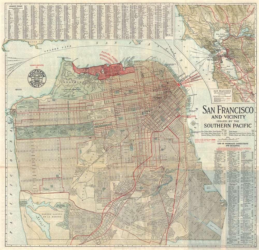
San Francisco and Vicinity Issued by the Southern Pacific.
1914 (dated) 26 x 27 in (66.04 x 68.58 cm) 1 : 30000
1914 (dated) 26 x 27 in (66.04 x 68.58 cm) 1 : 30000
Description
An attractive first edition 1914 city map or plan of San Francisco, California, issued in by the Southern Pacific Railroad. The map covers the northern part of San Francisco Peninsula from Bellevue Street and Lake Merced to San Francisco Bay. The routes of the Southern Pacific Railroad are highlighted in red, emphasizing their utility in accessing the Panama-Pacific International Exposition. This, however, may not have been the case, as there is another depot near the exposition grounds for ferries, operated by a competitor, that offers direct access to the fair. It is also important to note that the Exposition did not begin until February 1915, and this map was printed in 1914. Thus, it was created while the Panama-Pacific International Exposition was still in the planning phases. Geographically, the map offers impressive detail, all streets and numerous parks and public buildings are identified, even the individual links in the San Francisco Gold and Country Club are noted. Golden Gate Park and the Presidio Military Reservation are particularly well rendered. At the top of the map, the lands reserved for the Panama-Pacific International Exposition are marked and highlighted in red.
Panama-Pacific International Exposition
The Panama-Pacific International Exposition (PPIE) was a world's fair held in San Francisco between February 20 and December 4, 1915. Ostensibly, the fair was intended to celebrate the completion of the Panama Canal, but it was also an opportunity for San Francisco to showcase its recovery from the devastating 1906 earthquake. The fair was constructed on a 635-acre site (shaded in red) along the northern shore now known as the Marina District. Of course, at this time the Golden Gate and Oakland Bay Bridges have yet to be built. Street and building indexes surround the map proper. A more general map of the entire San Francisco Bay region appears in the upper right corner.Publication History and Census
This map was issued by the Southern Pacific Railroad, which contracted the Matthews-Northrup Works publishing firm of Buffalo to prepare and print the map. A second edition was issued in 1915. We note a single example cataloged in OCLC which is part of the David Rumsey Map Collection at Stanford University.Cartographer
Matthews-Northrup Works (fl. c. 1895 - 1930) were a Buffalo, New York based, in their own words, "writing, designing, engraving, printing, [and] binding" firm. The firm was founded by James Newson Matthews (November 21, 1828 - December 20, 1888) as the J. N. Matthews Company. William Phelps Northrup (April 2, 1850 - February 2, 1929) later joined the company as an apprentice and then partner, at which point the firm was reincorporated as the Matthews-Northrup Works. The Matthews-Northrup Works rose to prominence as publishers and printers of railroad maps, with dozens to their credit. When James died, his shares were inhered by George Edward Matthews (1855 - 1910), who ran the business until his death in 1910. Also in 1910, they famously redesigned the cover of National Geographic Magazine. Despite some six previous cover changes in just 21 years, the Matthews-Northrup layout proved so popular that it was used for nearly 50 years. The firm can also take credit for the Winchell typeface, designed in 1903 under E. E. Winchell's tenure as art director. Curiously, the partners of Matthews-Northrup maintained an unusual affectation in which only the officers of the company could wear beards or mustaches. In this same spirit, the firm also had its own private social club, the Fellowcraft Club, where the all-male employees could relax, play pool, drink and dine. Matthews-Northrup maintained offices on Washington Street, Buffalo, where they were based, as well as Madison Square, New York City, Garden Tower, Boston, and the Citizens Building in Cleveland. More by this mapmaker...
Condition
Very good. Verso repairs of fold separations. Text on verso.
References
Rumsey 5466.001. OCLC 953571502.