This item has been sold, but you can get on the Waitlist to be notified if another example becomes available, or purchase a digital scan.
1859 U.S. Coast Survey Chart or Map of San Francisco, California
SanFrancisco2-uscs-1859$250.00

Title
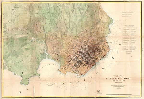
City of San Francisco and its Vicinity California.
1859 (dated) 24 x 35 in (60.96 x 88.9 cm) 1 : 10000
1859 (dated) 24 x 35 in (60.96 x 88.9 cm) 1 : 10000
Description
A rare coastal chart of San Francisco by the U. S. Coast Survey, 1859. Oriented to the west, this map depicts the immediate city of San Francisco and surrounding areas as far as the Mission de Dolores and Rancho San Miguel. The chart was issued about ten years following the population explosion brought on by the 1849 gold Rush. Depicts the city extending only about eleven city blocks from the waterfront. Labels piers, wharfs, parks and roads as well as indicating important individual buildings such as the City Hall, the Post Office, hospitals, and churches. The Bay features detailed depth soundings. Text on public buildings, reservoirs, sailing notes, shoals, and tidal notations are included on the top left and lower right hand corners of the map.
The work of the coast survey around the city of San Francisco was completed in 1852 and first known U.S. C. S. plan of the city and its immediate vicinity was published in the same year. Rumsey suggests that the actual city plan was taken from an earlier map produced Cook and Le Count, and Vogdes suggests that the interior topography is drawn from the eddy's official map of San Francisco. This first Coast Survey Chart of San Francisco was oriented to the north and covered a considerably small area than the map offered here. The above chart was issued in 1857 to replace the 1853 chart and account for the rapid urbanization of the San Francisco vicinity. Although much of the actual topography is based on the original 1853 map, there are a number of important updates and expansions, especially in the extreme eastern and southern quadrants. The notation of the Union Race Course, the Pioneer Race Course, the Road to San Jose, and the Rancho de San Miguel are but a few such additions. Furthermore, this map also features the addition of a 'Table of References' to the right of the main map. This numbered table identifies a number of important buildings throughout the city including churches, theaters, hotels, fire houses, hospitals and government buildings.
The trigonometrical survey for this map was prepared by R. D. Cutts. The topography was accomplished by A. F. Rodgers and the hydrography by R. M Cuyler. engraved by Julius Bien. All work was produced under the supervision of A. D. Bache, one of the most influential superintendents in the history of the U.S. Coast Survey.
CartographerS
The Office of the Coast Survey (1807 - present) founded in 1807 by President Thomas Jefferson and Secretary of Commerce Albert Gallatin, is the oldest scientific organization in the U.S. Federal Government. Jefferson created the "Survey of the Coast," as it was then called, in response to a need for accurate navigational charts of the new nation's coasts and harbors. The spirit of the Coast Survey was defined by its first two superintendents. The first superintendent of the Coast Survey was Swiss immigrant and West Point mathematics professor Ferdinand Hassler. Under the direction of Hassler, from 1816 to 1843, the ideological and scientific foundations for the Coast Survey were established. These included using the most advanced techniques and most sophisticated equipment as well as an unstinting attention to detail. Hassler devised a labor intensive triangulation system whereby the entire coast was divided into a series of enormous triangles. These were in turn subdivided into smaller triangulation units that were then individually surveyed. Employing this exacting technique on such a massive scale had never before been attempted. Consequently, Hassler and the Coast Survey under him developed a reputation for uncompromising dedication to the principles of accuracy and excellence. Unfortunately, despite being a masterful surveyor, Hassler was abrasive and politically unpopular, twice losing congressional funding for the Coast Survey. Nonetheless, Hassler led the Coast Survey until his death in 1843, at which time Alexander Dallas Bache, a great-grandson of Benjamin Franklin, took the helm. Bache was fully dedicated to the principles established by Hassler, but proved more politically astute and successfully lobbied Congress to liberally fund the endeavor. Under the leadership of A. D. Bache, the Coast Survey completed its most important work. Moreover, during his long tenure with the Coast Survey, from 1843 to 1865, Bache was a steadfast advocate of American science and navigation and in fact founded the American Academy of Sciences. Bache was succeeded by Benjamin Pierce who ran the Survey from 1867 to 1874. Pierce was in turn succeeded by Carlile Pollock Patterson who was Superintendent from 1874 to 1881. In 1878, under Patterson's superintendence, the U.S. Coast Survey was reorganized as the U.S. Coast and Geodetic Survey (C & GS) to accommodate topographic as well as nautical surveys. Today the Coast Survey is part of the National Oceanic and Atmospheric Administration or NOAA as the National Geodetic Survey. More by this mapmaker...
Augustus Frederick Rodgers (January 1, 1829 - December 9, 1908) was an American military officer active in California with the United States Coast Survey. He was born in Washington D.C., the son of John Rodgers (1812 - 1882), and American Commodore who notably defended Baltimore during the War of 1812. Rodgers was appointed to the US. Coast Survey in 1847 and assigned to the task of overseeing the survey of the California coast. His Coast Survey work included mappings of California, Oregon, and Washington coasts, Alaska, the Hawaiian Island, and the Philippines. He remained active with the survey in San Francisco, California, until his death in 1908. Learn More...
Alexander Dallas Bache (July 19, 1806 - February 17, 1867) was an American physicist, scientist and surveyor. Bache is best known in cartographic circles as the Superintendent of the U.S. Coast Survey from 1843 to 1865. Born in Philadelphia, Bache, a great grandson of the statesman and inventor Benjamin Franklin, had a varied career primarily focused on education. He toured Europe on behalf of Girard College and composed an important treatise on European Education. Later he served as president of Philadelphia's Central High School and was a professor of natural history and chemistry at the University of Pennsylvania. On the death of Ferdinand Rudolph Hassler, Bache was appointed Superintendent of the United States Coast Survey. Picking up where Hassler left off Bache presided over the Survey during its most prolific period and oversaw the mapping of most of the United States coastline. To this day his name appears on countless marine pilot books and U.S. Coast Survey nautical charts. For his work he was elected Associate Fellow of the American Academy of Arts and Sciences, a Fellow of the Royal Society of Edinburgh, and a Foreign Member of the Royal Society. Following the Civil War, Bache was elected a 3rd Class Companion of the Military Order of the Loyal Legion of the United States. He died at Newport, Rhode Island and was buried in the Congressional Cemetery in Washington, DC, where he is commemorated with a monument built by American architect Henry Hobson Richardson. Learn More...
Source
Bache, A. D., Report of the Superintendent of the United States Coast Survey, (Washington) 1859.
Condition
Good. Backed on archival tissue for stability. Minor loss and toning on original fold lines - see image. Fill repair left margin.
References
Vogdes p. 254. Rumsey 1030.000. Guthorn, P. J. United States Coastal Charts 1783 - 1861, p. 194.