This item has been sold, but you can get on the Waitlist to be notified if another example becomes available, or purchase a digital scan.
1798 La Perouse Map of San Francisco Bay, California - Earliest Map!
SanFranciscoBay-perouse-1798$600.00

Title
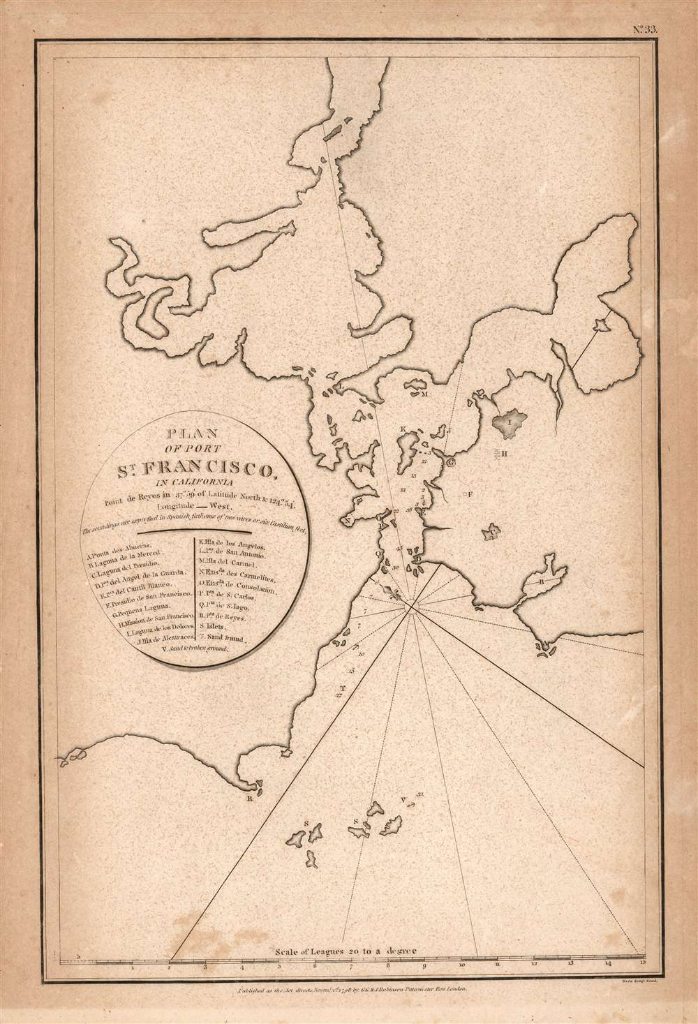
Plan of Port St. Francisco in California.
1798 (dated) 14.5 x 9.5 in (36.83 x 24.13 cm) 1 : 300000
1798 (dated) 14.5 x 9.5 in (36.83 x 24.13 cm) 1 : 300000
Description
This is the 1798 English edition of La Pérouse's seminal 1797 map of San Francisco Bay. It is the first acquirable chart of these waters to be printed in English; La Pérouse's original of the previous year is the earliest acquirable overall. The 1798 John Robinson (1752 - 1813) edition of La Pérouse's travels was one of the earliest, and best, works to bring to English audiences the discoveries of this French circumnavigator's ill-fated voyage.
The Chart
The northeast-oriented chart embraces the whole of San Francisco Bay. The peninsula at center-right shows the location of the modern urban center of modern Francisco, with the Golden Gate being the tiny entrance into the larger bay. The general form of San Pablo Bay, which leads into Suisun Bay is evident at top. The greater part of San Francisco Bay, extending towards the right side of the map is significantly truncated. The map labels eighteen points, including Alcatraz, the Presidio, Merced, the Mission of San Francisco, and other landmarks, all keyed alphanumerically via a table integrated into the title cartouche. The table also locates unnamed islets and offers navigational annotations.La Pérouse in California
Jean-François de Galaup, Comte de La Pérouse, on his great around the world voyage, passed San Francisco Bay on September 10th while coasting southernly towards Monterrey, the last stop before heading out across the Pacific to Manila and the Philippines. La Pérouse did not personally survey the Bay, and most likely obtained the data for this map from the Spanish pilot Francisco Antonio Mourelle de la Rúa (1750 - 1820) in Manila. Cartographically the map is similar to the Dalrymple Plan of 1789, which itself is based on the charts of Don Jose' de Cañizares (1776) and José Camacho y Brenes (1779, 1785).A Tragic End
La Pérouse died tragically in a shipwreck near the Solomon Islands. His journals were shipped back to Europe from Australia before the shipwreck and posthumously published in 1797, along with an accompanying atlas volume. That work was widely disseminated, for example in the 1798 English translation from which this example comes.Publication History and Census
This map was engraved by Samuel John Neele for inclusion in John Robinson's 1798 translation of La Pérouse, A voyage round the world, performed in the years 1785, 1786, 1787, and 1788.The separate chart is cataloged by OCLC in five instances. The full work is, however, well represented in institutional collections.CartographerS
Jean François de Galaup, Comte de La Pérouse (August 23, 1741 - 1788) was a French naval officer, navigator, and explorer active in the later part of the 18th century. Born into a noble family of Albi, France, La Perouse entered the navel college of Brest at just 15. At seventeen La Perouse made his first naval voyage, a supply expedition to the fort of Louisbourg in New France. He later participated in a number of naval battles, mostly against the English, and eventually rose to the rank of Commodore. In 1782 he captured the English forts Prince of Wales and York, making a name for himself back in France. Following the British defeat at the end of the American Revolutionary War, La Perouse was appointed by Louis XVI to lead an expedition of discovery circumnavigating the globe. The goal of the expedition was to complete and correct the maps of the Pacific drawn by Captain Cook. La Perouse's two frigates, the Astrolabe and the Boussole rounded Cape Horn and entered the Pacific in 1785. Crisscrossing the Pacific from Macau and Japan to Alaska, Vancouver, and the Hawaiian Islands Perouse made numerous discoveries and adding considerably to the cartographic corpus, particularly along the coast of British Columbia and around Japan. In Australia La Perouse sent his last letter back to France containing all of his maps and research. Tragically, on the return voyage La Perouse ran into a violent storm which left both of his frigates shipwrecked on the Polynesian island of Vanikoro, part of the Santa Cruz Group. Some of the survivors of the shipwrecks seem to have managed to live on the island for years afterwards. As late as 1790 the English Captain Edward Edwards saw smoke signals coming from Vanikoro but foolishly declined to investigate. Expeditions in 2005 and in 2008 identified the remains of both ships and retuned numerous artifacts from the ill-fated expedition to France. The importance of La Perouse's discoveries was, unfortunately, not seriously appreciated until many years later because, when the La Perouse maps were finally published in 1797, newer more accurate maps of the region were already in circulation. Nonetheless, La Perouse remains of the titans of Pacific exploration and he work paved the path forward for all future expeditions to the region. More by this mapmaker...
G. and J. Robinson (fl. 1785 - 1818) were Scottish book, magazine, and map publishers active in the late 18th and early 19th centuries. The firm was based at 25 Paternoster Row, London. From about 1809, it was run exclusively by G. Robinson. The firm, at various points, consisted of George Robinson (the elder) the 'King of Booksellers', George Robinson (the younger), John Robinson, and James Robinson. It was George Robinson, the younger, who continued to run the firm solo after 1909. Learn More...
Samuel John Neele (July 29, 1758 - May 13, 1824) was a prolific British map engraver active in the late 18th and early 19th centuries. Neele apprenticed as a printer and engraver with Harry Ashby from about 1781 to 1782 before establishing himself independently in 1785 at 352 Strand, London. The combination of business acumen and technical skill made Neele extremely successful with literally hundreds of maps to his credit. His vast corpus was composed of notable maps by most major English publishers of the period including, Haywood, Faden, Wallis, Stockdale, Arrowsmith, Thomson, Pinkerton, and Greenwood, among others. Neele's sons, James and Josiah Neele, also engravers, took over their fathers business around 1818, both becoming notable in their own right. Learn More...
Source
La Pérouse, Jean-Francois de Galaup, Comte de, A Voyage round the World, performed in the years 1785, 1786, 1787, and 1788, (London: G.G. and J. Robinson) 1798.
Condition
Good. Toned and freckled, with marginal mat burn.
References
OCLC 26278114. Rumsey 0414.033. Wagner, H. R., The Cartography of the Northwest Coast of America To the Year 1800, #846.