
This item below is out of stock, but another example (left) is available. To view the available item, click "Details."
Details
1903 U.S. Coast and Geodetic Survey Nautical Map of San Francisco Bay, California
1903 (dated) $950.00
1897 U.S. Coast Survey Nautical Map of San Francisco
SanFranciscoEntrance-uscs-1897$425.00

Title
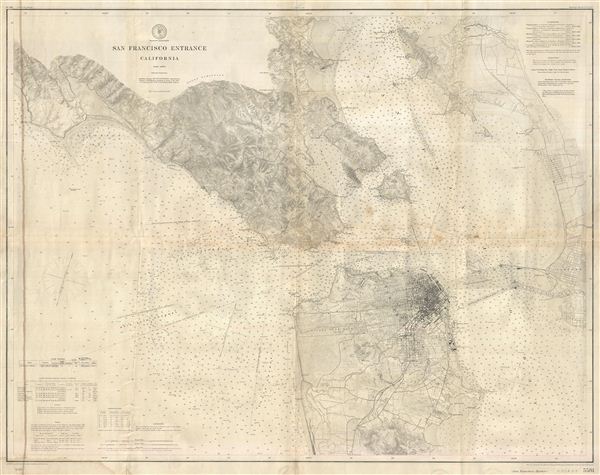
San Francisco Entrance California.
1897 (dated) 33 x 42 in (83.82 x 106.68 cm)
1897 (dated) 33 x 42 in (83.82 x 106.68 cm)
Description
This is an extraordinary highly detailed 1897 U.S. Coast and Geodetic Survey maritime map or nautical chart of the entrance to San Francisco Bay and San Francisco itself. First issued in 1884, this updated 1897 chart covers from Duxbury Point south along the Sough Channel as far as Laguna de la Merced and westward as far as Oakland and the California-Nevada Railroad. There are countless depth soundings throughout as well as notes on shoals, rocks, magnetic variation, tide, and light houses, life saving stations, and other nautical practicalities. Inland there is a wealth of topographical detail drawn from the U.S. Geodetic survey of this region. San Francisco in particular is well laid out with the grid structure and important buildings, piers, and civil works, clearly visible. Oakland, Alameda, and West Berkeley are also present but only their grid layout is rendered. This chart was used for navigation and bears a few navigational annotations in pen. Published under the direction of W. W. Duffield, Superintendent of the Coast and Geodetic Survey.
Cartographer
The Office of the Coast Survey (1807 - present) founded in 1807 by President Thomas Jefferson and Secretary of Commerce Albert Gallatin, is the oldest scientific organization in the U.S. Federal Government. Jefferson created the "Survey of the Coast," as it was then called, in response to a need for accurate navigational charts of the new nation's coasts and harbors. The spirit of the Coast Survey was defined by its first two superintendents. The first superintendent of the Coast Survey was Swiss immigrant and West Point mathematics professor Ferdinand Hassler. Under the direction of Hassler, from 1816 to 1843, the ideological and scientific foundations for the Coast Survey were established. These included using the most advanced techniques and most sophisticated equipment as well as an unstinting attention to detail. Hassler devised a labor intensive triangulation system whereby the entire coast was divided into a series of enormous triangles. These were in turn subdivided into smaller triangulation units that were then individually surveyed. Employing this exacting technique on such a massive scale had never before been attempted. Consequently, Hassler and the Coast Survey under him developed a reputation for uncompromising dedication to the principles of accuracy and excellence. Unfortunately, despite being a masterful surveyor, Hassler was abrasive and politically unpopular, twice losing congressional funding for the Coast Survey. Nonetheless, Hassler led the Coast Survey until his death in 1843, at which time Alexander Dallas Bache, a great-grandson of Benjamin Franklin, took the helm. Bache was fully dedicated to the principles established by Hassler, but proved more politically astute and successfully lobbied Congress to liberally fund the endeavor. Under the leadership of A. D. Bache, the Coast Survey completed its most important work. Moreover, during his long tenure with the Coast Survey, from 1843 to 1865, Bache was a steadfast advocate of American science and navigation and in fact founded the American Academy of Sciences. Bache was succeeded by Benjamin Pierce who ran the Survey from 1867 to 1874. Pierce was in turn succeeded by Carlile Pollock Patterson who was Superintendent from 1874 to 1881. In 1878, under Patterson's superintendence, the U.S. Coast Survey was reorganized as the U.S. Coast and Geodetic Survey (C & GS) to accommodate topographic as well as nautical surveys. Today the Coast Survey is part of the National Oceanic and Atmospheric Administration or NOAA as the National Geodetic Survey. More by this mapmaker...
Condition
Good condition. On heavy stock. Overall toning. Some verso repairs on original fold lines. Discoloration extending vertically along the length of the map, left border. Blank on verso.
References
Rusmey 3480.000 (1905 edition).