This item has been sold, but you can get on the Waitlist to be notified if another example becomes available, or purchase a digital scan.
1915 Chevalier Map of San Francisco and its Street Car Lines
SanFranciscoGuide-chevalier-1915$400.00

Title
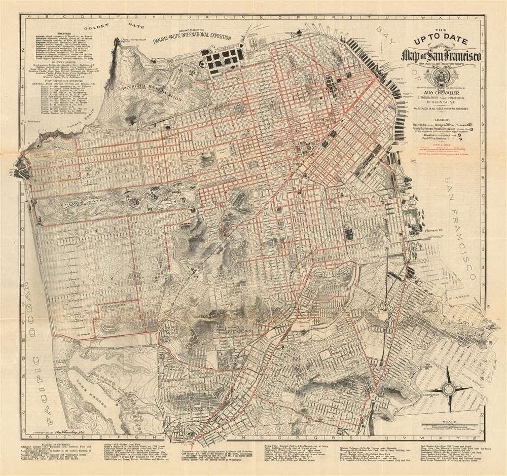
The Up To Date Map of San Francisco From Latest U.S. Gov. and Official Surveys.
1915 (dated) 19 x 20.5 in (48.26 x 52.07 cm) 1 : 27000
1915 (dated) 19 x 20.5 in (48.26 x 52.07 cm) 1 : 27000
Description
This is August Chevalier’s updated 1915 map of San Francisco. Produced in pocket-map format for the use of visitors to both the city and the then-active Panama-Pacific International Exposition, the map details the city's neighborhoods, parks, and other features needful to the visitor. Buildings of particular importance - the newly built city hall, the mint, the post office, railroad depots, Sutro Baths, Cliff House, and others - are shown pictorially. The city's distinctive topography is shown with a combination of hachure and contour lines, including elevations. The map provides lists, keyed to coordinates on the map, of Theaters, railway depots, post offices, and 'Places of Interest.'
The map also features excellent transportation information, including railroads, bridges, tunnels, and steamer piers - including prospective ones. Most distinctive to San Francisco are the “car lines” in red: the now-dwindling cable car and electric street car routes that once spanned virtually the entire city.
The map also features excellent transportation information, including railroads, bridges, tunnels, and steamer piers - including prospective ones. Most distinctive to San Francisco are the “car lines” in red: the now-dwindling cable car and electric street car routes that once spanned virtually the entire city.
The Panama-Pacific International Exposition
The Panama-Pacific International Exposition was a world's fair held in San Francisco between February 20 and December 4, 1915. Ostensibly, the fair was intended to celebrate the completion of the Panama Canal, but it was also an opportunity for San Francisco to showcase its recovery from the 1906 earthquake. The fair was constructed on a 635-acre site (shown here in detail) along the northern shore now known as the Marina District. Of course, at this time The Golden Gate and Oakland Bay Bridges have yet to be built.Publication History and Census
This map was separately published in 1915 in San Francisco in a single edition. OCLC lists copies in only the California Historical Society and the University of Wisconsin, Milwaukee. We are aware of only one other example to appear on the market.Cartographer
August Chevalier (1871 – November 29, 1934) was a French-born American lithographer living and working in San Francisco, California. He came to the United States in 1890. Nothing is known about his early life and education, but he appears to have made his name with the publication of his 1904 work 'The Commercial, Pictorial and Tourist map of San Francisco': Chevalier's wife, Josephine, came to America from France that year, so perhaps the publication of his first map provided the means for bringing her to join him. Chevalier would go on to produce half a dozen plans of his home city, of which his magnificent 1912 topographical map of San Francisco known as 'The Chevalier' is best known. In 1931 he produced a series of 'Aero-Map-Views' of various regions of California, all of which appear to be quite rare. More by this mapmaker...
Condition
Very good condition. Some wear at junctures of folds, some marginal wear. Folding map in original paper covers.