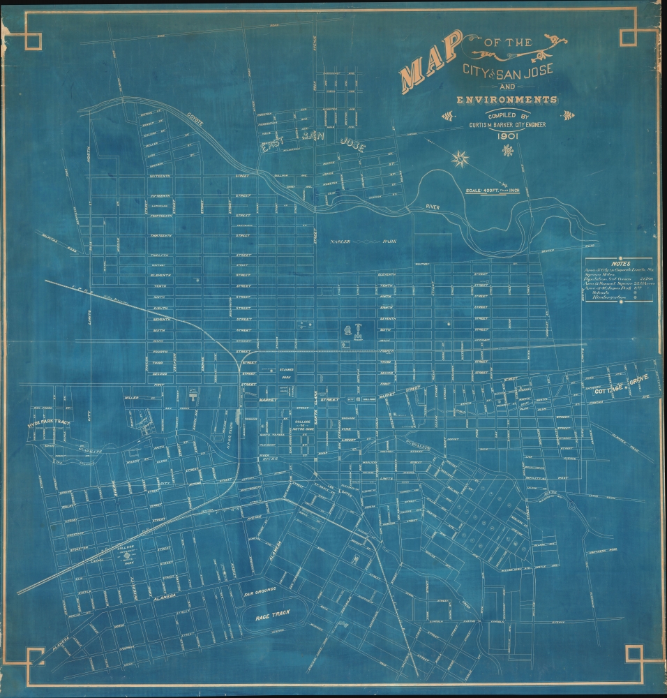
1901 Barker Cyanotype Wall Map of San Jose, California
SanJose-barker-1901$4,500.00


Title
Map of the City of San Jose and Environments.
1901 (dated) 56.5 x 54 in (143.51 x 137.16 cm) 1 : 4800
1901 (dated) 56.5 x 54 in (143.51 x 137.16 cm) 1 : 4800
Description
This is the only surviving example of Curtis M. Barker's unrecorded 1901 cyanotype or blueprint city planning wall map of San Jose, California - today's 'Capital of Silicon Valley'. It presents the city during an explosive period of expansion, as new developments and neighborhoods were being added continuously. Given the size and precision of this map, it can only be an official city planning map used by the administration for urban management.
Naglee Park at the top is not a public park but the estate of the Union Civil War General Henry Morris Naglee (1815 - 1886). Around the time of this map's production, the estate, which was sprawling and contained sumptuous gardens and vineyards, was sold to developers and subdivided for single-family home lots. Retaining the name Naglee Park, it became home to many large and architecturally significant homes (mostly built after the 1906 earthquake) designed in the Tudor and Mission Revival styles. Other developments on the periphery of the city (Hyde Park, Cottage Grove, East San Jose) also hint at its expansion at this time.
A Closer Look
The map is oriented towards the east-northeast, with the Coyote River at top and the Guadalupe River and Los Gatos Creek in the middle towards bottom. The City Limits here are far smaller than the city's eventual extent; in the following decades, the unincorporated territory to the west (bottom), including the posh Alameda neighborhood built along the old Camino Real, north, and south, would be annexed. A small legend at right explains symbols used for schools, notes the size of the city's population, and mentions the area of its largest downtown plaza and park. In addition to schools and parks, streets, planned but still undeveloped blocks (at bottom-right), hotels (including the opulent Hotel Vendome), libraries, civic buildings, rail lines and stations, a racetrack and fairgrounds at bottom, waterways, and other features are noted.Naglee Park at the top is not a public park but the estate of the Union Civil War General Henry Morris Naglee (1815 - 1886). Around the time of this map's production, the estate, which was sprawling and contained sumptuous gardens and vineyards, was sold to developers and subdivided for single-family home lots. Retaining the name Naglee Park, it became home to many large and architecturally significant homes (mostly built after the 1906 earthquake) designed in the Tudor and Mission Revival styles. Other developments on the periphery of the city (Hyde Park, Cottage Grove, East San Jose) also hint at its expansion at this time.
City of Schools
San Jose played an important role in the early history of education in California, perhaps the reason for schools being highlighted so prominently here. The State Normal School, namesake for the square (also known as Washington Sq.), was founded in San Francisco in 1857, moved to San Jose in 1871, and is now San Jose State University. The University of the Pacific - founded 1851 in Santa Clara, also moving to San Jose in 1871 - is noted at bottom-left at College Park. The university relocated to Stockton in 1923 and the Jesuit Bellarmine College Preparatory school took over the campus, but the area retains the name 'College Park.' Perhaps most notable of all is the College de Notre Dame near center, the first college chartered in California in 1851, an all-girls Catholic institution that is the basis for today's Notre Dame de Namur University located in Belmont on the San Francisco Peninsula, while another part of the institution relocated in the 1920s to a different location in downtown San Jose and became Notre Dame High School.Rail Interchange
Several railways are noted, including the Southern Pacific Railroad, the narrow-gauge South Pacific Coast Railroad running to Santa Cruz (whose depot is the basis for today's Diridon Station, a major interchange for Amtrak and Caltrain), and the Central Pacific Railroad's Niles Division, which linked nearby Fremont with Sacramento and the original Transcontinental Railroad. The city also had a nascent streetcar and interurban electric trolley system, not indicated here. The trolleys eventually ran as far south as Los Gatos and as far north as Palo Alto (by 1910, independent lines were consolidated as the Peninsular Railway, a subsidiary of the Southern Pacific).Attempts at Chinese and Japanese Exclusion
Most of the land north of Taylor St. at left belonged to James D. Phelan (1861 - 1930), a banker who was the Mayor of San Francisco when this map was produced and later a U.S. Senator from California. Having earlier been an advocate for Chinese exclusion, Phelan was a leading voice in California and nationally against Japanese immigration around this time, calling for a similar exclusion law as had been applied to Chinese immigrants. Ironically, his lands in San Jose were just adjacent to the city's Chinatown (marked here, one of several Chinatowns in San Jose, in fact), which became home to increasing numbers of Japanese immigrants at the turn of the century after Chinese immigration was restricted, leading to the area developing into San Jose's Japantown. Many of the Chinese residents of the same neighborhood (previously known as Heinlenville, after a German-American rancher who rented land to Chinese immigrants) were recent arrivals from a larger Chinatown in the city's downtown area, which was destroyed by a fire during a period of intense anti-Chinese sentiment in 1887. The fire was probably started intentionally and in any event local firefighters did nothing to douse the flames until they threatened property outside of Chinatown. After the fire, the land on which the former Chinatown sat was used to construct an opulent new City Hall (seen here, demolished in 1951) on City Hall Plaza (or Market Plaza, now the Plaza de Cesar Chavez).Cyanotype: Why so Blue?
Cyanotype is a photo-reprographic technique developed in 1842 by the British astronomer John Herschel (1792 - 1871). Sometimes called a 'sunprint', the technique employs a solution of ferric ammonium citrate and potassium ferricyanide, which is painted on white paper or cloth, and reacts when exposed to sunlight to dye the object a brilliant blue. Areas blocked from ultraviolet exposure remain undyed and white. Herschel developed the technique to reproduce his astronomical notes, but others quickly realized that any object capable of blocking light could be used to create a cyanotype image quickly and easily. By the late 19th century, the process became popular with designers, the military, architects, and engineers (blueprints), who used the cost-effective technique to quickly and exactly reproduce images in the field. Cyanotyping is limited in that only a single copy can be made at one time, so it was only practical for short-term fieldwork. Cyanotypes remain extremely reactive to light and, over time, fade or degrade, making them extremely ephemeral. The process fell out of fashion in most places by the 1920s but remains in use in some parts of the world, such as India and Nepal, to this day.Publication History and Census
This map was prepared by city engineer Curtis M. Barker in 1901 and is perhaps a unique survivor. We have been unable to locate any other examples in institutional collections or on the market.Cartographer
Curtis Mason Barker (April 12, 1861 - August 4, 1908) was an American civil engineer and surveyor. Born in Detroit Michigan, Barker was the third of three children. His father, Kirkland Charles Barker (September 8, 1819 - May 20, 1875) was a successful businessman in Detroit who owned the American Eagle Tobacco Works there. He also served as mayor of Detroit from 1865 - 1867. Curtis Barker was educated at the Michigan State University at Ann Arbor (today known as the University of Michigan), where he studied civil engineering and surveying. After graduating, firm in the belief that his job prospects were better further west, Barker moved to Colorado where he worked in the mines and as a surveyor for railroads. He moved to California in 1885, and lived and worked in Palo Also as an assistant civil engineer on the construction of Leland Stanford University. He then moved to San Jose in 1894 and opened his own surveying and civil engineering firm. Soon after moving to San Jose he was appointed city engineer and held the position until July 1, 1902. He died on August 4, 1908, when he drowned in Halfmoon Bay along the California coast while yachting. It is unclear if his death was an accident. Curiously, his father drowned while yachting on the Detroit River when Barker was a child. Barker married Zoe A. Campbell in 1883, with whom he had two daughters. More by this mapmaker...
Condition
Very good. Laid down original old linen. Some edge wear and loss. Else very clean.