This item has been sold, but you can get on the Waitlist to be notified if another example becomes available, or purchase a digital scan.
1723 De Fer Map of Hispaniola or Santo Domingo
SantoDomingo2-defer-1723$500.00

Title
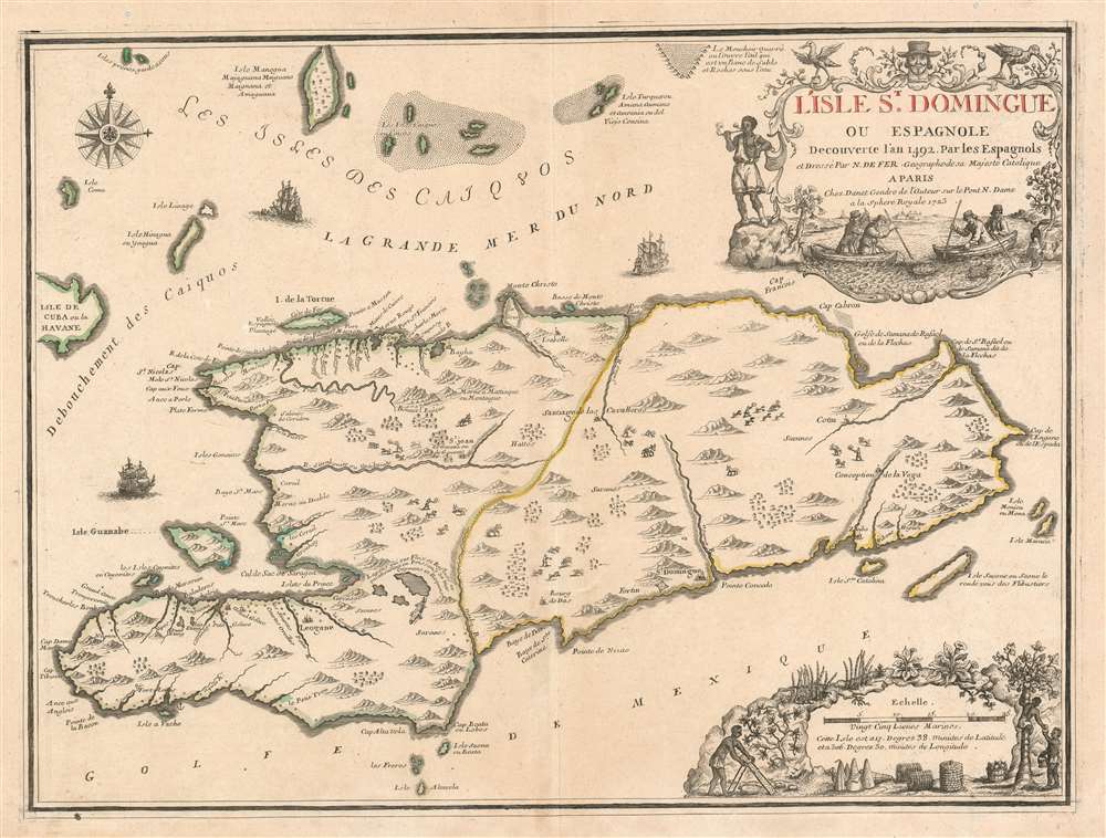
L'Isle St. Domingue ou Espagnole Decouverte l'an 1492 par les Espagnols.
1723 (dated) 17.5 x 23.5 in (44.45 x 59.69 cm) 1 : 1380000
1723 (dated) 17.5 x 23.5 in (44.45 x 59.69 cm) 1 : 1380000
Description
A stunning large format example of Nicolas De Fer and Guillaume Danet's map of the island of Santo Domingo or Hispaniola. The map coves the island in full as well as parts of adjacent Cuba and Turks and Caicos. The island is shown with colored boundaries derived from the 1697 Treaty of Ryswick dividing the island into the western French portion (modern Haiti) and the larger eastern lands of Spain (Dominican Republic). Topography is drawn in profile according to De Fer's idiosyncratic style.
Cartouches
There are two elaborate cartouches both depicting local people, flora, and fauna – no doubt intended to illustrate the wealth and abundance of the island. The upper cartouche shows two boats in shallow waters spearing sea turtles and is surmounted by a Spanish-looking gentleman with a dashing brimmed hat. The cartouche in the lower right illustrates islanders picking fruit and harvesting.Publication History and Census
This map appeared in a later edition of Nicolas De Fer's Atlas ou Recueil de Cartes Geographiques. Although the atlas was first published in 1709, this map did not appear until 1723, when, the atlas was taken over by De Fer's son-in-law, Guillaume Danet. The was both included with published versions of the atlas and sold separately, to be tipped into older editions and other composite atlases.CartographerS
Nicholas de Fer (1646 - October 25, 1720) was a French cartographer and publisher, the son of cartographer Antoine de Fer. He apprenticed with the Paris engraver Louis Spirinx, producing his first map, of the Canal du Midi, at 23. When his father died in June of 1673 he took over the family engraving business and established himself on Quai de L'Horloge, Paris, as an engraver, cartographer, and map publisher. De Fer was a prolific cartographer with over 600 maps and atlases to his credit. De Fer's work, though replete with geographical errors, earned a large following because of its considerable decorative appeal. In the late 17th century, De Fer's fame culminated in his appointment as Geographe de le Dauphin, a position that offered him unprecedented access to the most up to date cartographic information. This was a partner position to another simultaneously held by the more scientific geographer Guillaume De L'Isle, Premier Geograph de Roi. Despite very different cartographic approaches, De L'Isle and De Fer seem to have stepped carefully around one another and were rarely publicly at odds. Upon his death of old age in 1720, Nicolas was succeeded by two of his sons-in-law, who also happened to be brothers, Guillaume Danet (who had married his daughter Marguerite-Geneviève De Fer), and Jacques-François Bénard (Besnard) Danet (husband of Marie-Anne De Fer), and their heirs, who continued to publish under the De Fer imprint until about 1760. It is of note that part of the De Fer legacy also passed to the engraver Remi Rircher, who married De Fer's third daughter, but Richer had little interest in the business and sold his share to the Danet brothers in 1721. More by this mapmaker...
Guillaume Danet (1670 – 1732) was a Paris based French bookseller and map publisher active in the late 17th and early 18th century. Danet married Marguerite-Geneviève De Fer becoming the son-in-law of the cartographer and map publisher Nicolas De Fer (1646 – 1720). Along with his brothers and brothers-in-law, Jacques-François Bénard (Besnard) Danet (husband of Marie-Anne De Fer and engraver to the King of Spain) and Remi Richer (an engraver who sold portion of the De Fer business to his brothers in 1721), Guillaume Danet inherited a portion Nicolas De Fer's publishing business in 1720. Both Danet and Bénard used the De Fer name and signage concurrently. Danet maintained a book and map shop on the Pont Notre-Dame. After Danet's own death in 1732, the business was continued by his widow, Marguerite-Geneviève, until about 1746. Marguerite-Geneviève died in 1746 after which many of the De Fer / Danet plates were acquired by Louis Charles Desnos. Learn More...
Source
De Fer, N., Atlas ou recüeil de cartes geographiques, dressées sur les nouvelles observations de Mrs de l'Academie Royale des Sciences, (Paris, De Fer) 1723.
The Atlas ou Recueil de Cartes Geographiques was published by Nicolas De Fer from 1709 until about 1729. It was a composite atlas and as such no two examples are identical. Customers would instead order the atlas assembled from whichever De Fer maps they found most interesting. On De Fer's death in 1720 the publication of his maps was taken over by Guillaume Danet (De Fer's brother in law) and his brother Jacques-Francois Danet, who continued to publish the atlas until about 1739.
Condition
Very good. Minor centerfold wear. Blank on verso. Original platemark visible. Wide margins.
References
OCLC 89830035, 906925903. Rumsey 10022.104.