
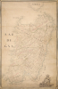
1720 Torri Mansucript Map of Sardinia (Sardenga) showing Tower System


[Sardegna.]
Sardinia becomes Italian.
$18,000.00
Choose a Collection:
- Digital Map Information
- Suitable for large format printing
- Full resolution TIFF file
- ICC color profile embedded
- Delivered instantly via download link
This Item
Enquire
Sardinia becomes Italian.
An exceptional and finely executed c. 1720 manuscript map of Sardinia (Sardegna), Italy. The map captures Sardinia as it transitioned from Spanish Habsburg to Savoyard rule following the War of the Quadruple Alliance (1718 - 1720). It was produced under the new Savoy rulers as an administrative and defensive tool to modernize the 16th-century Spanish tower system, cataloging existing towers and planning new ones. This transition marks the point when Sardinia became 'Italian'.A Closer Look
Coverage encompasses the island of Sardinia and the southernmost part of Corsica. Towns and villages throughout are labeled and illustrated with small vignettes - larger towns have more buildings. The meticulous detail is evidence of military training rather than private or commercial work.Along the coast, a network of towers is identified. Those in red are existing towers, while those in black labeled 'T' are planned new towers. The map also shows political and ecclesiastical divisions, some of which use older Spanish names. The language is a blend of Spanish and Italian, suggesting multiple sources. In general, the cartography of the interior is in Spanish, while the coastal detail is in Italian.
A striking and revealing heraldic crest decorates the lower right. The Quattro Mori shield is typical of Sardinia, having been introduced in the 13th century. The crown above the shield is distinctly of the House of Savoy, as is the lion in the lower left, thus placing this map in the context of the 1720 Savoyard assumption of sovereignty.
Reale Amministrazione delle Torri
In 1587, following repeated Ottoman and Barbary corsair raids on Sardinia, Philip II of Spain established the Reale Amministrazione delle Torri (Royal Administration of the Towers). The overall concept was to implement an encircling chain of coastal watchtowers connected by line of sight. By 1720, hundreds of towers had been built, but many were abandoned or in ruins, leaving massive gaps in the defensive network. Once Savoy assumed control of the island in 1720, they initiated a comprehensive survey of the island's defenses, including a plan to modernize the tower system by repairing existing towers and constructing dozens of new ones.There are at least two maps documenting this effort; likely, both are by the same hand. The present map is the more comprehensive, including extensive inland detail, topography, and political and ecclesiastical divisions. The other 'tower map', bearing the title, Carta del litorale del Regno di Sardegna in cui si vedono le torri esistenti e quelle in progetto, is held at the University of Cagliari Library, but, though also indicating proposed new towers using the same key system, it is more of a coastal outline, with no inland detail.
Publication History and Census
As a manuscript, this map is unique, despite the related map, as above. The work is otherwise unattributed, though it is likely the work of a Sardinian cartographer employed by the Reale Amministrazione delle Torri, based in Cagliari. Savoy inherited the administration from the Spanish and, despite changes in power, remained active until 1842.Condition
Good. Light soiling and even overall toning. Mansucript.