1862 U.S. Coast Survey Map of the Savannah River and Wassaw Sound
SavannahRiver-uscs-1862$1,200.00

Title
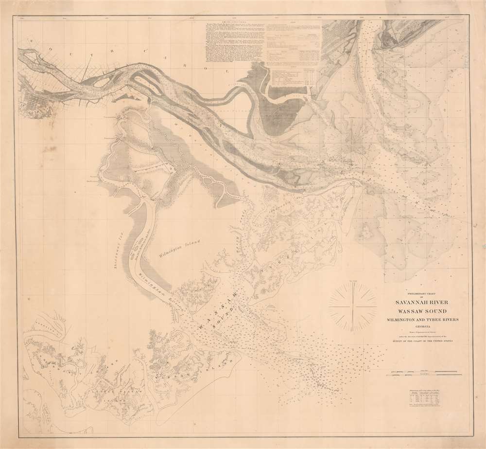
Preliminary Chart of Savannah River Wassaw Sound Wilmington and Tybee Rivers Georgia.
1862 (undated) 32 x 35 in (81.28 x 88.9 cm) 1 : 40000
1862 (undated) 32 x 35 in (81.28 x 88.9 cm) 1 : 40000
Description
An exceptionally rare separate issue c. 1862 Civil War Era U.S. Coast Survey nautical chart or map of the Savannah River and surrounding waters. This chart combines existing surveys of the Savannah River with separate charts prepared of the Wassaw Sound and the Wilmington and Tybee Rivers. Given the presentation on heavier stock and the maps relative rarity, it is likely this was a separate issue prepared for naval action early in the American Civil War (1861 - 1865).
A Closer Look
Coverage follows the course of the Savannah River from Savannah itself and Hutchinson's Island to the Atlantic, and from Hilton Head to Skiddaway Island. It includes much of interest to the Union naval officer, including sailing directions and illustrations of the Confederate fortifications at Causten's Bluff and Whitemarsh Island. Period manuscript annotations highlight deep-water routes to Savannah as well as the locations of buoys land lightships.Publication History and Census
The chart is itself undated - unusual for the U.S.C.S. It is moreover on heavy stock. The 'Sailing Directions' references Boutelle's survey of 1862, making that the earliest possible date. This map was not printed in any of the annual Superintendent's Reports. The British Library lists maps of 1855 and 1867 with the same title, but we cannot find any evidence that the maps are identical. No further institutional copies could be located.CartographerS
The Office of the Coast Survey (1807 - present) founded in 1807 by President Thomas Jefferson and Secretary of Commerce Albert Gallatin, is the oldest scientific organization in the U.S. Federal Government. Jefferson created the "Survey of the Coast," as it was then called, in response to a need for accurate navigational charts of the new nation's coasts and harbors. The spirit of the Coast Survey was defined by its first two superintendents. The first superintendent of the Coast Survey was Swiss immigrant and West Point mathematics professor Ferdinand Hassler. Under the direction of Hassler, from 1816 to 1843, the ideological and scientific foundations for the Coast Survey were established. These included using the most advanced techniques and most sophisticated equipment as well as an unstinting attention to detail. Hassler devised a labor intensive triangulation system whereby the entire coast was divided into a series of enormous triangles. These were in turn subdivided into smaller triangulation units that were then individually surveyed. Employing this exacting technique on such a massive scale had never before been attempted. Consequently, Hassler and the Coast Survey under him developed a reputation for uncompromising dedication to the principles of accuracy and excellence. Unfortunately, despite being a masterful surveyor, Hassler was abrasive and politically unpopular, twice losing congressional funding for the Coast Survey. Nonetheless, Hassler led the Coast Survey until his death in 1843, at which time Alexander Dallas Bache, a great-grandson of Benjamin Franklin, took the helm. Bache was fully dedicated to the principles established by Hassler, but proved more politically astute and successfully lobbied Congress to liberally fund the endeavor. Under the leadership of A. D. Bache, the Coast Survey completed its most important work. Moreover, during his long tenure with the Coast Survey, from 1843 to 1865, Bache was a steadfast advocate of American science and navigation and in fact founded the American Academy of Sciences. Bache was succeeded by Benjamin Pierce who ran the Survey from 1867 to 1874. Pierce was in turn succeeded by Carlile Pollock Patterson who was Superintendent from 1874 to 1881. In 1878, under Patterson's superintendence, the U.S. Coast Survey was reorganized as the U.S. Coast and Geodetic Survey (C & GS) to accommodate topographic as well as nautical surveys. Today the Coast Survey is part of the National Oceanic and Atmospheric Administration or NOAA as the National Geodetic Survey. More by this mapmaker...
Alexander Dallas Bache (July 19, 1806 - February 17, 1867) was an American physicist, scientist and surveyor. Bache is best known in cartographic circles as the Superintendent of the U.S. Coast Survey from 1843 to 1865. Born in Philadelphia, Bache, a great grandson of the statesman and inventor Benjamin Franklin, had a varied career primarily focused on education. He toured Europe on behalf of Girard College and composed an important treatise on European Education. Later he served as president of Philadelphia's Central High School and was a professor of natural history and chemistry at the University of Pennsylvania. On the death of Ferdinand Rudolph Hassler, Bache was appointed Superintendent of the United States Coast Survey. Picking up where Hassler left off Bache presided over the Survey during its most prolific period and oversaw the mapping of most of the United States coastline. To this day his name appears on countless marine pilot books and U.S. Coast Survey nautical charts. For his work he was elected Associate Fellow of the American Academy of Arts and Sciences, a Fellow of the Royal Society of Edinburgh, and a Foreign Member of the Royal Society. Following the Civil War, Bache was elected a 3rd Class Companion of the Military Order of the Loyal Legion of the United States. He died at Newport, Rhode Island and was buried in the Congressional Cemetery in Washington, DC, where he is commemorated with a monument built by American architect Henry Hobson Richardson. Learn More...
Condition
Good. Even overall toning. Some soiling.
References
OCLC 557890825.