This item has been sold, but you can get on the Waitlist to be notified if another example becomes available, or purchase a digital scan.
1794 Stedman Map of Savanna, Georgia siege during Revolutionary War
SavannahSiege-stedman-1794$1,000.00

Title
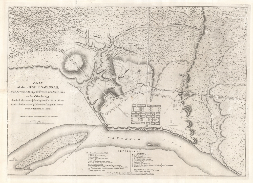
Plan of the Siege of Savannah, with the joint Attack of the French and Americans on the 9th October 1779 in which they were defeated by his Majesty's Forces under the Command of Major Genl. Augustin Prevost from a Survey by an Officer.
1794 (dated) 17 x 23.25 in (43.18 x 59.055 cm) 1 : 4500
1794 (dated) 17 x 23.25 in (43.18 x 59.055 cm) 1 : 4500
Description
A rare example of the sole contemporaneous map of the Siege of Savannah, published here in 1794 (second edition) for Charles Stedman. The map illustrates one of the bloodiest battles of the American Revolutionary War (1775 - 1783), in which a joint force of French and American soldiers attempted (and failed) to reclaim British-occupied Savannah.
A joint French-Continental effort to retake Savannah began in 1779, lasting from September 16th to October 18, 1779. The siege proper began on October 9th, as dated here, with French and American forces launching a concerted assault on the fortified British positions. The occupying British, under Major Augustin Prevost, successfully repulsed repeated major attacks, leading to some of the heaviest casualties of the war. Ultimately, with untenable losses, the Continental Army withdrew. The British remained in control of Savannah until July 1782, a year before the war ended.
The defeat was a heavy blow to both the Continental Army and their French allies. Neither subsequently published a plan of the event, likely to hide their humiliation. The British, however, were eager to celebrate the defense and a meticulously detailed plan was engraved and published in London by William Faden based upon accounts from Provost's engineers. That plan was modified to this plate in 1794.
A Closer Look
The map is oriented roughly to the south, with the city in a rough approximation of Oglethorpe's plan at center. British defensive positions are illustrated around the city, while Continental and French batteries and positions occupy the surrounding highlands. Trees, roads, and surrounding topography is also illustrated. Even the trajectory of cannon fire is noted. On the Savannah River, the positions of blockading American galleys are illustrated. The reference key at bottom center includes 14 notes and identifies 9 epaulments.Siege of Savannah
Following the 1777 Continental victory at Saratoga and the 1778 Treaty of Alliance with France, the British began to consider that they might potentially lose the war. Rather than face the Continental Army directly, they instead focused on supporting Loyalists, who they believed were predominant among the southern plantation colonies. They began a campaign to seize major southern ports, taking Savannah in 1778 and Charleston in 1780.A joint French-Continental effort to retake Savannah began in 1779, lasting from September 16th to October 18, 1779. The siege proper began on October 9th, as dated here, with French and American forces launching a concerted assault on the fortified British positions. The occupying British, under Major Augustin Prevost, successfully repulsed repeated major attacks, leading to some of the heaviest casualties of the war. Ultimately, with untenable losses, the Continental Army withdrew. The British remained in control of Savannah until July 1782, a year before the war ended.
The defeat was a heavy blow to both the Continental Army and their French allies. Neither subsequently published a plan of the event, likely to hide their humiliation. The British, however, were eager to celebrate the defense and a meticulously detailed plan was engraved and published in London by William Faden based upon accounts from Provost's engineers. That plan was modified to this plate in 1794.
Publication History and Census
This map was first engraved and published by William Faden in 1784, shortly after the American Revolutionary War ended. The plates were sold to Charles Stedman in the subsequent decade, who reissued the map for his 1794 History of the Origin, Progress, and Termination of the American War. The map and book are well represented institutionally, but scarce to the market, with only 4 known dealer listings in the past 10 years.CartographerS
William Faden (July 11, 1749 - March 21, 1836) was a Scottish cartographer and map publisher of the late 18th century. Faden was born in London. His father, William MacFaden, was a well-known London printer and publisher of The Literary Magazine. During the Jacobite Rebellion (1745 - 1746), MacFaden changed his family name to Faden, to avoid anti-Scottish sentiment. Faden apprenticed under the engraver James Wigley (1700 - 1782), attaining his freedom in 1771 - in the same year that Thomas Jefferys Sr. died. While Thomas Jefferys Sr. was an important and masterful mapmaker, he was a terrible businessman, and his son, Jefferys Jr., had little interest in building on his father's legacy. MacFaden, perhaps recognizing an opportunity, purchased his son a partnership in the Jefferys firm, which subsequently traded as 'Faden and Jefferys'. Jefferys Jr. also inherited Jefferys Sr.'s title, 'Geographer to the King and to the Prince of Wales'. With little interest in cartography or map publishing, Jefferys Jr. increasingly took a back seat to Faden, and by 1776, he had withdrawn from day-to-day management, although he retained his financial stake. The American Revolutionary War (1775 - 1783) proved to be a boom for the young 'Geographer to the King', who leveraged existing materials and unpublished manuscript maps to which he had access via his official appointment to publish a wealth of important maps, both for official use and the curious public - this period of prosperity laid the financial underpinning for Faden, who by 1783, at the end of the war, acquired full ownership of the firm and removed the Jefferys imprint. In 1801, he engraved and published the first maps for the British Ordnance Survey. By 1822, Faden published over 350 maps, atlases, and military plans. He retired in 1823, selling his plates to James Wyld Sr. Faden died in 1836. More by this mapmaker...
Charles Stedman (December 22, 1753 - June 26, 1812) was a British-American military officer who served during the American Revolutionary War (1775 - 1783). He was born in Philadelphia, Pennsylvania and took a law degree and William and Mary College, Virginia. Despite being American born, Stedman was a staunch Loyalist. When the Revolution broke out, he supported the crown and was awarded with a commissary post under British commander Sir William Howe. Stedman was fluent in German, perhaps learnt through connections with Pennsylvania German settlers, and became invaluable as an intermediary between Howe and Hessian auxiliaries. Twice he was captured and sentenced to death, and twice he escaped before the execution could be carried out. After the peace of 1783, he retired to England with the half-pay of a Colonel. He dedicated himself subsequently to compiling a history of the Revolutionary War, which was published in 1794. Later, from 1797, he worked at the office of deputy controller and accountant-general of the revenue of stamps. After his death in 1812, he was buried at Paddington. Learn More...
Source
Stedman, C., History of the Origin, Progress, and Termination of the American War, (London) 1794.
Condition
Average. Lower left margin reinstated to neatline. Several closed tears repaired and reinforced on verso. Minor surface abrasion along original fold lines.
References
OCLC 10314712. Boston Public Library, Leventhal Center, 06_01_008144. Nebenzahl, K., A Bibliography of Printed Plans of the American Revolution, 1775-1795, #76. Nebenzahl, K., and Higginbotham, D., Atlas of the American Revolution, pp. 166-7 (first state).