Digital Image: 1794 Stedman Map of Savanna, Georgia siege during Revolutionary War
SavannahSiege-stedman-1794_d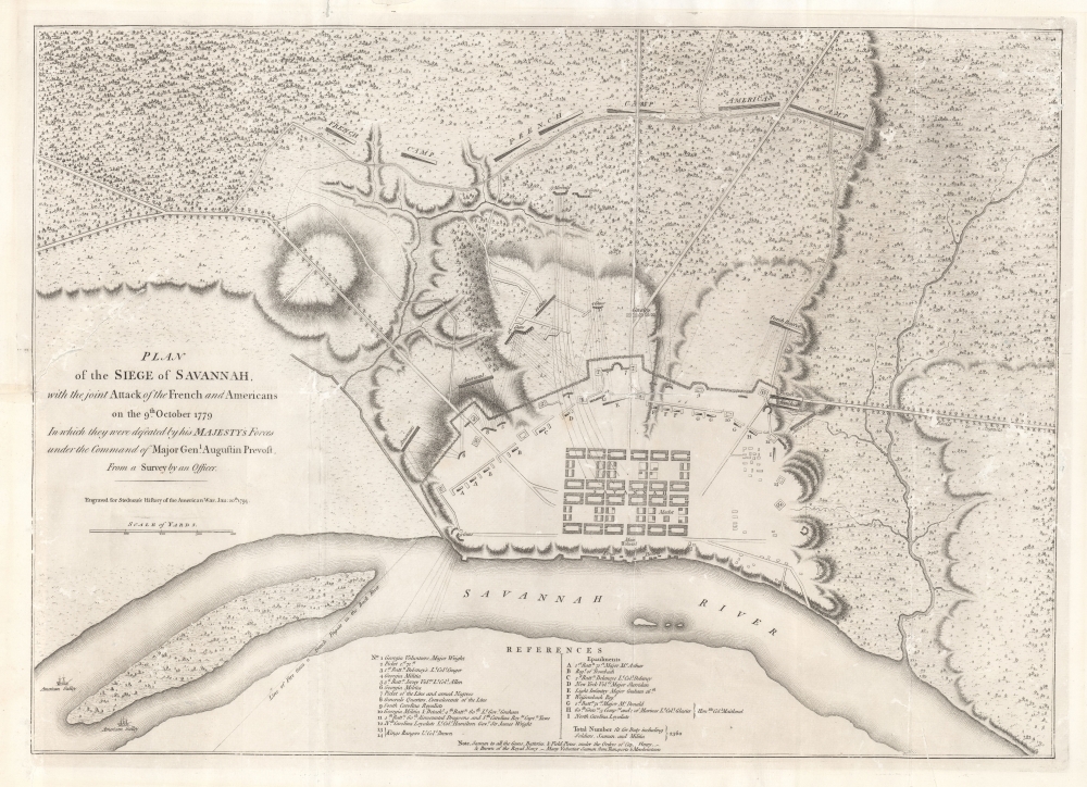

Title
Plan of the Siege of Savannah, with the joint Attack of the French and Americans on the 9th October 1779 in which they were defeated by his Majesty's Forces under the Command of Major Genl. Augustin Prevost from a Survey by an Officer.
1794 (dated) 17 x 23.25 in (43.18 x 59.055 cm) 1 : 4500
1794 (dated) 17 x 23.25 in (43.18 x 59.055 cm) 1 : 4500
Description
FOR THE ORIGINAL ANTIQUE MAP, WITH HISTORICAL ANALYSIS, CLICK HERE.
Digital Map Information
Geographicus maintains an archive of high-resolution rare map scans. We scan our maps at 300 DPI or higher, with newer images being 600 DPI, (either TIFF or JPEG, depending on when the scan was done) which is most cases in suitable for enlargement and printing.
Delivery
Once you purchase our digital scan service, you will receive a download link via email - usually within seconds. Digital orders are delivered as ZIP files, an industry standard file compression protocol that any computer should be able to unpack. Some of our files are very large, and can take some time to download. Most files are saved into your computer's 'Downloads' folder. All delivery is electronic. No physical product is shipped.
Credit and Scope of Use
You can use your digial image any way you want! Our digital images are unrestricted by copyright and can be used, modified, and published freely. The textual description that accompanies the original antique map is not included in the sale of digital images and remains protected by copyright. That said, we put significant care and effort into scanning and editing these maps, and we’d appreciate a credit when possible. Should you wish to credit us, please use the following credit line:
Courtesy of Geographicus Rare Antique Maps (https://www.geographicus.com).
How Large Can I Print?
In general, at 300 DPI, you should at least be able to double the size of the actual image, more so with our 600 DPI images. So, if the original was 10 x 12 inches, you can print at 20 x 24 inches, without quality loss. If your display requirements can accommodate some loss in image quality, you can make it even larger. That being said, no quality of scan will allow you to blow up at 10 x 12 inch map to wall size without significant quality loss. For more information, it is best consult a printer or reprographics specialist.
Refunds
If the high resolution image you ordered is unavailable, we will fully refund your purchase. Otherwise, digital images scans are a service, not a tangible product, and cannot be returned or refunded once the download link is used.
Cartographer S
William Faden (July 11, 1749 - March 21, 1836) was a Scottish cartographer and map publisher of the late 18th century. Faden was born in London. His father, William MacFaden, was a well-known London printer and publisher of The Literary Magazine. During the Jacobite Rebellion (1745 - 1746), MacFaden changed his family name to Faden, to avoid anti-Scottish sentiment. Faden apprenticed under the engraver James Wigley (1700 - 1782), attaining his freedom in 1771 - in the same year that Thomas Jefferys Sr. died. While Thomas Jefferys Sr. was an important and masterful mapmaker, he was a terrible businessman, and his son, Jefferys Jr., had little interest in building on his father's legacy. MacFaden, perhaps recognizing an opportunity, purchased his son a partnership in the Jefferys firm, which subsequently traded as 'Faden and Jefferys'. Jefferys Jr. also inherited Jefferys Sr.'s title, 'Geographer to the King and to the Prince of Wales'. With little interest in cartography or map publishing, Jefferys Jr. increasingly took a back seat to Faden, and by 1776, he had withdrawn from day-to-day management, although he retained his financial stake. The American Revolutionary War (1775 - 1783) proved to be a boom for the young 'Geographer to the King', who leveraged existing materials and unpublished manuscript maps to which he had access via his official appointment to publish a wealth of important maps, both for official use and the curious public - this period of prosperity laid the financial underpinning for Faden, who by 1783, at the end of the war, acquired full ownership of the firm and removed the Jefferys imprint. In 1801, he engraved and published the first maps for the British Ordnance Survey. By 1822, Faden published over 350 maps, atlases, and military plans. He retired in 1823, selling his plates to James Wyld Sr. Faden died in 1836. More by this mapmaker...
Charles Stedman (December 22, 1753 - June 26, 1812) was a British-American military officer who served during the American Revolutionary War (1775 - 1783). He was born in Philadelphia, Pennsylvania and took a law degree and William and Mary College, Virginia. Despite being American born, Stedman was a staunch Loyalist. When the Revolution broke out, he supported the crown and was awarded with a commissary post under British commander Sir William Howe. Stedman was fluent in German, perhaps learnt through connections with Pennsylvania German settlers, and became invaluable as an intermediary between Howe and Hessian auxiliaries. Twice he was captured and sentenced to death, and twice he escaped before the execution could be carried out. After the peace of 1783, he retired to England with the half-pay of a Colonel. He dedicated himself subsequently to compiling a history of the Revolutionary War, which was published in 1794. Later, from 1797, he worked at the office of deputy controller and accountant-general of the revenue of stamps. After his death in 1812, he was buried at Paddington. Learn More...
Source
Stedman, C., History of the Origin, Progress, and Termination of the American War, (London) 1794.