This item has been sold, but you can get on the Waitlist to be notified if another example becomes available, or purchase a digital scan.
1757 Homann Heirs Map of Saxony, Germany, and the Czech Republic
Saxoniae-hmhr-1757$150.00

Title
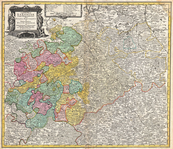
Circuli Supe. Saxoniae Pars Meridionalis sive Ducatus Electoratus et Principatus Ducum Saxoniae…
1757 (undated) 19 x 22 in (48.26 x 55.88 cm)
1757 (undated) 19 x 22 in (48.26 x 55.88 cm)
Description
A fine example of the Homann Heirs map of Saxony, Germany. Covers from Berlin in the north, to Prague in the southeast and Efurt in the west. The map is filled with information including fortified cities, villages, roads, bridges, forests, battlefields, castles and topography. Title cartouche in the upper left quadrant features a wonderful mining vignette, the Greek god Hermes, and a warrior figure with a shield featuring the head of Medusa. Prepared in Nuremberg by the engravers Adam Friedrich Zürner and Zolman for issue in Homann Heirs' Maior Atlas Scholasticus.
CartographerS
Homann Heirs (1730 - 1848) were a map publishing house based in Nuremberg, Germany, in the middle to late 18th century. After the great mapmaker Johann Baptist Homann's (1664 - 1724) death, management of the firm passed to his son Johann Christoph Homann (1703 - 1730). J. C. Homann, perhaps realizing that he would not long survive his father, stipulated in his will that the company would be inherited by his two head managers, Johann Georg Ebersberger (1695 - 1760) and Johann Michael Franz (1700 - 1761), and that it would publish only under the name 'Homann Heirs'. This designation, in various forms (Homannsche Heirs, Heritiers de Homann, Lat Homannianos Herod, Homannschen Erben, etc..) appears on maps from about 1731 onwards. The firm continued to publish maps in ever diminishing quantities until the death of its last owner, Christoph Franz Fembo (1781 - 1848). More by this mapmaker...
Adam Friedrich Zürner (1679 - 1742) was a German engraver, pastor and scientist based in Dresden Germany. His is known to have worked with the Homann Heirs firm as well as several other cartographic firms of the era. His cartographic work primarily focuses on Saxony and parts of Germany. Learn More...
Source
Major Atlas Scholasticus Ex Triginta sex Generalibus et Specialibus Mappis Homannianis..., c. 1760.
Condition
Very good condition. Blank on verso. A fine dark impression. Rich original color.
References
Stanford University, Map Collection, Germany 0307.