
1595 Ortelius Map of Central-Eastern Germany (Saxony, Thuringia, Brandenburg)

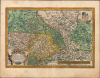
Saxoniae, Misniae, Thuringiae, Nova Exactissimaque Descriptio.
Birthplace of the the Reformation.
- Digital Map Information
- Suitable for large format printing
- Full resolution TIFF file
- ICC color profile embedded
- Delivered instantly via download link
Birthplace of the the Reformation.
This is an old-color 1595 map of large portions of what is now central Germany and Czechia, including Saxony, Thuringia, and Brandenburg, that appeared in Abraham Ortelius' Theatrum Orbis Terrarum. This region was the birthplace of Lutheranism and, by extension, the Protestant Reformation, being the stage upon which many of the key early events of the Reformation took place.A Closer Look
This map covers a large portion of central and eastern Germany and northern Czechia/Bohemia (then the Holy Roman Empire), from Hildesheim in the northwest to Frankfurt (an der Oder) in the northeast, and from the area around Erfurt and Gera (Egra here, in the bottom border) in the southwest to Prague (below the scale) in the southeast. The cities of Berlin (the 'twin cities' of Berlin-Cölln on either side of the Spree), Brandenburg, Magdeburg, Leipzig (Leypzig), Erfurt (Erphurdt), and Dresden (Dresdan) appear, among other cities, towns, and villages. Rivers, including especially the Elbe and its tributaries, forests, mountains, and mines (metalli fodinas) are also illustrated and labelled throughout. Regions, such as Saxony, Thuringia, Silesia, and 'Marchia' (the March or Margraviate of Brandenburg) are color-shaded. The verso contains a brief historical and geographic overview of the regions presented on the map, collected loosely under the title 'Saxony.'Historical Context
This region was the heart of the Lutheran Protestant Reformation and home to Martin Luther (1483 - 1546) himself, who was born in Eisleben (Eiisleben here), was educated in Mansfeld, Magdeburg, and Erfurt, and taught at the University of Wittenberg (here as Witteberg, at center towards top). Luther served as a vicar for Saxony and Thuringia and traveled throughout the region before he became the leader of the Protestant Reformation, though the story about him nailing the Ninety-Five Theses to the door of the cathedral in Wittenberg is probably apocryphal. Many of the key early events of the Reformation also took place in this region, with Frederick III (1463 - 1525) 'the Wise,' the Elector of Saxony, offering critical protection to Luther in times of peril, even staging a fake highway robbery when Luther was returning to Wittenberg from the dramatic showdown at the Diet of Worms in order to safely transport him to the imposing Wartburg Castle at Eisenach (Isenach here).As would soon happen throughout Europe, the Reformation divided local powers in Saxony and surrounding regions, and religious divisions soon became entangled with power struggles within the Holy Roman Empire (with Lutheranism generally seen as a ruse for seeking greater autonomy from the House of Habsburg, though opportunistic alliances could form across the confessional divide). Following the Schmalkaldic War (1546 - 47) and the 1555 Peace of Augsburg, religious conflict subsided somewhat, with the guiding principle of Cuius regio, eius religio, which effectively granted princes of the Holy Roman Empire autonomy in determining confessional allegiance, with the expectation that their subjects would follow suit (ius reformandi) or emigrate to a territory conforming to their religious affiliation. In reality, most of the population of central Germany had become firmly Lutheran by this point, and any Catholic princes were clever enough not to press the religious issue too much as long as their subjects were loyal in political matters.
Unfortunately, the Peace of Augsburg did not address the issue of Church property within the framework of Cuius regio, eius religio, nor discuss how to react to the emergence of new confessions (i.e. Calvinism), leading ultimately to the Thirty Years' War, which devastated parts of Saxony and nearby regions.
Publication History and Census
This map was published by Abraham Ortelius in the 1595 Latin edition of the Theatrum Orbis Terrarum, of which 500 Copies were printed. It appeared in the Theatrum between 1570 and 1609, and in its various printings is well-represented in institutional collections and occasionally appears on the market. That being said, the present edition is only independently cataloged in OCLC among the holdings of the Duchess Anna Amalia Library in Weimar, the Sächsische Landesbibliothek - Staats- und Universitätsbibliothek Dresden, and the Biblioteca Nacional de España.Cartographer
Abraham Ortelius (April 14, 1527 - June 28, 1598) also known as Ortels, was a cartographer, geographer, and cosmographer of Brabant, active in Antwerp. He was the creator of the first modern atlas, Theatrum Orbis Terrarum and is a seminal figure in the history of cartography. Along with Gerard Mercator and Gemma Frisius, he was a founder of the Netherlandish school of cartography. His connections with Spain - culminating in his 1575 appointment as Royal Cartographer to King Phillip II of Spain - gave him unmatched access to Spanish geographical knowledge during a crucial period of the Age of Discovery. Ortelius was born in 1527 in Antwerp. In 1547 he entered the Antwerp Guild of Saint Luke as an illuminator of maps. He began trading in books, prints, and maps, traveling regularly to the Frankfurt book and print fair, where in 1554 he met Mercator. He accompanied Mercator on journeys throughout France in 1560 and it was at this time, under Mercator's influence, that he appears to have chosen his career as a scientific geographer. His first published geographic work appeared in 1564, an eight-sheet cordiform world map. A handful of other maps preceded the 1570 publication of the first edition of the Theatrum Orbis Terrarum, which would prove to be his life work. Appearing with but 53 maps in its first edition, Ortelius' work expanded with new maps added regularly. By 1592, it had 134 maps. Many of Ortelius' maps remained the standard for nearly a century. He traveled extensively, but his genius was as a compiler, locating the best informed maps on which to base his own. His contacts throughout Europe and extending even (via the Portuguese) to the Far East were formidable. Moreover, many of his maps were based on his own scholarship, particularly his historical works. His theories of geography were particularly ahead of his time with respect to the notion of continental drift, the possibility of which he mused on as early as 1596, and which would be proven correct centuries later. In a sense his greatest achievement was his successful navigation of the religious and political violence endemic to his city throughout his adult life: The Dutch Revolt, or Eighty Years' War (1568 - 1648), fully embroiled Antwerp. Although outwardly and officially recognized as Catholic (Arias Montanus vouched for Ortelius' Catholic orthodoxy prior to his appointment as Royal Geographer), Ortelius was able to separate himself from the religious furor which characterized the war in the low countries. Ortelius showed a glimpse of himself in a letter to a friend, regarding humanist Justus Lipsius: 'I do not know whether he is an adherent of the Pope or a Calvinist, but if he has ears to hear, he will neither be one nor the other, for sins are committed on both sides'. Ortelius' own explorations of Biblical history in his maps, and the Christogram contained in his own motto, suggest him to be a religious man, but his abjuration of political religious authorities mark him as an individualist. His tombstone at St Michael's Præmonstratensian Abbey in Antwerp bears the inscription, Quietis cultor sine lite, uxore, prole. ('served quietly, without accusation, wife, and offspring.') Further Details...
Condition
Very good. Some spotting and uneven toning in margin, slight wear along centerfold in bottom margin.
References
OCLC 837037981, 698867402, 864324688.