This item has been sold, but you can get on the Waitlist to be notified if another example becomes available, or purchase a digital scan.
1535 Fries / Clavus Map of Scandinavia - Medieval Mapping of the North
Scandinavia-fries-1522$1,125.00

Title
Norbegia et Gottia.
1522 (undated) 13.25 x 17.75 in (33.655 x 45.085 cm) 1 : 6200000
1522 (undated) 13.25 x 17.75 in (33.655 x 45.085 cm) 1 : 6200000
Description
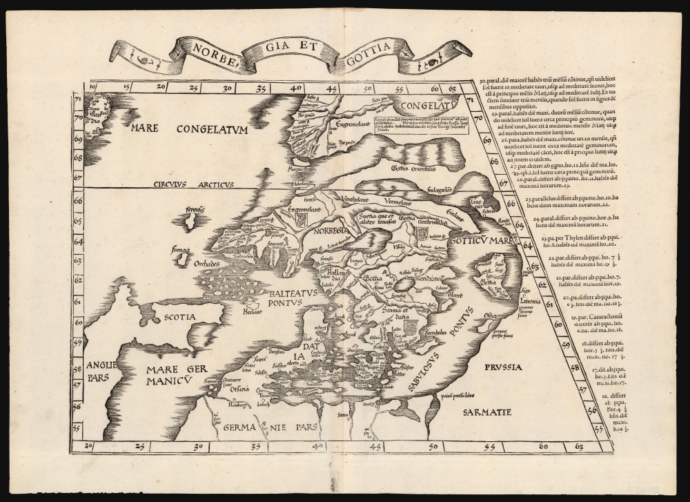
This is Lorenz Fries' 1522 map, in a 1535 edition, of one of the earliest maps to focus on the northern parts of Europe, including Iceland and Greenland. It is one of the earliest acquirable maps to include the geography of Claudius Clavus (1388 - 14??).
Fries includes a text block - an addition not present on the precursor Waldseemüller map or the earlier printed versions of the Clavus map - describing Greenland as
Scope of the Map
The map is drawn on a Ptolemaic trapezoidal projection. Coverage reaches south to include England, Scotland, Denmark, and Prussia (all follow Ptolemaic topography, but Denmark uses contemporary place names), and northwards to embrace the Baltic Sea, Sweden, Norway, and Finland. Iceland appears at the extreme upper left, though erroneously situated north of the Arctic Circle, whose waters are noted to be frozen. Beyond this frozen sea, the 'Mare Congealtum' - yet connected to the European landmass - is Greenland.Greenland
It may be that Clavus is not to blame for this map's astonishing placement of Greenland here. Records suggest he produced two manuscript maps of this region, but only the first survives. On that map, Greenland is more accurately placed to the west of Scandinavia. The manuscript of the second Clavus map has not survived. However, it is understood to have been the basis for the maps of Nicolaus Donnus Germanus (c. 1420 - 1490), whose delineations were used by all but one of the early printed Ptolemies and thus provided the basis for the present work. So, while it is possible that Clavus had two different delineations Greenland, it is just as likely that the placement of Greenland as a northern Peninsula is an arbitrary change instituted by Germanus. Regardless of the source of the distortion, the placement of Greenland due north of Scandinavia may be a consequence of Ptolemy's cruder, first, projection, whose trapezoids were simple to use but imperfectly reflected the curvature of the Earth. Clavus' placenames applied to Greenland were invented - or rather, repurposed from the lyrics of a Swedish folk song. His sources are unknown but likely derive from oral reports by mariners who had sailed from Norway to Iceland and possibly Greenland. He may also have benefited from reports of the far-reaching Hanseatic traders.Fries includes a text block - an addition not present on the precursor Waldseemüller map or the earlier printed versions of the Clavus map - describing Greenland as
Very abundant in precious furs, which are brought to Western ports. This region, having overthrown its own leader, is subject to the Russian ruler. The savage inhabitants are similar in countenance to the Samoyeds. (from Latin)If we assume, as the map does, a land connection between northern Europe and Greenland, a Russian connection is feasible. The Sami, Inuit, and other peoples of the far north had much more in common with each other than with people to the south, and an observed similarity there is entirely reasonable.
Publication History and Census
This map was first issued in the 1522 Lorenz Fries Strasbourg edition of Ptolemy's Geographia. A further edition was produced in that same city in 1525. Afterward, two further editions of 1535 and 1541 were published in Lyons and Vienne-in-the-Dauphane, respectively. The editor of the 1535 edition, Michael Villanovus (Servetus), was tried for heresy in 1553 and burned at the stake. Reportedly, Calvin ordered copies of the Servetus edition burned. Consequently, maps from the 1535 edition (of which this is a representative) are scarce. Overall, the four editions of Fries' Ptolemy are well represented in institutional collections, although we do not see a separate example of this map listed in OCLC.CartographerS
Lorenz Fries (c. 1490 – 1531) was a German cartographer, cosmographer, astrologer, and physician based in Strasbourg. Little is known of Fries' early life. He may have studied in Padua, Piacenza, Montpellier, and Vienna, but strong evidence of this is unfortunately lacking. The first recorded mention of Fries on a 1513 Nuremberg broadside. Fries settled in Strasbourg in March of 1519, where he developed a relationship with the St. Die scholars, including, among others, Walter Lud, Martin Ringmann, and Martin Waldseemüller. There, he also befriended the printer and publisher Johann Grüninger. Although his primary profession was as a doctor, from roughly 1520 to 1525, he worked closely with Grüninger as the geographic editor of various maps and atlases based upon the work of Martin Waldseemüller. Although his role is unclear, his first map seems to have been a 1520 reissue of Waldseemüller's world map of 1507. Around this time, Fries also began working on Grüninger's reissue of Waldseemüller's 1513 edition of Ptolemy's Geographie Opus Novissima. That edition included three new maps by Fries based upon the Waldseemüller world map of 1507 – two of these, his maps of East Asia and Southeast Asia, are quite significant as the first specific maps of these regions issued by a European publisher. In 1525, Fries decided to leave Strasbourg and surrendered his citizenship, relocating to Trier. In 1528, he moved to Basel. Afterward, he relocated to Metz where he most likely died. In addition to his cartographic work, Fries published tracts on medicine, religion, and astrology. More by this mapmaker...
Claudius Clavus (Danish: Claudius Claussøn), (September 14, 1388 - ?) was a Danish geographer, remembered for having produced the first mapping of Scandinavia, Iceland and Greenland: his medieval mapping of the north remained the standard for the mapping of Iceland until well into the 16th century. He is thought to have been born on the island of Funen, in the village of Salling. At the age of 25 he began to travel in Europe - he is thought to have traveled as to the northernmost parts of Norway - but he arrived in Rome in around 1423. There he befriended well placed papal scholars who were working to update Ptolemy's geographical ideas; he contributed the first realistic description of the north parts of Europe, particularly those beyond 63° North, which had been the northern limit of Ptolemy's Oikoumene. Clavus included the first accurate placement of Iceland, and what was probably the first instance of Greenland to appear on a map. (He included as well a number of placenames, which he invented - or rather, repurposed - from the lyrics of songs. Most of his own work has been lost. Copies of his map of the north were made by Donnus Nicolaus Germanus, and through him Clavus' map became part of canon. He also drew up a manuscript copy of the Ptolmaic maps, 27 maps of which survive. Learn More...
Source
Ptolemy, C., Geographicae Enarrationis..., (Lyons: Servetus) 1535.
Condition
Excellent. Few tiny wormholes, else fine.
References
Ginsberg, W., Scandia: Important Early Maps of the Northern Regions and Maps and Charts of Norway, #7 (1513 Waldseemuller). Rumsey 10891.101 (1525).