This item has been sold, but you can get on the Waitlist to be notified if another example becomes available, or purchase a digital scan.
1849 Greenleaf Map of Scandinavia
Scandinavia-greenleaf-1849$125.00

Title
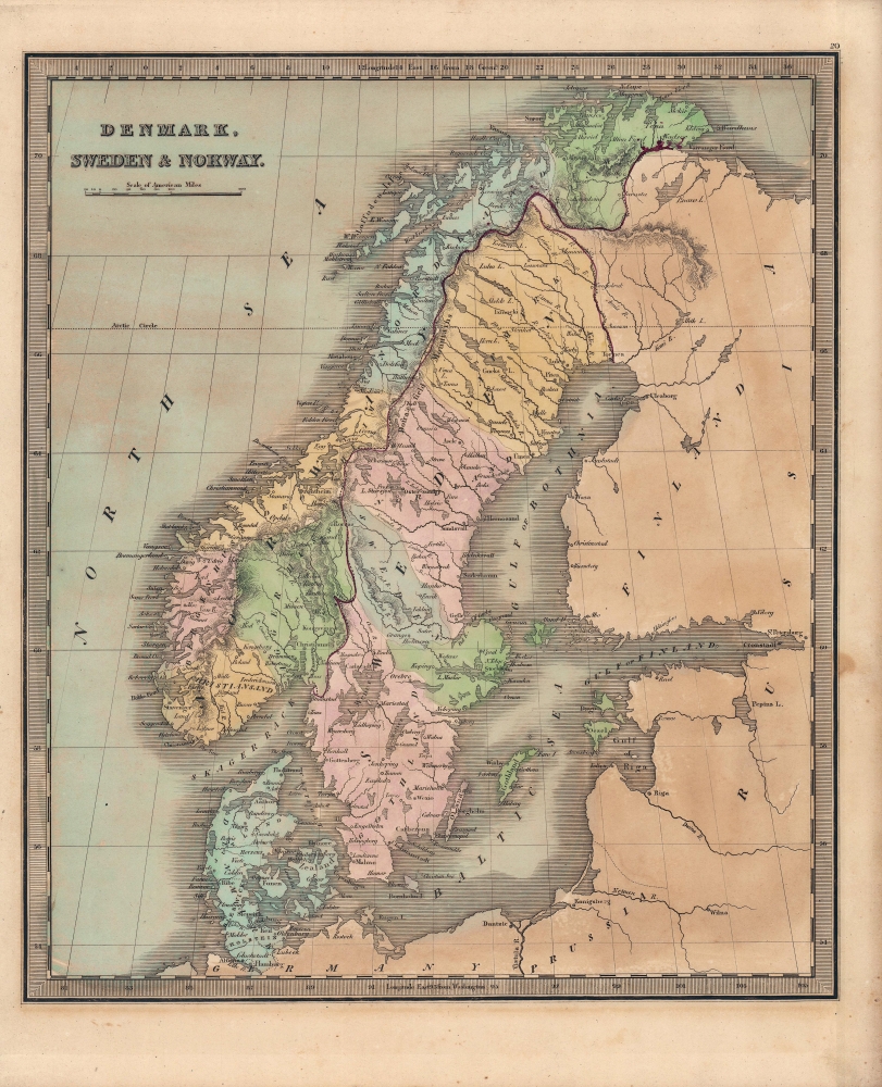
Denmark, Sweden and Norway.
1849 (undated) 12.5 x 10.75 in (31.75 x 27.305 cm) 1 : 6800000
1849 (undated) 12.5 x 10.75 in (31.75 x 27.305 cm) 1 : 6800000
Description
A lovely map of Scandinavia (Denmark, Sweden, and Norway) published in the 1849 edition of Jeremiah Greenleaf's Universal Atlas.
The legendary and semi-mythical whirlpool known as the Maelstrom (Mahlstrom) in northwestern Norway is noted. This legendary whirlpool was the inspiration for Edgar Allen Poe's classic tale 'Descent into the Maelstrom.' In reality, it is a periodic and powerful current caused by tidal variations in the region.
A Closer Look
The map covers Denmark, Norway, and Sweden in detail and identifies various cities, towns, rivers, mountain passes, and an assortment of additional topographical details. Sweden and Norway are divided by a thick purple line. Though the two kingdoms remained functionally independent, they were unified for most of the 19th century through the Swedish royal family. Regions of both kingdoms, and of Denmark, are labeled and in most cases shaded to easily distinguish them.The legendary and semi-mythical whirlpool known as the Maelstrom (Mahlstrom) in northwestern Norway is noted. This legendary whirlpool was the inspiration for Edgar Allen Poe's classic tale 'Descent into the Maelstrom.' In reality, it is a periodic and powerful current caused by tidal variations in the region.
Historical Context
When this map was published, Scandinavia, like most of Europe, was undergoing radical changes as a result of long-building forces that were unleashed in the upheavals of 1848. However, the region was further convulsed by the First Schleswig War, which divided German speakers and non-German speakers in Schleswig (here as Sleswick), Holstein, and Lauenberg, with the former rebelling against the Danish king, a conflict in which the Prussian-led German Confederation and other surrounding powers quickly became embroiled. Ultimately, Denmark was able to suppress the rebellion with the assistance of foreign powers, especially Sweden-Norway. The conflict marked a highpoint of pan-Scandinavian identity, but remnant German dissatisfaction over the Schleswig-Holstein Question led to a second war in 1864, which the Prussians handily won, a prelude to their defeat of the Austrians two years later and a major steppingstone in the unification of Germany.Publication History and Census
This map is a much-revised Greenleaf issue of David Hugh Burr's 1833 map of the same. The Burr map plates fell into the hands of Jeremiah Greenleaf, who revised them for publication in his own Universal Atlas. The present example is from the 1849 edition of the atlas, the last and final, which was extensively revised over the 1848 edition. We note an example in the David Rumsey Map collection, which has been populated digitally throughout OCLC, making a comprehensive survey of existing physical examples nearly impossible. Nonetheless, the 1849 edition of the atlas is rare, which Rumsey correctly notes is not in Karpinski. We do note an example, however, in Phillips.CartographerS
Jeremiah Greenleaf (1791 - 1864) is a little known but highly admired American cartographer of the early 19th century. He published from roughly 1830 to 1850. His most important work is A New Universal Atlas; Comprising of all the Principal Empires, Kingdoms, and States Throughout the World and Forming a distinct Atlas of the United States, published in several editions in the 1840s. Many of his maps are reformatted versions of his contemporary David Burr's much admired cartographic works. Greenleaf's maps are extremely rare and admired for their stunningly vivid pastel color washes. More by this mapmaker...
David Hugh Burr (August 18, 1803 - December 25, 1875) of one of the first and most important truly American cartographers and map publishers. Burr was born in Bridgeport Connecticut in August of 1803. In 1822 Burr moved to Kingsboro, New York to study law. A year and a half later he was admitted to the New York Bar association. Burr must have questioned his choice of careers because shortly after being admitted to the Bar, he joined the New York State Militia. Though largely untrained in the art of surveying, Burr was assigned to work under Surveyor General of New York, Simeon De Witt, to survey several New York Roadways. Seeing a window of opportunity, Burr was able to negotiate with the governor of New York at the time, De Witt Clinton, to obtain copies of other New York survey work in order to compile a map and Atlas of the state of New York. Recognizing the need for quality survey work of its territory, the government of New York heartily endorsed and financed Burr's efforts. The resulting 1829 Atlas of the State of New York was the second atlas of an individual U.S. state and one of the most important state atlases ever produced. Burr went on to issue other maps both of New York and of the United States in general. In cooperation with publishing firm of Illman & Pillbrow, he produced an important New Universal Atlas and, with J.H. Colton, several very important maps of New York City. In recognition of this work, Burr was appointed both "Topographer to the Post office" and "Geographer to the House of Representatives of the United States". Later, in 1855, Burr was assigned to the newly created position of Surveyor General to the State of Utah. Burr retired from the position and from cartographic work in general in 1857 when light of some of his financial misdeeds and frauds came to light. He was accused of submitting false expense reports and underpaying employees, among other indiscretions. Learn More...
Source
Greenleaf, J., New Universal Atlas, (Brattleboro, Vermont: Greenleaf) 1849.
Condition
Very good. Even overall toning. Minor imperfections, mostly confined to margins.
References
Rumsey 15176.024.